Machine Learning and Data Analytics in Geosciences
The Stackable Certificate Program on Machine Learning and Data Analytics in Geosciences is designed to train students on the fundamentals of artificial intelligence while working at the forefront of Earth and data science.
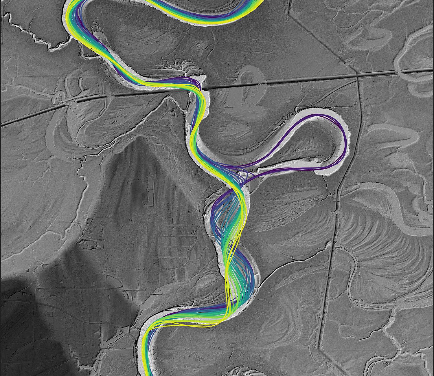
Students learn to use modern data analytics tools and machine learning to solve Earth science problems involving large volumes of data, such as climate modeling, seismic imaging, earthquake forecasting and satellite mapping. Students also learn to use the programming language Python.
Through this certificate program you will:
Boost Your Research
- Code AI models
- Create AI-driven visualizations
- Solve complex geoscience problems
Gain AI Expertise
- Build AI and machine learning skills
- Apply data analytics technology
- Learn to code in Python
- Complete an industry-ready research project
Eligibility
Available now to both UT Austin degree-seeking and UT Austin non-degree-seeking graduate students of any discipline.
The deadline for applications is July 1. Students currently enrolled at The University can submit application materials until August 1.
Requirements
- 12 credit hours from core courses
- Required course: Machine Learning Research, with capstone research project (GEO 396D.5)
- Most courses can or will be offered in a hybrid mode. Applicants are not required to be residents within the UT Austin area.
How to Apply
Non UT students |
|
Current UT students |
|
This is an online process. Do not mail your application materials. For an application to be complete, all materials must be submitted by the deadline. For more information and specific instructions about how to apply visit the Graduate School Admissions – How to Apply. Items for the application process:
|
|
Submit the below items via one email to both the graduate coordinators and the program director. Items for the application process:
College transcripts will be reviewed via secure UT Austin methods. NEVER email transcripts.
|
| Apply Now | Email Application |
Questions about the application process can be referred to the graduate coordinators.
Completed applications will be reviewed by the admissions committee.
Admissions Committee
- Mrinal Sen
- Sergey Fomel
- Richard Ketcham
- Dev Niyogi
Meet Your Faculty
Mrinal Sen
Program Director
Professor, Department of Earth and Planetary Sciences & University of Texas Institute for Geophysics, Jackson School of Geosciences
Sergey Fomel
Professor, Bureau of Economic Geology & Department of Earth and Planetary Sciences, Jackson School of Geosciences
Richard Ketcham
Professor, Department of Earth and Planetary Sciences, Jackson School of Geosciences

Dev Niyogi
Professor, Department of Earth and Planetary Sciences, Jackson School of Geosciences & Maseeh Department of Civil, Architectural, and Environmental Engineering

Jacob Covault
Research Professor, Bureau of Economic Geology, Jackson School of Geosciences
Zoltan Sylvester
Research Professor, Bureau of Economic Geology, Jackson School of Geosciences

Michael Pyrcz
Professor, Hildebrand Department of Petroleum and Geosystems Engineering, Cockrell School of Engineering
Research Group Highlights
Sen Research Group
Grad student Arnab Dhara’s research on deep-learning approach to full-waveform inversion was featured in SEG’s Seismic Soundoff podcast.
Marc Hesse Geological Fluid Mechanics Group
Grad student Afzal Shadab turned to deep learning neural networks to unravel the fluid mechanics of groundwater. His findings were published in the journal Advances in Water Resources.
Dev Niyogi TE(x)US L∆B
Preparing cities to be ‘climate ready’ is now a critical part of long term urban resilience. Postdoc Manmeet Singh developed a deep learning tool that models rain and flooding in cities down to the street level.
TEXNET
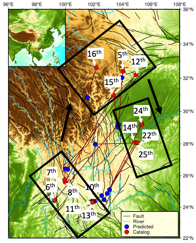
Former grad student Yangkang Chen developed an algorithm that predicted earthquakes with unprecedented accuracy, raising hopes of AI bringing future breakthroughs.
Automating Well Logs
Prof. Zoltán Sylvester developed software that automatically correlates vast volumes of well log data. The research was published in Basin Research and offers important applications for paleoclimate research.
Announcing a New Certificate Program!
A new certificate program at UT Jackson School of Geosciences will build critical skills for the geosciences workforce by training students and professionals to use modern data analytics tools and machine learning.
Join the AI Revolution
Enhance your impact with AI and get ready for the real world challenges of a career in the geosciences. To learn more about the program and how to join, contact the graduate coordinators.
Additional Stackable Certificate Programs within UT Austin
Transcript-recognized graduate certificate programs offer a non-degree credential for completing a structured sequence of courses designed to meet identified workforce needs and to provide students with skills and knowledge that shall be useful for their lives and careers. Specific stackable certificate programs and their information are available here.
Core Courses
Visit the certificate program’s University Catalog page for the most current information.
Short descriptions of all geological sciences courses can be found in the Graduate Catalog.
|
GEO 396D.1 |
Introduction to Machine Learning and Geosciences Basics of coding and understanding machine learning algorithms. |
|
GEO 392P |
Python for Geoscience Research High-graded suite of concepts using Python as an approach to data analytics. |
|
GEO 396D.2 |
Applications of Data Analysis, Visualization, and Machine Learning |
|
GEO 396D.3 |
Data Analytics and Geostatistics |
|
GEO 396D.4 |
Subsurface Machine Learning |
|
GEO 396D.5 |
Machine Learning Research Examine advanced topics and complete a capstone research project |
|
GEO 393D |
3D Analysis of Volumetric Data |
Student Voices
This was my first machine learning course. I liked the professor’s attitude, and the first two classes and labs were easy to follow. I liked that we worked in groups, which actually helped me a lot as the content started to get harder and more challenging.
Introduction to Machine Learning and Geosciences, 2022
This course was by far one of the best courses I have taken so far. The content is easy to digest. It is engaging and most importantly it is applicable to any field you are working on. When I started this class, I knew NOTHING about coding in Python and now I believe I am at least fluent in understanding the code posted in the labs and adapting it to my needs. Dr. Sen and Dimitri made a terrific job. I commend them for the time and effort they spent into planning this course. I am recommending this class to all my friend in the civil engineering department. I really wish more instructors placed this level of attention and effort in their online teaching.
Introduction to Machine Learning and Geosciences, 2022
I believe this course is not easy to teach but Dr. Sen managed to create the basic foundation for anyone with interest to pursue further knowledge in this vast and fast growing field. Homework assignments were crucial in whatever I learned in the class.
Introduction to Machine Learning and Geosciences, 2023
Overall, I learned a lot in this class. Dr. Sen does a great job providing the most recent material in the field. He makes sure that the class is following him and does a great job answering questions. This was a great class.
Introduction to Machine Learning and Geosciences, 2023
This was one of the most useful classes I have taken, as I could directly apply what I learned in my research.
Applications of Data Analysis, Visualization, and Machine Learning in the Geosciences, 2023
I appreciated the exercise layout and content. I liked that they weren’t so hard that they felt impossible, but challenging enough that I felt I was learning something.
Python for Geoscience Research, 2023
The examples are all very relevant to the geoscience field. Having worked through notebook for each example makes it so that it can be easily adapted to a new problem of similar type for personal research purposes.
Applications of Data Analysis, Visualization, and Machine Learning in the Geosciences, 2023
I have thoroughly enjoyed the class, it is very practical in nature. It is a great starting point to start learning about machine learning for a graduate student who has some background in optimization theory and linear algebra.
Applications of Data Analysis, Visualization, and Machine Learning in the Geosciences, 2022
This certificate program was initiated by a seed funding from Chevron. Read the full story behind the origins of the Jackson School’s machine learning program: New Certificate Program Brings Machine Learning to Geosciences