Untangling Knots: Whitney Behr Tackles Some Tough Structural Problems
January 2, 2013

It’s the nightmare scenario: A magnitude 7.8 earthquake begins at the southern end of the San Andreas Fault and the rupture continues moving northwest 200 miles along the fault to a spot about 50 miles north of Los Angeles. Buildings collapse, wildfires spark, and electric power and water systems are damaged. Experts project such an event would kill 1,800 people, leave many thousands homeless, and cost the region $200 billion. It formed the basis of the 2008 “Great Southern California ShakeOut,” a regional emergency response and preparedness drill.
But could it really happen?
Whitney Behr is a structural geologist trying, among other things, to better understand earthquake hazards in southern California. She says there’s a potential bottleneck for this would-be horde invading the Greater Los Angeles area from the southeast.
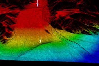
About half way along this imagined march of destruction, at a place called San Gorgonio Pass, the usually clear and distinct path of the San Andreas becomes a confusing mess. Like a hiking trail covered with new fallen snow, the path disappears and reappears. Or maybe it’s more like a bowl of pasta that’s been poured onto the floor. To get technical, the fault changes from a single, right-lateral strand to an intricate network of right-lateral-reverse faults.
The question that has geologists and emergency planners knotted up is can a rupture on one side of San Gorgonio Pass get through this mess to the other side?
“There are something like five or ten diffuse strands [at San Gorgonio Pass],” says Behr. “Are they connected into one at depth? We don’t know the deep fault structure.”
To help determine how connected those little diffuse strands are to the main segments of the San Andreas, Behr is measuring how fast the faults are moving at various points. If the slip rates are much higher to the southeast of the pass than within the pass or northwest of it, for example, that might suggest it’s a kind of structural knot preventing the spread of ruptures. If the slip rates match up, it might suggest a strong connection and a real threat of propagation.
Behr is currently leading a project funded by the Southern California Earthquake Center to measure the slip rate for the San Andreas just 2 kilometers southeast of San Gorgonio Pass. This follows from research she participated in several years ago as an undergraduate research assistant at California State University Northridge. She says studies relating to natural hazards get a lot more attention than most basic research and that the added attention comes with added responsibility.

“You’re really thinking about people’s lives, so you’re a lot more cautious and put a big emphasis on quantifying the uncertainties,” she says.
From Music to Geology
She wasn’t always interested in what’s going on underground. At the end of her first year of undergraduate study at Pasadena City College (PCC), Behr was looking for a way to quickly finish her minimum science requirements so she could get on with the real meat of her degree—music. So she signed up for an intensive two week field course in Baja, California with a biologist and a geologist. The biology majors were fascinated by the critters in the tide pools. Behr found the geology more appealing, especially when the instructor gave her a new perspective on a place she had visited often while growing up with her family.
“There were things I didn’t notice as a kid,” she says. “It made a big impression on me to revisit it and see everything with a scientist’s eyes.”
Before the trip was over, she decided to switch majors to geology.
After transferring to California State University Northridge and completing her undergraduate degree there, Behr went on to the University of Southern California to work on a Ph.D. in structural geology and active tectonics. In addition to working on slip rates and seismic hazards on the southern San Andreas Fault, the last three years of her Ph.D. focused on how rocks deform in the deeper parts of continental plate margins.
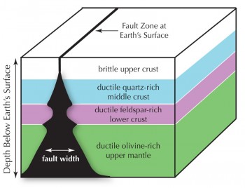
For her dissertation, she tackled two questions that have plagued geologists for decades: First, what’s the relative strength of different layers in Earth’s rocky outer shell, or lithosphere? And second, if you stood on a fault at the Earth’s surface and you could follow it down below your feet, would it become narrower or wider, or would it alternate widths at different depths?
The answers affect how stresses are transmitted from the margin of a continent to the interior and from the base of the continent to the surface. They might also affect earthquake hazards. She conducted extensive field and analytical work along the Whipple Mountains in eastern California and the Betic Cordillera of southern Spain.
In both southern California and Spain, she determined that the middle part of the crust is very strong, meaning it can accommodate high stresses. She’s now assessing the strength of the upper mantle in those areas, which will allow her to determine which of the layers in the lithosphere have the highest strength.

To address the second question, she looked at the Whipple Mountains, where an ancient ductile shear zone, originally formed at depth, is now exposed at the surface. A ductile shear zone is a broad region of rocks warped by parallel forces moving in opposite directions. Behr found evidence that as you go down from the surface, the shear zone remains narrow in the middle crust, but widens dramatically at a depth of 20 to 30 kilometers. Some further theoretical calculations she made suggest that fault zones cutting through continental lithosphere widen to as much as 180 kilometers in the mid-to lower crust, pinch down to just a few meters at the base of the lower crust and uppermost mantle, and then widen rapidly again in the deepest part of the lithosphere.
“My niche is in trying to link field-based geology with geophysics,” she says. “I like to give modelers, seismologists, and experimentalists naturally constrained data that they can use to better tune their models or interpret their observations.”
Field Work in Spain
Completing her Ph.D. in 2011, Behr has continued her work in Spain. Her dissertation research there focused on understanding the strength and character of the middle crust, but since then she’s switched focus slightly to examining crustal rocks that have come up to the surface from much deeper.
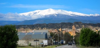
For millions of years, Africa has been moving north, slowly colliding with Europe. Southern Spain is right on the border of this collision. Along this battle zone, continental fragments have been dragged down 60 or 70 kilometers, only to resurface millions of years later, as if riding along on a grand conveyor belt. Behr is trying to understand what these rock fragments were like before this all started, how they got back up to the surface, how fast they came up, and how they changed along the way. She says in some ways, it’s like a mini version of the granddaddy of all continental collision zones, Tibet.
“But it has better wine and beaches,” she says. “We address some of the same problems, but by looking at a smaller area.”
As the two continents approach each other, the lithosphere between them thickens into a heavy block and sinks downward like the goo in a lava lamp. Scientists have suggested that some of that heavy block beneath southern Spain has either broken off or been eroded away by the hotter, convecting material that surrounds it. Behr is part of an international collaboration called PICASSO (Program to Investigate Convective Alboran Sea System Overturn) studying these processes. She has submitted a new proposal to National Geographic to continue this work.
“We’ll do more field work and some geochronology, trying to get the timing of events,” she says.
In addition to the important scientific data she’s collected, she’s learned that geologists in southern Spain do not camp. Actually no one does.
“I suspect if you were discovered wandering on your own and sleeping in a tent, someone would try to offer you shelter in their house,” she says.
Spaniards are also more tolerant of trespassing researchers than Californians.

“In Spain I was frequently doing field work on private property, often without realizing it,” she says. “Rather than people shooting at me and telling me to leave, they would ask me if I wanted a cerveza. It’s a great place to work in that sense.”
After her Ph.D., Behr was a postdoctoral researcher at Brown University for a year. She worked at the university’s world-class experimental rock deformation lab, subjecting ordinary rocks to extreme temperatures and pressures and then comparing them to rocks that had undergone various natural transformations in the mantle. It was a big change from her heavily field-based Ph.D. work.
Now she’s starting her first year as an assistant professor at the Jackson School. She’s currently writing grant proposals, writing up papers from past research, helping students begin their research projects, attending conferences, and preparing to teach two graduate courses this spring.
Behr says one of the big attractions of the Jackson School was its extensive lab facilities.
“As a grad student, I used a lot of analytical tools, but most of them weren’t at my home institution,” she says. “I had to do a lot of networking and traveling to other places to use analytical facilities. It will be a treat to use all these in-house instruments.”
