Small is Beautiful: A New Tool is Helping Identify Potential CO2 Storage Sites off the Texas Coast
January 15, 2013

This past summer, a team of scientists from the University of Texas at Austin completed the first of a series of expeditions in the Gulf of Mexico surveying potential offshore storage sites for carbon dioxide (CO2). In the process, they tested out a new type of seismic instrument designed to reveal geologic layers and structures below the seafloor at shallower depths than those typically surveyed by the oil and gas industry. This additional information is critical, they say, to ensure the CO2 won’t escape back to the seafloor.
The team is currently focusing on a possible geologic storage site in Texas state-owned lands off the southern tip of Galveston Island, about 2 kilometers below the seafloor. Their primary goal is to find sites that can begin to safely and economically store industrial scale volumes of CO2 in the near term. This project is seen as an important step towards what might be the first offshore carbon storage demonstration project in the U.S.
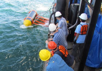
To peer deep below the seafloor, oil and gas explorers troll the oceans aboard ships towing streamers several kilometers long to pick up the echoes of air guns off geologic features below. The Norwegian-designed P-cable marine seismic acquisition system features much shorter streamers (just 25 meters long), in a tighter formation. The result is high resolution 3D seismic imagery in a region extending from the seafloor down to about 1500 meters, shallow by industry standards. Larger sources and longer streamers could eventually be used to image more deeply. By stacking the new shallow data on top of existing industry data from deeper intervals, they plan to reconstruct a history of fluid migration in the region.
“Oil and gas have migrated through these sediments for millions of years,” says Tip Meckel, research scientist at the Bureau of Economic Geology and principal investigator for the project. “If we can tell the story of what happened to those buoyant fluids historically, we think we will be able to tell the story of what will happen to the injected CO2.”
This study, the first in the U.S. to investigate the potential for permanent underground storage of CO2 in offshore geologic formations, is made possible by a $10 million grant from the U.S. Department of Energy’s National Emissions Technology Lab and the Texas General Land Office. Unlike onshore carbon storage, offshore storage has an extremely low risk of contaminating drinking water. Of particular interest to Texas citizens, proceeds from leasing would benefit the State’s Permanent Education Fund, which has been shrinking for decades as hydrocarbon production has declined.

The Jackson School is also the first academic institution in the U.S. to deploy the P-cable seismic system.
“We’re the first to have this,” says Nathan Bangs, senior research scientist at the Institute for Geophysics. “If we do it right, we will be able to get data sets that will enable us to do things that a lot of people can’t.”
The team—Meckel, Bangs, Lorena Moscardelli, research associate at the Bureau, and graduate students Dan Eakin and Mark Duncan—arrived off the southern tip of Galveston Island aboard the R/V Iron Cat in July. (Although he didn’t sail with the rest of the team, the Bureau’s Ramón Treviño is co-principal investigator and project manager.) An important goal of the cruise was to identify shallow faults or other signs of historic hydrocarbon fluid migration to the seafloor, which would indicate how well the overlying geology acts as a seal over the prospective storage interval. During the 15-day cruise, the team shot 1,100 line kilometers of seismic.
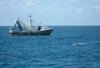
They had the usual challenges of working with a new tool for the first time. They also had to contend with the start of shrimp season. The shrimpers were often pretty distracted, not paying attention to their radios or other ships around them, busily working on their nets. And they weren’t accustomed to the precise patterns of a seismic survey ship scanning back and forth over large swaths of the ocean.
“We mow the grass,” says Meckel. “It’s expensive to go off of a line. It could take six hours to turn around, go back and repeat it.”
Bangs says it was sometimes like a game of chicken with the shrimpers not budging until the last minute. More than once, the ship’s captain had to shoot a flare to get the attention of a shrimper getting too close to the equipment.
Because its streamers are relatively short, the P-cable seismic system is quicker to deploy than other systems and its turn radii are smaller. That means each survey kilometer is faster and cheaper. Its resolution in shallow intervals is also much higher than typical seismic systems, revealing detailed structures they might miss, such as faults with displacements less than a meter. Bangs and Meckel say the potential to start imaging features that have typically been thought of as sub-seismic resolution is exciting.

“Once we’ve worked out the bugs and make this routine, we’ll have a very powerful tool for doing geology,” says Bangs. “To me that’s the exciting thing—doing a large number of these kinds of surveys and having data sets to work on that are like no other.”
Bangs says the P-cable seismic system could be useful in studying faults and fluid migration in regions with the potential to produce large earthquakes such as offshore Tohoku, Japan and Costa Rica. With it, the Jackson School could partner with an oil and gas company to monitor a hydrocarbon production site, taking repeat seismic surveys over time—extending a single 3D survey into 4D—to understand temporal variability in fluid and gas migration and help them assure they are extracting fluids in the most efficient way possible.
Researchers at the Bureau have expressed interest in using the system to study sediment deposits on the Texas shelf over the last few million years and also for imaging modern hydrocarbon reservoir analogs in unprecedented detail. Meckel says the new system could eventually be used to monitor CO2 injections into the subsurface, tracking where the injected gas goes over time.
Texas might be one of the best places in the country to store carbon offshore. The state’s northern Gulf coast has high concentrations of all the essential elements: CO2 emissions, geoscience expertise, and infrastructure. Because state ownership extends 12 nautical miles offshore, compared to three miles for all other states except Florida, the state lands of Texas are among the largest. And thanks to decades of oil and gas exploration, the Texas state lands of the northern Gulf are one of the most geologically studied areas in the world.
The researchers are currently processing the data from the first survey and plan to start interpreting results soon. They plan to publish initial results later this year and to survey another prospective storage site in the subsurface Gulf of Mexico. A third cruise is funded in 2014.
Meckel says he and his team are taking a petroleum systems approach to carbon storage, the same approach that industry uses to understand oil and gas accumulations. Both efforts require the same fundamental geoscience skills. In fact, many of his graduate students end up going into the petroleum industry.
“We’re trying to answer the same kinds of questions,” he says. “Why do fluids migrate? Why do they stop? What processes are involved in their movement and containment? Can we predict performance in structurally complicated areas? If we can predict it, we know where to find oil and gas. If we can predict it, we know where to put CO2.”
by Marc Airhart
