
The Continental Drifter: Ian Dalziel’s Journeys Through Space and Time
August 29, 2011
Ian Dalziel is a jocular and spirited Scotsman. As a boy growing up in Glasgow, he and his parents would spend their summers in the Scottish Highlands. They’d rent a cottage on a windy speck of an island called Iona, which had an ancient stone abbey, puffins, and more sheep than people. You could walk the entire coastline in a day. He wasn’t much of a rock hound, but he did enjoy being out in the open air exploring.

“I went to what turned out to be famous geological localities,” said Dalziel, research professor at the Institute for Geophysics in the Jackson School of Geosciences.
One of them, the Moine Thrust Belt, was among the first known thrust faults, in which older rocks are thrust up and over younger rocks. Geologists postulated that it formed as Europe piled into a stable northwestern foreland that turned out to have been part of ancestral North America, squeezing Scotland to form the Caledonian mountain chain. The only way to make sense of what happened there was through the controversial hypothesis of continental drift, the idea that Earth’s continents move over time.
It was an idea that fascinated Dalziel. In the mid ’50s, he studied at the University of Edinburgh, home of Arthur Holmes, a pioneer in geochronology who had promoted continental drift for years.
“Edinburgh regarded continental drift seriously at a time when it was considered a crackpot idea in the U.S.,” said Dalziel.
The idea had been around for decades, but over the next 10 or 20 years, evidence mounted and, modified by the realization that the Atlantic seafloor was spreading, the hypothesis evolved into what we now know as plate tectonics and became established fact with GPS measurements.
Dalziel, who has devoted his career to reconstructing the ancient geography of Earth through plate tectonics, could hardly have started in a better place. Some of the earliest evidence in support of continental drift came from Scotland. As far back as the 1850s, scientists had recognized that fossil trilobites in northern Scotland were identical to ones found in North America, but not to those from other parts of the world. Likewise, in the early 1900s, identical rock formations were found in both regions. Even stranger, fossil trilobites from southern Scotland matched those from southern Africa.
After completing his PhD, Dalziel joined the faculty at the University of Wisconsin, Madison, which ran a geophysical and polar research center and whose researchers had recently participated in the first grand scientific traverses of the Antarctic made on huge snowcats during the International Geophysical Year of the late 1950s.
It was there that Dalziel realized he could do research in and around Antarctica. Scientists in Wisconsin were trying to understand how South Georgia, a tiny island made up of rock from South America, ended up 2,000 miles away in the Scotia Sea. Dalziel and a colleague went and determined where in South America the island came from. More than 40 years later, he’s still working out the tectonic process that pulled them apart.
More Antarctic MysteriesIn addition to reconstructing Earth before Pangaea, |
Dalziel estimates he has made about 40 trips to the frozen continent, which he said makes him an OAE, or Old Antarctic Explorer. He reckons only one or two other scientists have been there as often. He has been invited to participate in numerous scientific expeditions to Antarctica in part because of his almost encyclopedic knowledge of the geography and geology, as well as how to navigate the bureaucracy of the National Science Foundation’s Office of Polar Programs, which handles funding and logistics for Antarctic researchers. One main thrust of his own research has focused on what other landmasses were once joined to Antarctica in the ancient past.
Before the Before
Most of us under 50 learned in high school that the continents we see scattered across the planet today were once clumped together in a supercontinent that formed around 300 million years ago called Pangaea. Yet Earth is well over 4 billion years old. What was Earth like before Pangaea? It’s a question geologists have pondered since at least the 1930s.
On a field trip to the Transantarctic Mountains in 1987, Dalziel saw rock layers and fossils that seemed strikingly like those of western North America. Previously discovered geological evidence also suggested that sometime before Pangaea, the western margin of East Antarctica had been attached to some other continent and that they then rifted apart. The western margin of North America told the same geologic story. He began to wonder if the two continents were broken from the same loaf.
Leading an Antarctic tour two years later, he shared the insight with Eldridge Moores, a geologist from the University of California at Davis. In 1991, based on Dalziel’s insight and similarities in internal structures discovered by other researchers that suggested strata in southwest Canada had counterparts in southeastern Australia, Moores proposed that the Southwest U.S. was once joined with East Antarctica and Australia within a pre-Pangaea supercontinent called Rodinia. It became known as the SWEAT (Southwest U.S. – East Antarctica) hypothesis.
Using PLATES, a software package developed at UT Austin to position tectonic plates on the globe and reconstruct how they moved over time, Dalziel and Lisa Gahagan, manager of the PLATES project, confirmed that the scale and general shape of the two old rifted margins were compatible. Dalziel became one of SWEAT’s strongest supporters and has spent the last two decades developing and promoting the idea. He’s developed reconstructions showing how, in his view, North America danced its way like a clumsy ballerina from Rodinia to Pangaea, occasionally smashing into a pair of joined-at-the-hip dancers, South America and Africa.
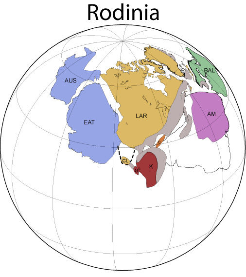
In the time between Rodinia and Pangaea, there were deep ice ages, vast mountain chains formed, and the first multicellular life appeared. Understanding how landmasses and seas were arranged during that time could shed light on the links between climate, environment, tectonics, and life.
The SWEAT hypothesis immediately met with resistance. Competing hypotheses were put forward that put other plates up next to western North America in place of East Antarctica, such as Siberia or South China.
“When we first came out with this idea, I went to a conference and people told me, ‘We’ll start paying attention if you find two things in Antarctica’,” said Dalziel.
One was a type of granite found in a 1.4 billion year old belt of rocks stretching from Newfoundland to California. The other was a type of rock found in a band from Upper Michigan down through the subsurface into the Franklin Mountains of West Texas, in an ancient igneous province called the Kewenawan Province, from about 1.1 billion years ago. If SWEAT was right, some of these rocks should have been left behind in Antarctica.
Full Circle
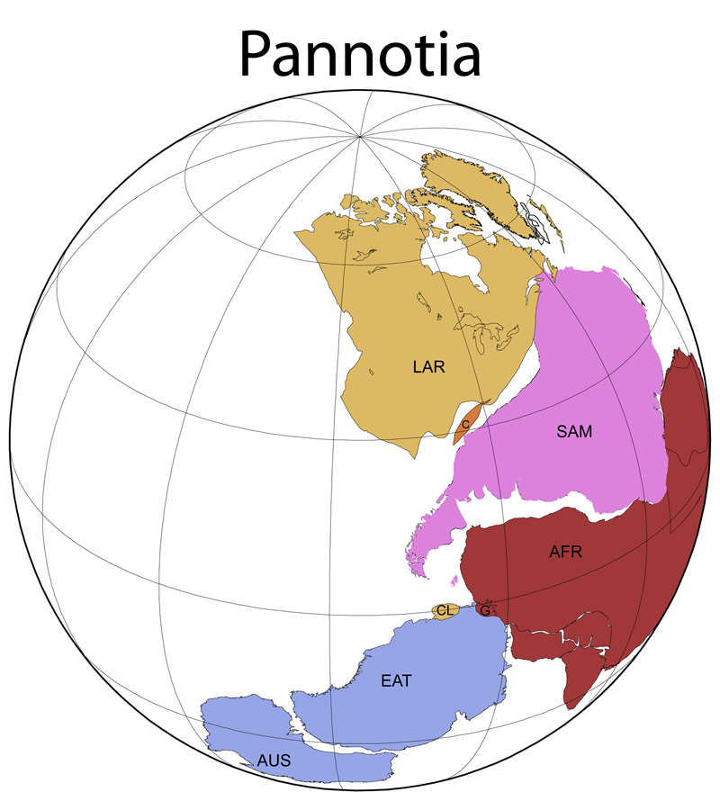
In 2008, John Goodge, a geologist at the University of Minnesota Duluth, announced the discovery of a piece of 1.4 billion year old granite in Antarctica with the same chemical, textural, mineral and isotopic characteristics as a unique belt in North America. More recently, Staci Loewy, a former graduate student who worked with Dalziel, has found that 1.1 billion year old igneous rocks from a part of East Antarctica called Coats Land have identical lead isotope ratios to rocks of the same type and age in the North American Keweenawan Province. That work was recently published in the journal Geology.
“So it looks like Coats Land is a little piece of ancestral North America that came off west of the Grenville Front and is most closely related to the Red Bluff Granite sequence of West Texas,” he said. “It’s a little piece of real estate that is saying ‘North America was here.'”
The irony of finding a bit of Texas in Antarctica is not lost on Dalziel, who left Lamont-Doherty Earth Observatory and Columbia University—after serving as professor, departmental chair and senior research scientist for several years—to come to the Institute for Geophysics in 1985.
“When I came to Texas, I never expected to look at a Texas rock in anger,” he said. “I was hired as somebody who knew a lot about the southern oceans and continents and it turned out that Texas is really important in this story.”
Three of the places most important in his life—Scotland, Texas, and Antarctica—rent asunder by tectonic forces and cast to the winds, are forever united in his digital reconstructions of the ancient world of Rodinia.
Dalziel said like many British kids, he grew up on a constant diet of things Antarctic. He was riveted by heroic tales of Ernest Shackleton’s and Robert Falcon Scott’s attempts to reach the South Pole.
“A hundred years earlier, I could happily have been an explorer,” said Dalziel. “Now the only really worthwhile exploration is scientific exploration. Otherwise I think people are just making projects like ‘Let’s walk along the 110 degrees east meridian.'”
Dalziel will co-lead a three week tour of Antarctica and the Scotia Arc for geologists, naturalists, photographers and explorers at the end of 2012. The tour, sponsored by the Jackson School of Geosciences, will be part of the 125th anniversary celebrations of the Geological Society of America. For details, visit www.cheesemans.com/jsg
by Marc Airhart
Ian Dalziel has been recognized as one of the leading forces in the field of plate tectonics through numerous awards and honors including: Honorary Fellow (Geological Society of London), the Murchison Medal (Geological Society of London), the Clough Medal (Geological Society of Edinburgh), Fellow (Royal Society of Edinburgh), the Bownocker Medal (Ohio State University), and a John S. Guggenheim Memorial Fellowship (Swiss Federal Institute). He has also been recognized within the university for the impact of his research and service through the University Cooperative Society’s Career Excellence Award and the Jackson School’s Joseph C. Walter Jr. Excellence Award, its highest honor.