
Ringside Seat
December 7, 2007
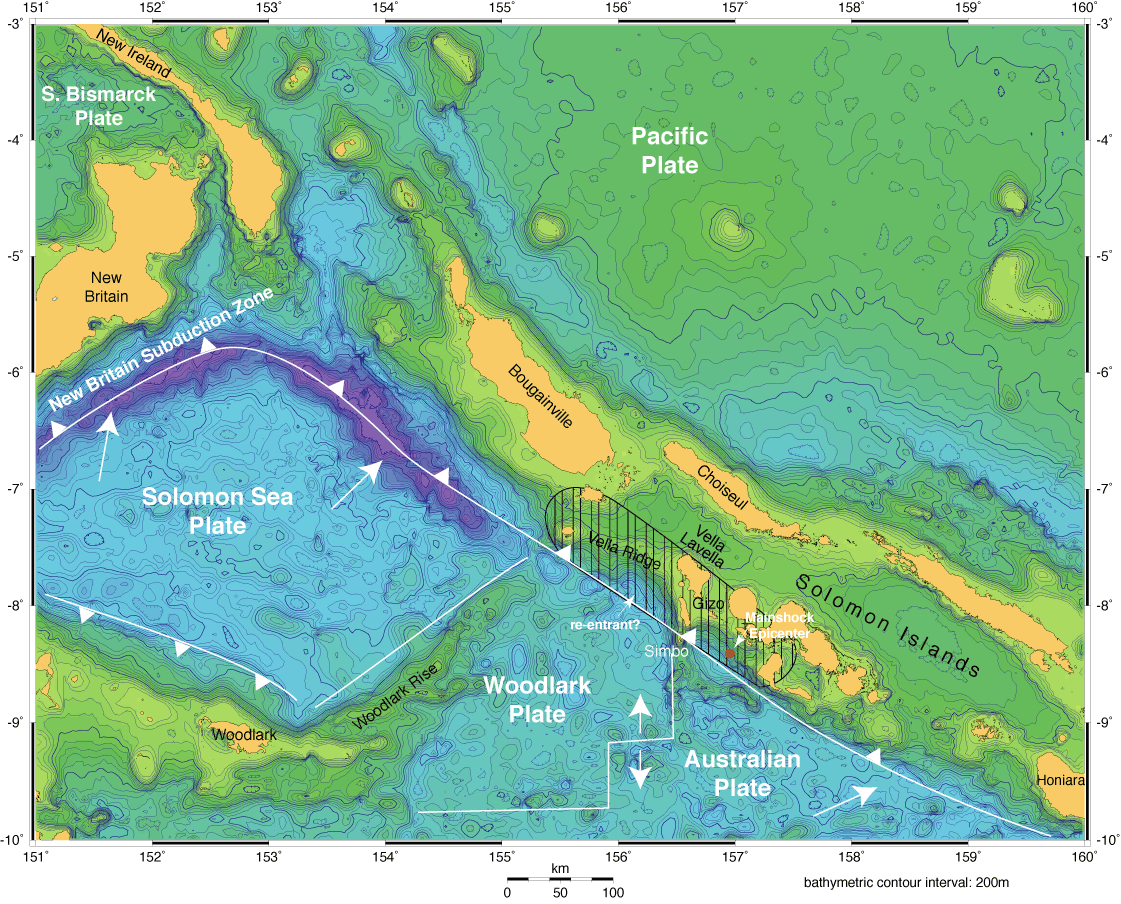
For 20 years, Fred Taylor has done fundamental research in the Solomons, an island arc in the famous Pacific Ring of Fire. The islands trace the underwater boundary where the Pacific Plate, slowly advancing to the southwest, forces three smaller, generally northeast-moving plates down below it, in a process known as subduction. Until recently, Taylor was drawn more by the unique geology and geophysics of the location than the current earthquake risk.
He has tried to better understand how topographic features on the subducting plates, such as ridges and sea mounts, cause the sea floor and island arc to deform. To picture it, imagine you’re lying in bed, watching your feet slide around under the sheets. Why do the sheets look the way they do? What can you tell about the feet by just seeing their effect on the sheets?
Taylor has attempted to understand how and why the interactions of topographic features with the Pacific Plate generate earthquakes. Using fossil coral and other geologic evidence, he showed that there have been a series of uplift events in the area over the past two thousand years that were most likely caused by earthquakes, at least one of which was apparently accompanied by tsunamis.
For Taylor, one of the big selling points for this location is its accessibility.
“There’s something very unusual about this place that you’d have land next to the trench,” he said, referring to the convergent boundary where tectonic plates meet. “Normally this would be underwater. Instead, it’s shallow and uplifted,” he said, because the sea floor being subducted is young, hot, and buoyant.
“You can get out there in places that are normally underwater and make measurements and observations,” he added. “You could put seismometers just a few kilometers over the fault and record the crackling and popping of the subduction at close quarters.” He noted that ocean bottom seismic sensors can be placed at more conventional convergent boundaries, but the cost and technical difficulty are far greater. Drilling down to the fault for direct measurements would also be easier.
“You could drill it with a small drill rig in a few weeks,” said Taylor.
This area is also unique because the plates that converge here are “tightly coupled,” in other words, they are locked together right up to the seabed. According to Taylor, it’s much more common for convergent plates to be stuck together 10 kilometers below the sea floor and deeper.
Cliff Frohlich, associate director of the Institute for Geophysics, is equally impressed with the potential of the Solomons for valuable research. “This may be the only place like this in the world,” he said. “We’re not sure—we’d have to do the search.”
Now that a great earthquake has struck the Solomons and questions remain about the possibility of another big one, Taylor’s choice of research sites seems even more pertinent.
by Marc Airhart
>Back to “Rapid Response Mission Helps Assess Earthquake Risk in South Pacific