
Prepping for Space
October 22, 2014
Jackson School geologist trains astronauts for a trip to the International Space Station and maybe, someday, beyond
By John Williams
In a training room this June at the National Aeronautics and Space Administration’s Johnson Space Center near Houston, members of the new astronaut class huddled around images of the Rio Grande Rift in New Mexico shot from the International Space Station more than 200 miles above Earth. Other black-and-white images, known as hillshaded digital elevation models, have reduced the terrain to resemble little more than a lunar landscape, with spiderweb-like veins denoting the Rio Grande and wriggles and shading indicating mountains and outcroppings.
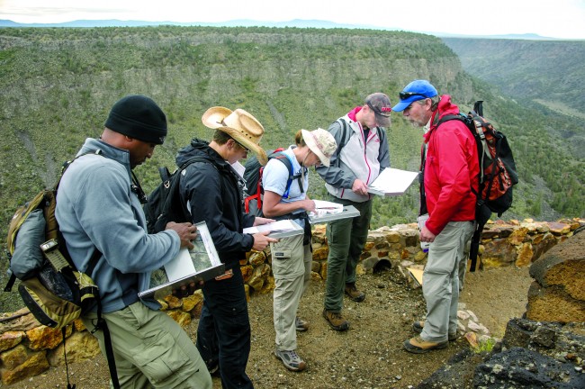
Instructor Mark Helper of the University of Texas at Austin’s Jackson School of Geosciences directed the students—officially known as astronaut candidates—to develop a map that details their understanding of the terrain’s geologic features. The astronaut candidates developed maps not by touching the screens of tablets or laptops loaded with mapping software, but by drawing with colored pencils on plastic overlays atop the photos, each color denoting a specific landscape or rock feature. The following month they journeyed to the New Mexico site north of Taos to see whether their interpretations were correct.
In most cases, they were.
“By and large, the training worked extremely well,” said Helper. “I was impressed by how they were able to pick up so much so quickly.”
Mapmaking with colored pencils? Investigating desert regions on Earth? Is this really part of 21st-century space training? It is—and it is what NASA has determined will help astronauts understand what they’re looking at when they are in the space station’s 400-kilometer perch above Earth, or perhaps one day if we return to the moon—or set foot on Mars.
NASA has trained astronauts in geology since the final Apollo missions of the early 1970s, and Jackson School faculty members have played a leading role in that training. That relationship began with the late Bill Muehlberger, who served as principal investigator for the last two Apollo missions, 16 and 17, in which astronauts carried out significant geological research.
Muehlberger, who trained the astronauts for those Apollo missions, went on to train astronauts for the Skylab and shuttle crews. In 2005 he and Patricia Wood Dickerson, a university Ph.D. who collaborated with Muehlberger in post-Apollo NASA training, invited Helper, who has taught at the Jackson School since 1985, to become involved. Today Helper, a distinguished senior lecturer at the Jackson School, is the lead geology instructor in NASA’s Astronaut Candidate Program.
Understanding What They See
Helper works with Dean Eppler, a NASA senior scientist and geologist by training, to help train future astronauts who one day may be working on the space station. While the astronauts will have opportunities for what Eppler calls “phenomenal observations” of Earth’s features, those observations will have limited value if the astronauts don’t understand what they are seeing.
That is why field geology is part of the training the candidates receive on a variety of subjects, including the space station’s mechanics and life support systems, as well as related courses in space physiology, medicine and Russian (a practical consideration given the close coordination between the American and Russian space agencies for traveling to and from the space station). With candidates having to absorb a massive amount of knowledge and skills within a couple of years, Helper likens the process to “drinking from a fire hose.”
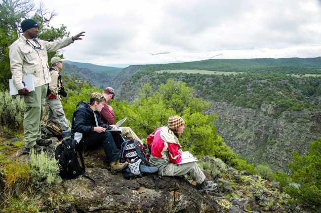
For this summer’s class, Helper and his training team selected a site in the Taos Plateau Volcanic Field of the Rio Grande Rift near the confluence of the Rio Grande and Red River. The area is part of one of Earth’s major rift zones, regions that exhibit the results of shifting tectonic plates that formed present-day continents, oceans, mountain ranges and volcanoes, as well as other outcroppings and features that reveal much about the earth’s geologic history.
NASA’s use of the Rio Grande Rift dates back to the days of Apollo training. The region is a favorite for geologic training because the geology and landscapes are in some ways analogous to the moon. The features are relatively young (mostly less than 10 million years), so they are less affected by the vagaries of erosion, and deep gorges and canyons provide a view of what is below the surface.
Helper designed his instruction to allow his students to get the most out of their brief time with him. During classroom instruction, the astronaut candidates reviewed and discussed geologic features, then paired off with instructors over satellite and space-station imagery of a 10-by-14-kilometer (6.2-by-8.7-mile) section of the field site. Using colored pencils on plastic overlays atop their 11-by-9-inch photos, the candidates defined and labeled the site’s topographic and geological features, outlining what they perceived to be the site’s various rocks and sediments.
By tracing, shading and labeling the site’s features, the candidates learned how to establish the history of a field site, Helper explained. The variety and layers of rock and sediment can tell much about the order of events that led to the geology we see today. Gravel layers and some basalt flows near the bottom of the canyons date from earlier times, while talus and “modern” sediment that overlie them are more recent.
The challenge for the candidates was to unravel the sequence and timing of rock layer formation—the “geologic layer cake,” as Eppler puts it—and of land form development to produce testable hypotheses about the site’s evolution. This summer, the candidates traveled to New Mexico to compare their maps and ideas with the actual site.
Simple Is Better
The hand-drawn maps reflect Helper’s hands-on, learning-by-doing teaching style that he believes provides much more productive learning opportunities.
“It’s a much simpler way to work,” he said.
If color pencils on a plastic overlay seems low-tech compared to laptops and tablets, Helper said there is a plus side: “You don’t have to worry about batteries losing power or wasting limited, precious field time on hardware and software issues.”
This was Helper’s second class. Graduates of his class in 2010 are currently serving aboard the space station, and others are scheduled to serve. The classes are small—14 candidates (including two each from the Canadian and Japanese space agencies) in the 2010 class and eight this summer.
Culled from a pool of thousands of applicants, the candidates—mainly engineers, scientists and aviators—are selected on the basis of the skill sets NASA believes it will need for its next mission. The current candidates are scheduled to complete their training in July 2015.
Training in geology will take on increased importance if NASA is able to return to the moon, which has not hosted human visitors since Apollo 17 lifted off from the lunar surface in December 1972. That return depends on the agency’s ability to muster political support and funding to build the kind of spaceship that can carry astronauts to an asteroid or back to the moon—and allow them to stay there longer for more extensive research. If that phase is successful, future goals will likely include the landing of an exploration team on Mars—a longstanding dream of scientists to go beyond the limited capabilities of the two robotic rovers, Spirit and Opportunity, currently on the planet.
Field experiences like the astronauts’ exploration of the Rio Grande Rift will be especially valuable in such endeavors. The rift’s rocks and record of volcanic activity, Helper explained, “are analogous to what we expected to see on the moon,” and its sediment fill “is similar to what we expect to see on Mars or other planetary surfaces.”
Whichever planet they visit, astronauts “will not have an infinite amount of time to explore or unlimited storage to bring back all the rocks they find,” Eppler explained. “So they will need to prioritize”—specifically, identifying those features on the planets’ surface such as the ridges, canyons, volcanic cones and rock outcroppings that, like the features in the Rio Grande Rift, offer the greatest potential for revealing how the planet formed.
The astronauts being trained by Helper and his associates “may not be going to the moon or Mars, but they’re gonna be in charge when we do,” Eppler predicted. That means the earth-based, pencil-on-plastic training being conducted by Helper will be influencing current and future space explorers for generations to come.
Back to the Newsletter