
How Underground Sensors in Texas Will Help NASA Predict Drought and Floods
November 25, 2014
Stanley Rabke’s family has lived and worked on their Hill Country ranch since 1889. Generations of Rabkes have struggled with the extremes of Texas weather, but one storm sticks out in Stanley’s memory: it came after the drought of the 1950s.
“It rained and rained and rained,” he says. “Back then we raised turkeys, we lost thousands of turkeys that washed away in the creek.”
The disaster underscores an irony of life in Texas. “You hope and pray that you’re going to get a good rain, [but] on the other side of it, you hope you don’t get a flood,” says Rabke.
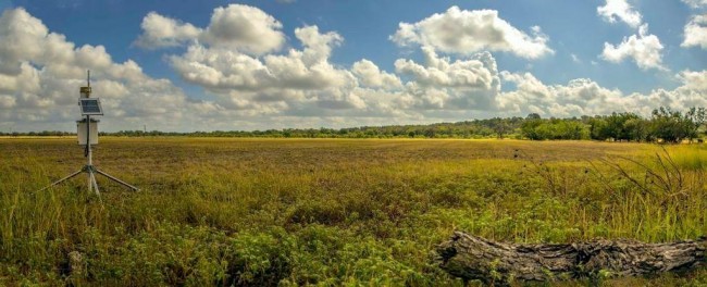
A quick walk from where the turkeys met their fate, some new technology that will help manage that risk is being installed — soil monitoring sensors in the ground.
Dr. Todd Caldwell and his team have dug a pit and they’re connecting wires and setting up a tripod monitoring station, but they’ve run into some trouble.
“You see the sensors have about a 15 centimeter-long tine that’s thin metal, and we have to push those into the clay when it’s dry. This is kind of set up like a concert,” Caldwell says. “So, we have to push really hard to get them in, so we’re struggling a bit right now…”
The tines measure the how much water is in the soil. That information travels on buried wires to the tripod. It gathers more data. then it feeds it on a cellular network back to the landowner, and then to the University of Texas. That’s where Caldwell works, at UT’s Bureau of Economic Geology.
NPR’s StateImpactTexas, November 25, 2014
Featuring: Todd Caldwell, research associate at the Bureau of Economic Geology, and Michael Young, associate director of environmental systems at the BEG