Every Last Drop
November 17, 2026
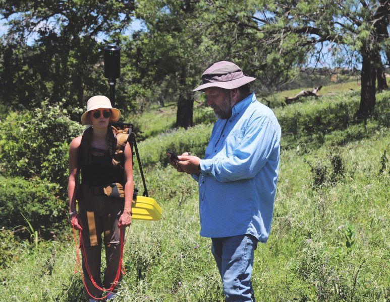
Stepping methodically across an overgrown hillside near the Guadalupe River, undergraduate Terin Score keeps her eyes straight ahead, guided by the rope in her hand. On her back is a space-age-looking electromagnetic sensor; researcher Ben Grunau carries a matching system about 50 paces ahead.
They are trying to see what lies beneath their feet — bedrock, clay, fractures and the hidden pathways through which water moves underground.
What’s happening underground matters here because during drought, the Guadalupe can disappear into cracks and seeps just a few miles from Canyon Lake and enter the Trinity Aquifer. Some of that water is believed to eventually reemerge in the lake, which supplies tens of thousands of residents. Here’s the rub: No one is really sure how much of the water flows into the lake and how much stays in the aquifer, where it can be tapped by the local wells of Comal County residents.
In wet years, the uncertainty is easier to live with. During drought, amid rapid population growth and increasing pressure on Texas water supplies, it becomes much harder.
“We have to understand how much water is flowing through the river, where the water in the river is coming from, and where that river water is going,” said Will Eagle, a 2026 Jackson School graduate who helped teach students in the Hydrology Field Camp this summer. “To effectively manage water resources, you have to understand how much water is in your system and where it’s going.”
The mystery of the Guadalupe is a microcosm of the challenges facing water managers and communities across the state. And water issues are expected to become more intense during the coming decades as Texas’ population is projected to grow 53% between 2030 and 2080 — from 34.2 million to 52.3 million — and large industries continue to grow. At the same time, the Texas Water Development Board expects the state’s water supply to shrink due to groundwater depletion and increased sedimentation in Texas reservoirs.
These are issues that Longhorn hydrologists — professors, students and researchers alike — work every day to address. For generations, the Jackson School of Geosciences has trained hydrologists by putting them to work on real water problems. Today, as Texas faces growing pressure on its water supplies, that combination of field education, research and public service is more important than ever.
“It’s really important that we continue to train these water resource professionals and conduct the science that is really critical to Texas,” said Daniella Rempe, the Jackson School’s associate dean for research and a hydrology professor.
Planting Seeds in the Field
Jackson School students don’t simply practice field techniques. They use them to help answer real questions about Texas water.
In fact, the effort to understand where the Guadalupe River was losing water began in 2019, when Jackson School students conducted fieldwork in partnership with the Comal Trinity Groundwater Conservation District. Their measurements helped quantify that 20,000 acre-feet of water per year was entering the aquifer directly from the river. The results were significant enough to launch a larger research effort focused on understanding recharge and improving the assumptions used in water planning.
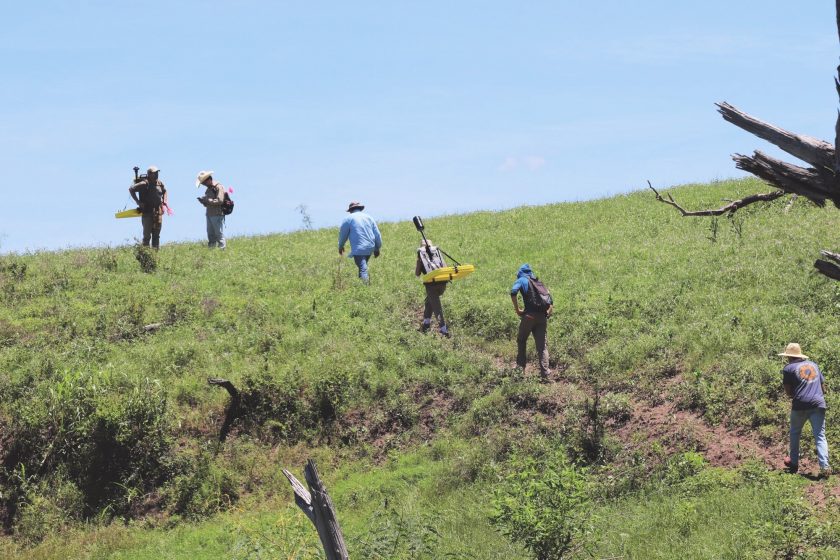
That effort was led by Research Associate Professor Marcus Gary, who has spent a professional lifetime helping manage Texas water.
Gary earned his doctorate from UT before the Jackson School was formed. He has built a career studying Texas water. Garyworked at the U.S. Geological Survey and served as principal geoscientist for aquifer science at the Edwards Aquifer Authority. He began teaching as an adjunct professor at the Jackson School in 2011, leading critical field training in the hydrology program, and joined the school full time in March 2025.
Gary’s connections to state and local water agencies reflect the Jackson School’s deep ties to water management across Texas. He can rattle off the names of former students working throughout the state in important water-planning roles in the public and private sectors.
Logan Schmidt, a Jackson School alumnus and principal geoscientist at the Edwards Aquifer Authority, is among those former students. Schmidt returned to hydrology field camp this summer to teach students, including Score, how to use electrical resistivity tomography — a method he also employs in his professional research to image conditions below the surface.
Schmidt remembers conducting similar fieldwork as a student with Gary and admits that he did not fully understand its significance at the time. Now, he understands how those hands-on experiences can stay with students.
“We’re planting little seeds. Maybe in the future some of them will germinate, and they’ll kind of be like, ‘Yeah, I remember doing something like this,’” he said.
For Score, some of those seeds are already taking root. She entered field camp nervous and unsure about whether she belonged in the field. The experience pushed her toward research she had previously hesitated to pursue.
“I felt like it forced me to dive into research skills that I had always wanted to do, but I never really had pushed myself to do,” she said. “Now I’m looking to incorporate that more openly than I was before.”
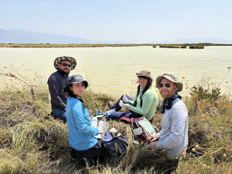
During four days, Score and her fellow students approached the mystery of the Guadalupe from above and below ground. They measured the volume of water moving through different sections of the Guadalupe, sampled river and well water, recorded water levels in 16 wells, and used geophysical instruments to image differences in the rock, sediment and moisture beneath the riverbanks.
Their clearest result came at River’s Bend, where two teams working simultaneously measured the river upstream and downstream of about a half-mile reach. Flow fell from about 45.5 cubic feet per second to 25.5 cubic feet per second — a loss of approximately 20 cubic feet per second. The reach crosses a mapped fault in the fractured, permeable limestone of the Middle Trinity Aquifer, supporting the idea that faults and other karst features provide pathways for river water to move underground. The team could not trace that water to its ultimate destination, but the loss closely matched earlier surveys that repeatedly identified the same stretch of river as a recharge area.
The results are encapsulated in a 134-page report “Hydro Field Camp 2026 Guadalupe River, Comal County, Texas” that is posted on the UT Hydro Hub (see page xx ).
The experience changed not only how Score thought about field research, but also how she understood its value. She was struck by how eager the landowners were to see the data that she and her classmates collected on their properties.
“Talking to those landowners and seeing how much they cared about their county and their river and their water made the experience for me,” she said.
Data to Information
Measurements like those collected along the Guadalupe are the foundation of water management. But individual measurements become far more useful when they can be combined with other data to reveal how an entire water system is changing.
That presents another challenge. Texas has accumulated an enormous amount of water data through state and local agencies, but much of it is fragmented and difficult for decision-makers — who usually are not water experts — to find, combine and put to use.
Justin Thompson and his team at the Jackson School’s Bureau of Economic Geology are working to bridge that gap. They have integrated a wide variety of water data from 24 counties across the Texas Hill Country into a single platform that transforms the data into accessible and actionable information. The result is a layered picture of what is happening to water at any location in the Hill Country at an unprecedented scale.
The platform, called the Water Exploration Terminal (WET), is free and open to the public. It uses publicly available data from state and local water agencies and ties together data on surface water and groundwater with precipitation, evapotranspiration, soil moisture and atmospheric variables such as temperature and wind speed. Users can animate maps through time and generate time-series graphs with trend lines on the fly for the Hill Country or for specific areas of interest.
“There’s data — that’s stuff researchers can work with — and then there’s information, which is what stakeholders and policymakers can work with,” Thompson said. “The idea is to grab all of this data, put it in one place, and transform it from data into information.”
That information can be broad or very specific and deep, depending on the user’s needs.
For example, while the current water planning process produces detailed projections, they are often communicated in broad averages for a region. The WET can narrow that to an area as small as 1 square mile. This means that instead of seeing only a projected average aquifer drawdown of 50 feet across an entire region over 50 years, a user can zoom in on a specific location. There, the projected drawdown could be as little as 5 feet — or more than 100 feet.
Thompson started with the Hill Country but would like to expand the system to all parts of Texas, a plan that will depend on available funding.
“We chose the Hill Country because it’s booming. It’s growing like mad, and it’s already a water-stressed area,” he said.
Tools such as the WET and the Hydro Hub can make complex water information accessible. But producing that information — and understanding what it means — requires hydrologists who are taught to see how geology, climate, chemistry and human development interact.
That systems-level approach is a defining feature of hydrology education at the Jackson School.
Molding Hydrologists
Water does not fit neatly within a single scientific discipline. Understanding it requires students to connect geology with a huge number of other disciplines.
That is the strength of the Jackson School’s approach, Rempe said: It teaches students to understand the whole hydrogeologic system and the forces acting upon it.
The Jackson School has a hydrology and water resources major, but many of the hydrology skills are also taught in the school’s environmental science and geosystems engineering programs.
The goal is to create systems thinkers — students who know fundamental physical and chemical principles but can also cope with the complexity and interactions of real environments.
It’s really important that we continue to train these water resource professionals and conduct the science that is really critical to Texas.
Daniella Rempe
Students encounter that complexity early in GEO 416W “Climate, Water, and the Environment,” where controlled experiments meet the messiness of real-world data.
In one exercise, students create a watershed in the lab, simulating rainfall and streamflow with bottles and buckets, and using paper towels as a fill-in for the soil. The following week, students analyze streamflow and precipitation patterns at real-world research sites and use scientific literature to determine whether their experimental results make sense in natural settings.
This pairing of fundamental science with real-world data is a theme throughout the degree.
“The idea is that when you go out and you’re actually standing on the ground and there’s an aquifer beneath your feet, how the heck do you make sense of what might happen to the water in the future?” Rempe said.
Field camp is where those different strands of the curriculum — and the school’s emphasis on systems thinking — come together. During three weeks, students move beyond classroom diagrams and controlled exercises and confront the uncertainty of actual water systems. They must decide where to take measurements, how to deploy instruments, and what their findings mean.
Instructors deliberately give them room to make those decisions — and sometimes to make mistakes, said Dan Alessi, an aqueous geochemist and Jackson School hydrology professor. Even the faculty do not always know what the data will reveal.
“They have the opportunity to work on live field research projects,” he said.
That experience also gives students an advantage when they enter the workforce. By graduation, they have worked with wells and field instruments, collected water samples, carried them through quality-control procedures, analyzed the results, and presented their findings.
“It makes them eminently more employable because they’re just much more literate,” Alessi said. “It’s not a hypothetical PowerPoint slide thing for them. They will have experienced it.”
The need for those skills is only growing. Alessi said every student he has advised in geochemistry and hydrogeology — at both UT and the University of Alberta, where he was previously a faculty member — has either found professional work or continued in academia. Graduates go on to consulting companies, water utilities, groundwater districts, government agencies and research institutions — often taking on significant field responsibilities early in their careers.
Score and her classmates are the newest additions to a professional community the Jackson School has been building for years.
Professor Emeritus Jack Sharp has helped build that community for more than four decades. Since joining UT in 1982, he has advised about 100 graduate students, including Gary, and taught hundreds more, including Rempe and Thompson. Today, a professional network he maintains includes about 600 people, many of them former students working in water consulting, government, groundwater management and academia.
For Sharp, their collective reach matters because the water problems they are being taught to address are becoming more difficult — and more consequential.
“I think we’re going to have real problems, but we have the tools to solve them,” he said. “UT is helping to pave the way by pioneering research and training the next generation of water professionals. We have to continue giving the people of Texas the best information we can about how to manage this precious resource, without which we cannot live.”