
Study Explores How Tectonic Forces Shape The Andes
October 27, 2022
Based on their shared geologic history, one would expect the topography of the Andes mountains to be relatively consistent from one end to the other. But reality defies expectation: the 8,000-kilometer long mountain belt spectacularly widens and narrows (varying from 300 to 900 km in width) as it winds from north to south along the western edge of South America.
In search of answers that could help explain these undulations, researchers carried out a simple exercise — measuring the distance between tectonic features and topographic changes over 150 transects across the mountain belt. It revealed that multiple tectonic drivers appear to shape the mountain range as it exists today.
“There’s been a difference of opinion on what the drivers are: What’s controlling the extent of mountain building and the width of the zone of compressional deformation,” said lead author Brian Horton, a professor with a joint appointment in the Department of Geological Sciences and Institute for Geophysics at The University of Texas at Austin Jackson School of Geosciences. “Our work demonstrates that there are multiple answers.”
The study was published in Geology. It was co-authored by Tomas Capaldi, an assistant professor at the University of Nevada, Las Vegas, and Nicholas Perez, an associate professor at Texas A&M University. Both Capaldi and Perez earned their doctoral degrees from the Jackson School’s Department of Geological Sciences.
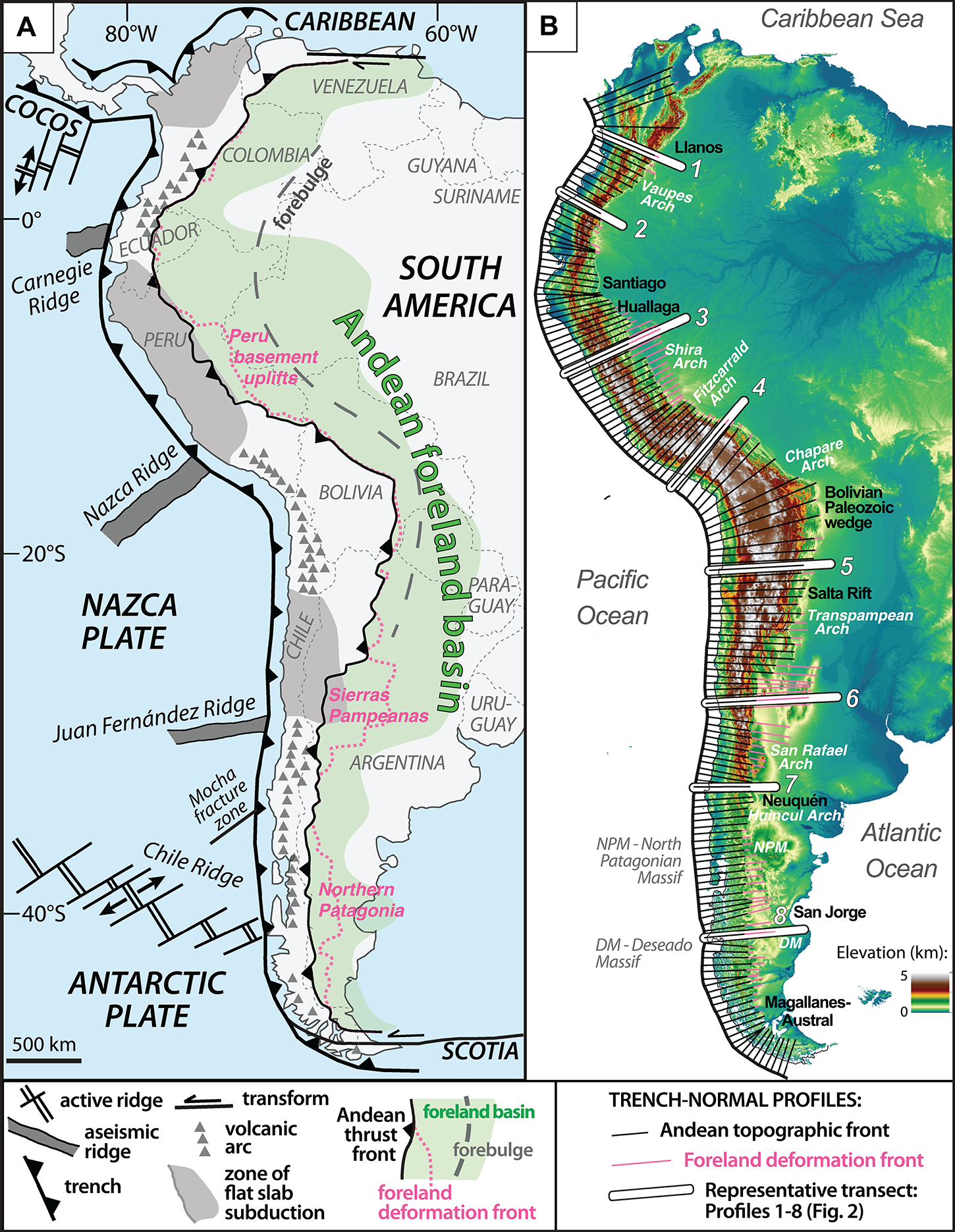
Geoscientists agree that a subduction zone offshore of the west coast of South America somehow promotes mountain building in the Andes. The oceanic Nazca plate dives beneath the South American plate, creating a trench in the seafloor and generating the compressive forces that build mountains. However, Horton said that there’s a great debate over how these tectonic forces affect the width and topography of the Andes. What’s more, some geoscientists think that pre-existing geologic features left behind by earlier tectonic activity — so-called “tectonic inheritance” — could play an important role too.
To help tease out the connection between geology and tectonics, the researchers created multiple profiles (or cross-sections) using GIS software and satellite data, then measured the topography, relief, and distance between the subduction trench and the deformation front marking the eastern edge of the Andes. They also observed how structural and stratigraphic features changed along the Andean mountain front.
“We’re trying to understand these perturbations in the deformation front,” Capaldi said. “By observing satellite imagery and geologic maps we were able to pinpoint where the topography of the Andes ends and where the non-deformed foreland basin begins.”
The study focused on three major tectonic influences active in the Andes: perturbations in the subducting oceanic plate involving flat slab subduction and ridge subduction; and tectonic inheritance in the overriding South American continental plate.
They found that areas of flat slab subduction and ridge subduction were associated with widening of the deformation zone. Inherited tectonic features were associated with both widening and narrowing. For example, thick Paleozoic stratigraphic wedges appeared to encourage mountain building, whereas thinner Mesozoic rift basins inhibited it.
Although the study focused on spatial connections, the researchers said that this is the first step to more in-depth investigations of how mountains grow during subduction.
The researchers said that the technique could be used around the world to help uncover connections between tectonic activity and mountain building — both modern and ancient.
“We can look at the Andes to understand modern processes,” said Perez. “We can also use our understanding of today’s Andes to consider the tectonic evolution of other places on Earth at other times in Earth history.”
Adolph Yonkee, a professor at Weber State University who is an expert on mountain building processes in North America and South America, said that the study accounts for a diverse array of geological data and enables scientists to examine potential tectonic connections at play.
“The study does an excellent job of bringing together observations of deformation styles, relations to the primary crustal architecture, and connections to plate margin geodynamics,” said Yonkee, who was not involved with the research. “These different aspects are interrelated, but vary among different mountain systems, and this study will promote further studies and debate.”
The study was supported by the National Science Foundation.
For more information, contact: Anton Caputo, Jackson School of Geosciences, 210-602-2085; Monica Kortsha, Jackson School of Geosciences, 512-471-2241.