
2021 Research Highlights
December 29, 2021
It was another great year for research at the Jackson School of Geosciences! Let’s look back on some highlights:
UT Austin Teams Up With City and Community to Fight Extreme Heat in Austin
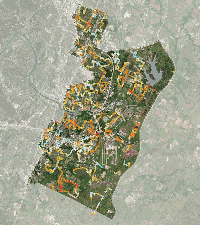
In June, The University of Texas at Austin announced that is partnering with the City of Austin, community groups and East Austin residents to find out where hot temperatures are affecting people the most — and proposing solutions to cool down these places. Jackson School Professor Dev Niyogi is the project lead. >> read more
Austin Partners with UT to give City Lakes a Health Checkup

In September, The University of Texas at Austin and the City of Austin gave Lake Austin and Lady Bird Lake a first-of-its-kind health checkup, scanning the lakebed CT scans and taking algae biopsies. The checkup investigated thickening algal mats linked to sediments washed in by severe flooding. It will support the City of Austin’s routine water quality and harmful algal sampling efforts. Marcy Davis, an engineering scientist at the University of Texas Institute for Geophysics (UTIG) is the project co-lead. >> read more
Gulf Coast Ready to Develop Carbon Storage Hub
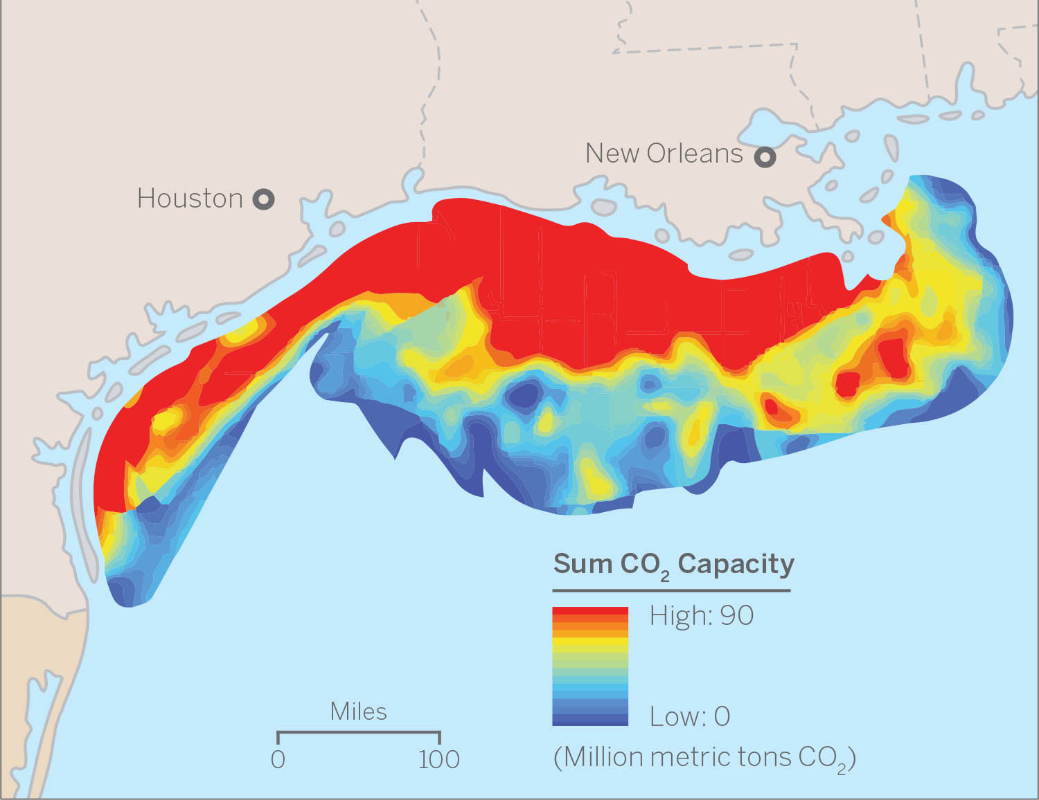
In May, members of the Gulf Coast Carbon Center at the Bureau of Economic Geology published a paper in Greenhouse Gases: Science and Technology providing a high-level overview of policy incentives for carbon capture and storage and how Texas and Louisiana’s high concentration of industry and unique offshore geology make the region a particularly good spot to build up a carbon storage economy. The paper was authored by Senior Research Scientists Tip Meckel and Susan Hovorka, Research Scientist Alex Bump and project manager Ramón Treviño. >> read more
UT Researchers Pushing Innovative Solution at DOE’s Hydrogen Earth Shot Kickoff
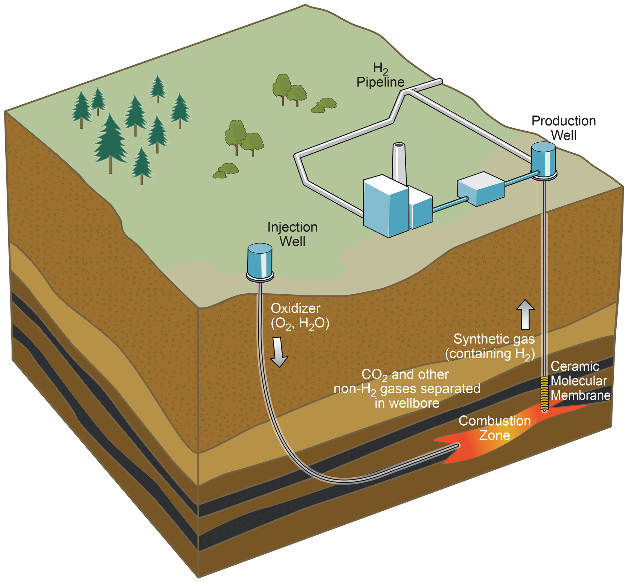
On August 31 and September 1, researchers from The University of Texas at Austin presented their plan for turning untapped oil into clean hydrogen energy via an innovative combination of of in-situ combustion and carbon dioxide storage. Research Scientist Ian Duncan, the director of the Earth Systems and Environment group at the Bureau of Economic Geology, is leading the research. >> read more
Study Offers Plan to Overcome Hurdles for Hydrogen Energy

In May, a research team from The University of Texas at Austin analyzed what it would take to scale up the use of hydrogen, including integrating hydrogen into the country’s natural gas system. The research presents an initial goal of replacing 10% of the nation’s natural gas supply with hydrogen as a reasonable first target. That move could reduce U.S. greenhouse gasses by 3.2%, based on 2019 emissions, and help meet the Department of Energy’s goal of enabling a low-carbon economy in the U.S. Mark Shuster, associate director of energy at the Bureau of Economic Geology in the UT Jackson School of Geosciences, led the research. >> read more
UT Begins Offshore Search for Sand Resources to Protect Texas from Coastal Erosion

On April 14, Scientists from The University of Texas at Austin embarked from Galveston in search of sunken treasure that holds the key to protecting Texas from storms and rising seas: sand. The scientists are assisting the Texas General Land Office in locating the sand needed to restore and reinforce the state’s beleaguered beaches and build a formal sand inventory for Texas. Senior Research Scientist John Goff is leading the effort. >> read more
Mars’ Surface Shaped by Fast and Furious Floods from Overflowing Craters

In September, Nature published a study presenting evidence that massive floods from overflowing crater lakes had an outsized role in shaping the ancient Martian surface, carving deep chasms and moving vast amounts of sediment. Assistant Professor Timothy Goudge led the research. >> read more
World’s Largest Pterosaur Leaped Aloft to Fly
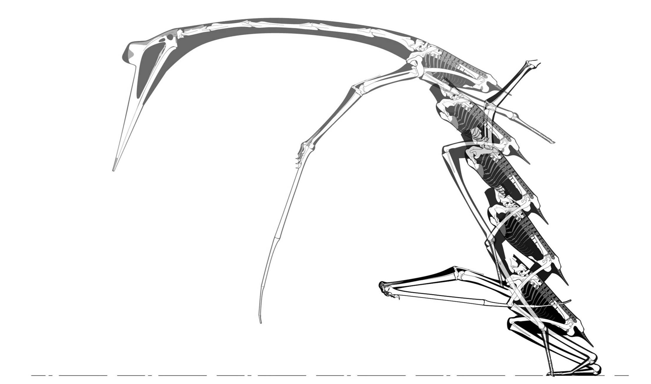
Credit: Kevin Padian et al / John Conway
In December, The Society of Vertebrate Paleontology published the most comprehensive study of the giant pterosaur Quetzalcoatlus, the largest known flying animal to ever live. The study presents a new species, details on how the pterosaurs’ lifestyle and habitats, and how they likely took to the air by leaping. The study was co-edited by Matthew Brown, the director of the vertebrate paleontology collections at the Jackson Museum of Earth History. >> read more
Top Geology Award Goes to Ian Dalziel of the Jackson School of Geosciences

In October, the Geological Society of America awarded Jackson School Professor Ian Dalziel with the Penrose Medal for pioneering discoveries about Earth’s ancient geography and its past supercontinents. Established in 1927, the Penrose Medal is widely considered to be geology’s most prestigious career award. >> read more
Tracking Water Storage Shows Options for Improving Water Management During Floods and Droughts
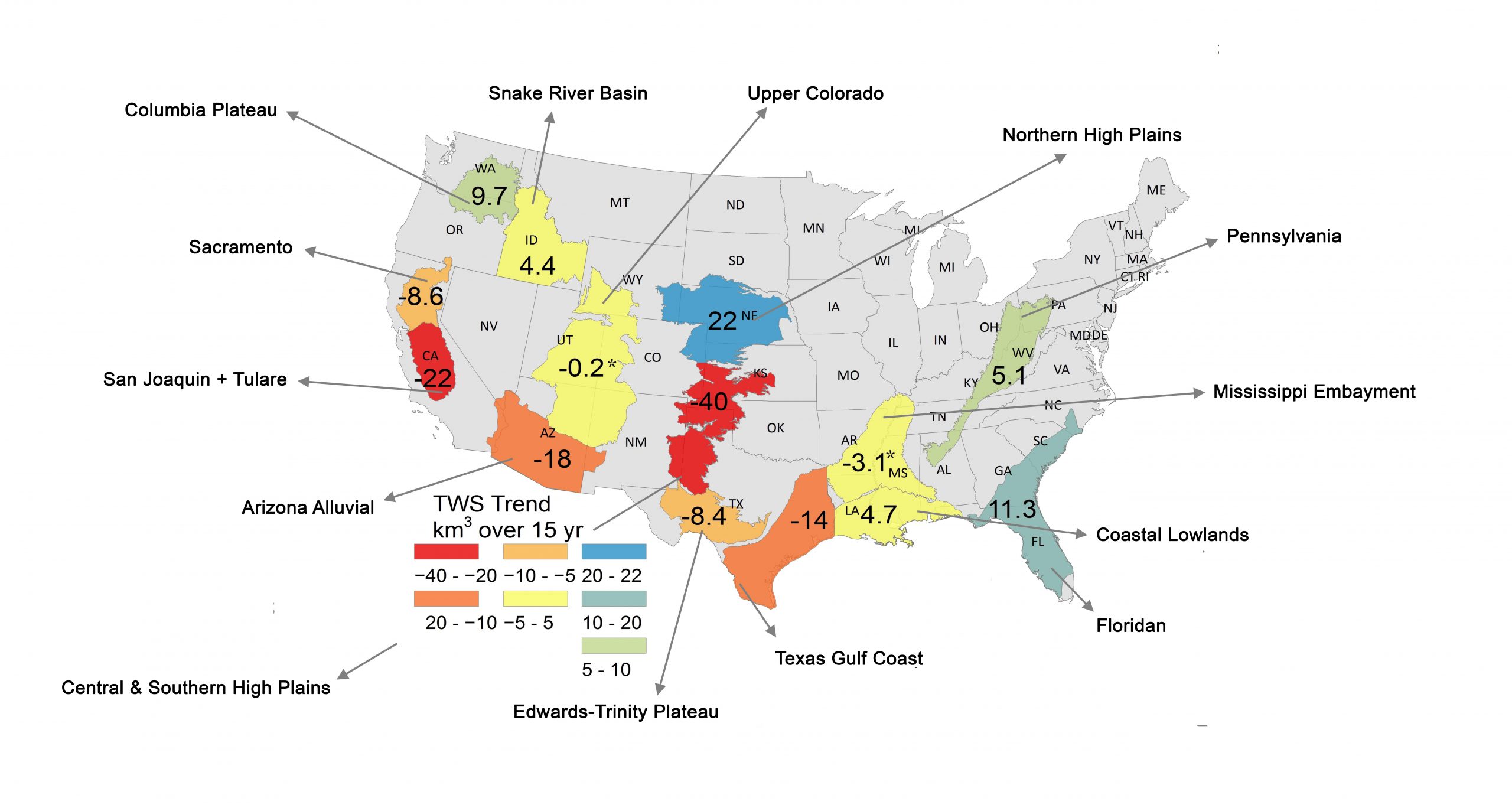
In August, researchers at the Bureau of Economic Geology created a balance sheet for water across the United States – tracking total water storage in 14 of the country’s major aquifers over 15 years, with the research examining the interplay between irrigation habits and climate on water. The research was led by Senior Research Scientist Bridget Scanlon. >> read more
For more information, contact: Anton Caputo, Jackson School of Geosciences, 512-232-9623; Monica Kortsha, Jackson School of Geosciences, 512-471-2241.