
Natural Methane Linked to Groundwater in Parker and Hood Counties
November 20, 2017
Scientists from the Jackson School of Geosciences have found that high levels of methane in well water from two counties near Fort Worth are probably from shallow natural gas deposits, not natural gas leaks caused by hydraulic fracturing operations in the underlying Barnett Shale.
The research, published in the journal Groundwater in March 2017, builds on previous studies on well water quality in the Barnett Shale, and uses chemical and geographic evidence to tie the elevated methane level in certain water wells to methane in natural shallow deposits.
The research was led by J.P. Nicot, a senior research scientist at the Bureau of Economic Geology. Collaborators include Toti Larson, a researcher from the Jackson School’s Department of Geological Sciences, and scientists from the University of Michigan.
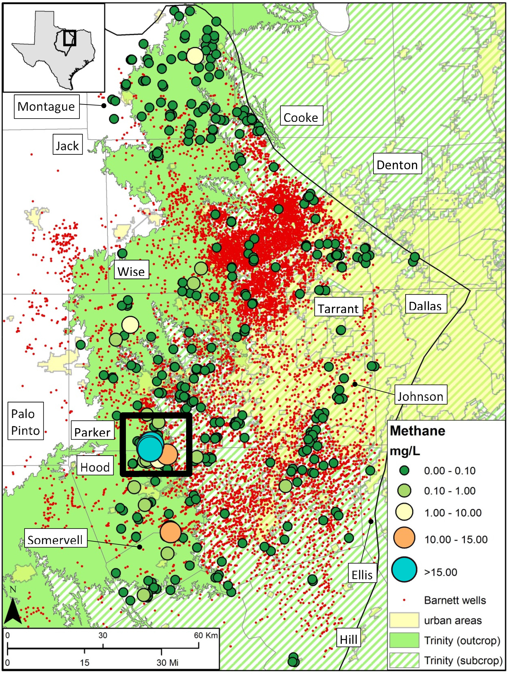
The Barnett Shale, located in the Fort Worth region, is one of the largest and most productive natural gas fields in the United States with about 20,000 wells. As production has boomed, questions have been raised about the connection between hydraulic fracturing and potentially dangerous levels of methane in some water wells, most notably wells in the Silverado neighborhood in Parker County.
The researchers analyzed samples from more than 450 wells across 12 counties in the western Barnett Shale. About 85 percent showed very low methane levels in the groundwater of less than 0.1 milligrams of methane per liter of water. However, a cluster of 11 wells in the vicinity of the Silverado neighborhood had methane levels above 10 milligrams per liter of water, a level that can trigger venting of well water systems to ensure the flammable gas does not become hazardous. These 11 wells are found in a roughly 6-by-8- mile area that also includes wells with low levels of methane.
Researchers used carbon isotope analysis to determine that the methane was thermogenic, which ruled out biogenic sources but didn’t pinpoint whether the gas came from the deeper Barnett or a shallower reservoir in the study area called the Strawn Group.
Additional analysis of the samples’ noble gases conducted by members of the same research team and led by University of Michigan researchers linked the methane to the natural gas deposits of the Strawn. The results were complemented by another of the team’s studies in 2015 that found nitrogen isotopes associated with the Strawn.
“Combining alkane, noble gas and nitrogen compositions, and isotope ratios allowed us to distinguish natural gas sourced from the deep Barnett Shale from the shallow Strawn Group,” Larson said.
Back to the Newsletter