
Haiti still at risk of large earthquake
January 12, 2011
A year ago Wednesday, one of the five deadliest earthquakes in recorded history struck the island nation of Haiti.
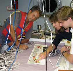
Paul Mann, a senior research scientist at the university’s Institute for Geophysics (UTIG) and expert on Caribbean tectonics, was there just weeks after the quake to study the geological causes and determine what, if any, risks remained for more quakes. He and his colleagues from around the world have learned a lot, but the work is far from over.
Writer Marc Airhart caught up with him to get an update on what we know, and still don’t, a year on.
Airhart: Right after last year’s deadly quake, it was assumed that it was the Enriquillo-Plantain Garden Fault (EPGF) that ruptured and caused the quake. You and several of your colleagues published papers in October in the journal Nature Geoscience which came to a very different conclusion, right?
Mann: We proposed the amount of stress released on the EPGF was either very small or was non-existent based on the recognition that another nearby fault to the north, the Leogane fault, released 80 percent of the energy in the earthquake. The other 20 percent of energy release occurred on other fault planes which may or may not have included the EPGF. What that means is that there was little or no relief on centuries of accumulated stress on the EPGF during the 2010 earthquake. The main trace of the EPGF is still primed and ready to go during a major quake, as it was prior to January 2010.
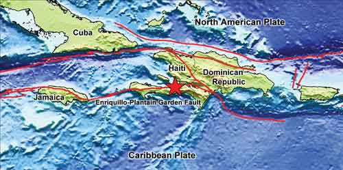
You and others forecast back in 2008 that the EPGF was primed for a large earthquake near Haiti’s capital. So in some ways, aren’t Haitians back where they started?
Yes, since the amount of stress reduction from the January 2010 event is small, the EPGF stores the same amount of accumulated stress as it did before. But the story doesn’t end there. Our fieldwork after the earthquake showed that one of the large 18th century earthquakes that destroyed Port-au-Prince previously was larger than magnitude 7.0 but probably smaller than magnitude 7.6. This shows that the EPGF remains a likely source for future earthquakes of this size magnitude in the Port-au-Prince area. Our work also showed that in the earlier quake, the fault ruptured all the way up to the ground surface; but in the January 2010 quake it didn’t. The question then became, why not? There are two schools of thought. One is that there are two completely separate fault systems — the EPGF and a previously unknown thrust system to the north (now called the Leogane fault). The second, which is the camp I’m in, is that the EPGF is a broader zone of deformation directly linked deep underground to the Leogane fault. In the latter scenario, the EPGF might have released some amount of stress during the 2010 event and thereby reduced its threat to the Port-au-Prince area.
How can that debate be settled?
We need to have better seismic imagery of the fault at depth. It’s like having high quality X-rays to make a diagnosis of a sick patient. Seismic surveys done by Matt Hornbach, Sean Gulick and others after the quake only penetrated the upper tens of meters of the sediment cover. We need to image much deeper given that the hypocenter of the quake was 13 kilometers beneath the Earth’s surface. These images will answer fundamental questions about the fault geometry: are there two separate fault systems (EPGF and Leogane) or are both faults linked as part of a single, wider fault zone? Unfortunately, their proposal to the National Science Foundation was turned down but they will keep trying.
As they rebuild, do you think the Haitian government and citizens are taking seriously the threat of another big quake?
The problem is that we can’t predict when a future earthquake will happen. If we could “predict” and provide a specific date for a future large quake, then governmental officials and planners would sit up and take note. Because we can’t, the threat of future earthquakes tends to slide to the bottom of the governmental priority list behind more pressing matters like building permanent housing for over a million people and dealing with a cholera epidemic that now affects thousands of people.
You proposed to the National Science Foundation a research project where you would drill cores in lake sediments around Haiti to create a timeline of past earthquakes in the region. That was rejected too. How would that project have helped?
Those lakes record the history of large earthquakes in the Port-au-Prince area going back tens of thousands of years at a very high resolution. If there’s any sort of regularity in that pattern, that’s a powerful tool. It’s like a drumbeat of earthquakes. You want to know what that beat is. For example, maybe there is one every 250 years or every 300 years. This type of information still doesn’t allow us to predict earthquakes (a quake will occur on a certain day and year), but it does allow us to make improved forecasts of future events (there is a certain probability that a quake of a certain size will happen within a certain time frame).
by Marc Airhart
Also See: