
Hunting Hidden Glaciers: The Search for Mid-Latitude Ice on Mars
May 9, 2010
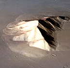
Scientists reviewing images of the surface of Mars transmitted to Earth by the Viking orbiters in the 1970s were puzzled by mountains and cliffs surrounded by gently sloping deposits of rocky material. In some cases these deposits, called lobate aprons, extend tens of miles. For three decades, scientists have debated how these features formed and what lies beneath the surface.
One theory contended they were flows of rocky debris lubricated by a thin layer of ice. The features reminded Institute for Geophysics researcher Jack Holt of massive ice glaciers detected under rocky coverings in Antarctica, where he has extensive experience using airborne geophysical instruments such as radar to study ice sheets. If correct, it would indicate much larger deposits of water ice. But using radar to look for buried ice is notoriously tricky.
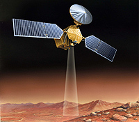
In August 2005, NASA launched the Mars Reconnaissance Orbiter (MRO), designed in part to probe beneath the surface for evidence of subsurface layering, water and ice. Holt was selected to be on the SHARAD team in early 2007. With its Shallow Subsurface Radar (SHARAD) instrument, scientists finally had the tool to help solve the mystery.
Titanic Discovery
Members of the science team, scattered around the world, propose regions of Mars where they would like to acquire radar data with SHARAD. Limitations of computer storage on the satellite and bandwidth for sending data back to Earth make it impossible to collect data 24/7. In weekly teleconferences, the researchers decide when and where new data will be collected. Holt selected “target boxes” that included some of these lobate aprons in the mid-latitudes of the southern hemisphere.
The SHARAD instrument sends out pings, short bursts of radio waves, straight down to the surface where some reflect back up and others penetrate into the subsurface and reflect from deeper layers of rock, dust or even water ice. As they pass through different materials, the waves change. They speed up or slow down and, like the distorted image of a straw in a glass of water, the waves refract, or bend their path. The nature of the return signals—when they arrive, how strong they are, and how their properties change in transit—can reveal much about the surface and subsurface. Once the data are collected and transmitted back to Earth, engineers process them to reduce noise and boost the true signals before passing them on to researchers.
| Separated at Birth
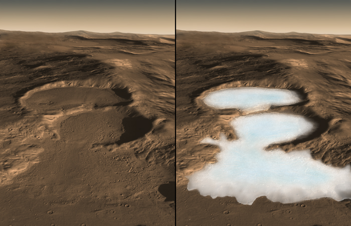
It turns out that the newly discovered deposits of water ice on Mars, called lobate debris aprons, are very similar to rock covered glaciers in Antarctica.
|
In early 2008, the SHARAD instrument collected data from three separate orbits that crossed over one of Holt’s target boxes with lobate aprons. Colleagues at NASA’s Jet Propulsion Laboratory working on processing the data and aware of the potential to settle the long-standing debate, took a sneak peek before sending them on to Holt for his analysis. They were excited to find evidence suggesting the aprons might actually be vast glaciers of water ice lying beneath protective blankets of rocky debris.
Holt wasn’t so sure. He knew that a type of noise called surface clutter could mimic features in the subsurface. He and a student were developing a computer simulation that could help differentiate this type of noise from true subsurface features. Holt had developed such a tool for radar sounding in the Dry Valleys of Antarctica, but applying it to Mars meant major changes to the algorithm. The possible discovery spurred them on to get the simulator working with the precision needed to make that assessment.
Eventually, the simulator confirmed that surface clutter was not responsible for the apparent water ice. The discovery of glaciers was real.
Because water is one of the primary requirements for life as we know it, finding large new reservoirs of frozen water on Mars is an encouraging sign for scientists searching for life beyond Earth.

The concealed glaciers extend for tens of miles from edges of mountains or cliffs and are up to one-half mile thick. A layer of rocky debris covering the ice may have preserved the glaciers as remnants from an ice sheet covering middle latitudes during a past ice age.
“Altogether, these glaciers almost certainly represent the largest reservoir of water ice on Mars that’s not in the polar caps. Just one of the features we examined is three times larger than the city of Los Angeles, and up to one-half-mile thick, and there are many more,” said Holt, lead author of a report on the radar observations in the Nov. 21, 2008 issue of the journal Science.
“In addition to their scientific value, they could be a source of water to support future exploration of Mars,” said Holt.
Show Me the Water
“These results are the smoking gun pointing to the presence of large amounts of water ice at these latitudes,” said Ali Safaeinili, the SHARAD Instrument Scientist with NASA’s Jet Propulsion Laboratory in Pasadena, California.
The radar’s evidence for water ice came in multiple ways. The radar echoes received by the orbiter while passing over these features indicated that radio waves pass through the apron material and reflect off a deeper surface below without significant loss in strength, as expected if the aprons are thick ice under a relatively thin covering.
| Cut the Clutter
Surface clutter, a type of noise in radar data, is a real pain in the neck. An undergraduate student worked with Holt to develop a way to tell surgace clutter from water ice.
|
The radar did not detect reflections from the interior of these deposits as would occur if they contained significant rock debris. Finally, the apparent velocity of radio waves passing through the apron was consistent with a composition of water ice.
Developers of the SHARAD instrument had the mid-latitude aprons in mind, along with Mars’ polar-layered deposits, long before the instrument reached Mars in 2006.
“We developed the instrument so it could operate on this kind of terrain,” said Roberto Seu of Sapienza University of Rome, leader of the instrument science team. “It is now a priority to observe other examples of these aprons to determine whether they are also ice.”
“We developed the instrument so it could operate on this kind of terrain,” said Roberto Seu of Sapienza University of Rome, leader of the instrument science team. “It is now a priority to observe other examples of these aprons to determine whether they are also ice.”
How Did It Get There?
The buried glaciers reported by Holt and 11 co-authors lie in the Hellas Basin region of Mars’ southern hemisphere. The radar has also detected similar-appearing aprons extending from cliffs in the northern hemisphere.
“There’s an even larger volume of water ice in the northern deposits,” said the Jet Propulsion Laboratory’s Jeffrey J. Plaut, whose paper on that discovery was later published in the journal Geophysical Research Letters. “The fact that these features are in the same latitude bands—about 35 to 60 degrees—in both hemispheres points to a climate-driven mechanism for explaining how they got there.”
The rocky-debris blanket topping the glaciers has apparently protected the ice from vaporizing as it would if exposed to the atmosphere at these latitudes.
“A key question is, ‘How did the ice get there in the first place?’” said James W. Head of Brown University.
“The tilt of Mars’ spin axis sometimes gets much greater than it is now, and climate modeling tells us that ice sheets could cover mid-latitude regions of Mars during those high-tilt periods,” said Head. He believes the buried glaciers make sense as preserved fragments from an ice age millions of years ago.
“On Earth,” said Head, “such buried glacial ice in Antarctica preserves the record of traces of ancient organisms and past climate history.”
by Marc Airhart (with excerpts from NASA press release by Guy Webster)
Also See:
Scientists Discover Concealed Glaciers on Mars at Mid-Latitudes (2008 Press Release)
For more information about the Jackson School contact J.B. Bird at jbird@jsg.utexas.edu, 512-232-9623.