
Troubled Waters: Mexican Desert Springs Face Uncertain Future
January 3, 2009
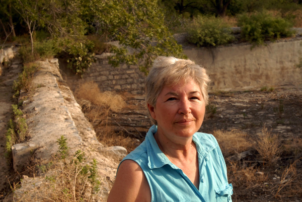
Lourdes Ferriño says the land around her bed and breakfast was once full of life. Castilian roses grew out front next to the road that leads into the village of Cuatrociénegas. Her family sold the blooms to a company in Mexico City for perfume. Closer to town, the family’s winery cultivated their own grapes. A spring-fed stream ran through the valley and through her family’s mill, which she has spent the last decade converting into a rustic bed and breakfast.
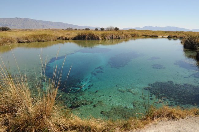
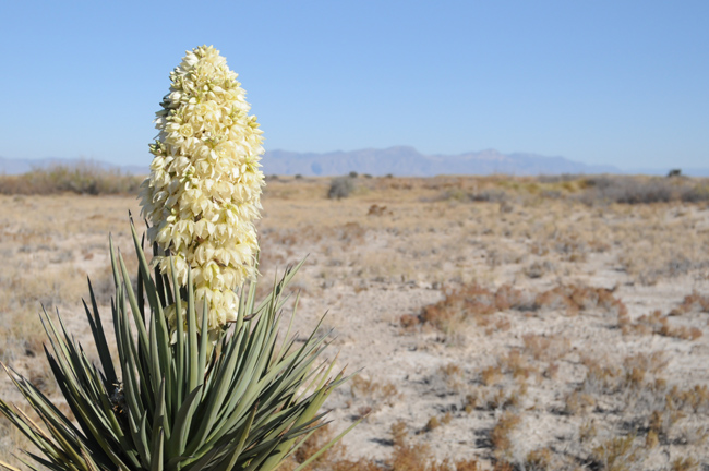
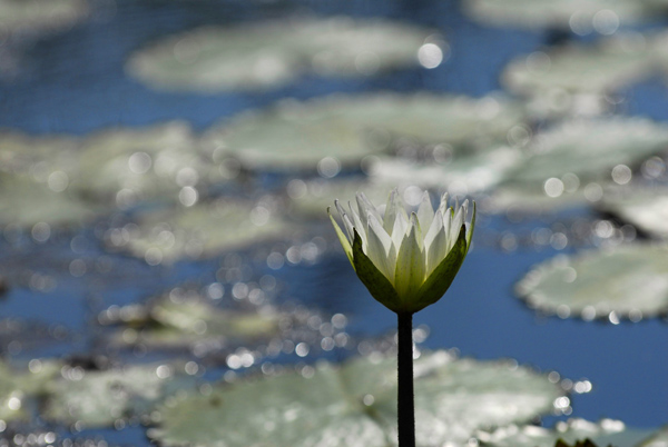
After driving hours through northern Mexico’s Chihuahuan Desert, visitors to Cuatrociénegas (which means four marshes) still sense they are entering a special place. Here, on a valley floor studded with white gypsum sand dunes and ringed by mountains, hundreds of springs emerge from the ground filling blue-green pools, streams and rivers. Communities of microbes build rocky freshwater reefs in the warm, mineral rich water. Fish, turtles, shrimp, clams, snails, lizards and snakes found nowhere else in the desert, or the world for that matter, thrive here. With over 70 such endemic species, it is often compared to the Galapagos Islands. The World Wildlife Fund ranks it as one of the three most “biologically outstanding” desert freshwater ecoregions in the world.
But there is also a sense that like the desert mirage it appears to be, this oasis might evaporate in an instant. That the closer you get to it, the more it might fade into sand, cactus and bones.
View Audio Slideshow: Troubled Waters
Mirage?
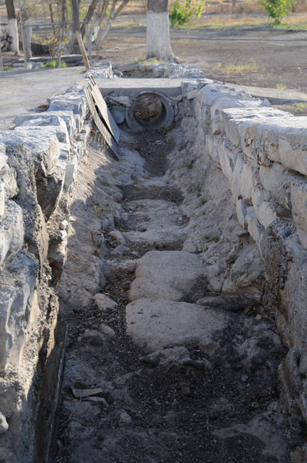
Today, the roses are long gone. The Ferriño winery imports its grapes. And the stream that once provided drinking water for the village of 11,000 people, irrigated pecan, apricot and fig orchards—and many years ago turned the mill stones that ground wheat and corn for local farmers—completely dried up last year.
The changes in the valley don’t end in the village. Scientists who have carefully studied the water on and under the valley floor also see troubling signs. The water table is falling and the surface is drying out. A Texas hydrogeologist and his students visiting last March reported that one of two spring vents that feed Poza Azul, one of the area’s showcase pools, had stopped flowing. A biologist who has made observations there for decades said he has never witnessed that before.
No doubt some of the changes have resulted from the diversion of springs and streams via canals to water small scale farms over the past two centuries. Climate change might also be causing some drying out. But now there is growing concern among local villagers and scientists from Mexico and the U.S. over a relatively recent arrival in the region—large scale agribusiness.
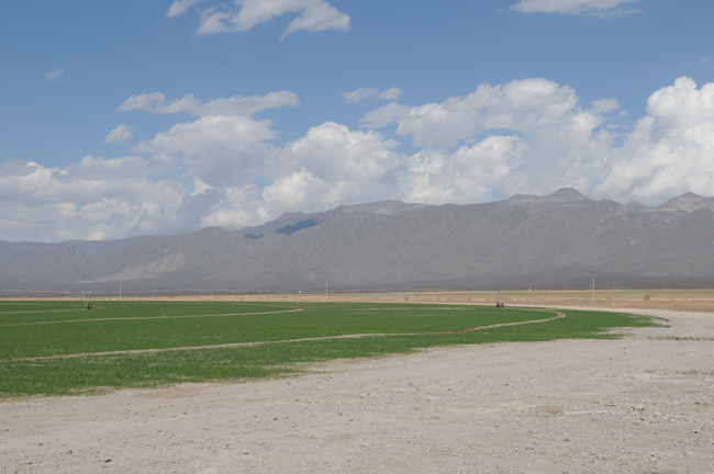
In the mid 1990s, Grupo LaLa, Mexico’s largest dairy, bought land in the Ocampo Valley north of Cuatrociénegas and drilled deep water wells to irrigate fields of alfalfa for their cattle. Cartons of LaLa milk can be found on grocery store shelves and breakfast tables across Mexico. Soriana, a Mexican grocery and department store chain, also began groundwater extraction for farming.
Visitors driving into the Ocampo Valley today might be surprised to see windswept gypsum sand give way to lush green carpets watered by modern center pivot irrigation systems. It’s as if a wormhole had opened up in the fabric of space-time, plucked up an Idaho farm and dropped it in the middle of the desert.
In the Ocampo Valley, the ground water level has fallen by tens of meters and springs have dried up since the pumping began. LaLa representatives claim that the groundwater they are pumping is not connected to the Cuatrociénegas ecosystem. Indeed the two valleys are separated by the Sierra La Madera mountains, which some experts think could form a barrier to underground flow. A study published in 2005 by researchers at Instituto Mexicano de Tecnología del Agua, an agency of the Mexican government, concluded that all spring flow in the Cuatrociénegas Basin (CCB) originates as precipitation falling on the surrounding mountains.
Yet observations of water levels, disappearing springs, anecdotal evidence from villagers, and recent research by scientists at The University of Texas at Austin—including hydrogeologist Brad Wolaver and fish biologist Dean Hendrickson—and elsewhere cast doubt on those interpretations.
Local or Regional?
In many ways, the struggle to manage water in Cuatrociénegas is the same one that is playing out in arid environments around the world including Texas, California and the entire Southwestern U.S. The question is how to best manage a limited resource among diverse competing interests—in the case of Cuatrociénegas, small scale farmers, big business, local villagers, tourists, scientists and a rare ecosystem surviving on a knife’s edge.
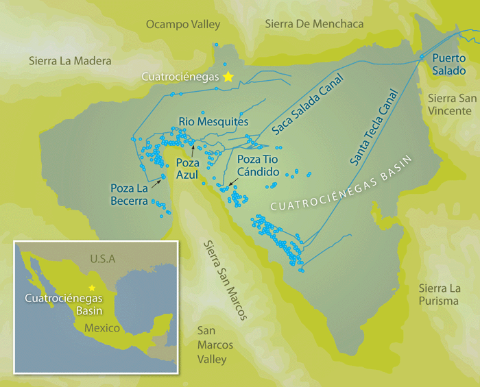
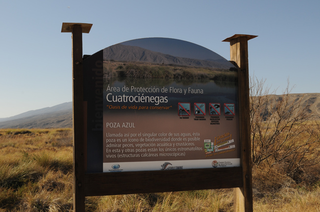
The Mexican government designated the basin an Área Protegida Natural de Flora y Fauna (a National Protected Area for Plants and Animals) in 1994. The protections curiously didn’t extend to the groundwater below the CCB, much less nearby valleys. Some scientists, conservationists and residents worry that wells in adjacent valleys are sucking water from the same limited underground pool, or aquifer, that feeds the springs.
Mapping the size and shape of an aquifer—and the recharge zone, or overlying land that funnels water into it—is no easy task. But it’s a critical step in efforts to protect the springs.
Brad Wolaver, at the time a doctoral student working with hydrogeologist Jack Sharp at the Jackson School of Geosciences, set out to determine the size of the recharge zone required to produce the spring flow in the CCB. To tackle the problem, he used a broad suite of tools and techniques that he says could be applied to better understand and manage regional groundwater systems in arid environments around the world.
Wolaver used a handheld device called an acoustic Doppler velocimeter to measure the discharge in two human built canals that drain part of the springs, including the largest spring in the basin (Poza La Becerra). He took this combined discharge as a conservative measure of the total discharge from hundreds of springs in the basin. He determined that more than 35 million cubic meters of water are discharged by the springs per year. That accounts for output, but what about input?
To fill in the other side of the balance sheet, he estimated that 3 percent of the rain that falls on the 4,000 square kilometers (or approximately 1 million acres) of the CCB and surrounding mountains would have to be absorbed to produce that much discharge. Could the CCB realistically hold on to that much rainfall?
The valley floors have a thick layer of caliche, hardened deposits of calcium carbonate that do not readily absorb water. So most rainfall and runoff in the valleys evaporates or is transpired by plants. Therefore, local recharge comes almost entirely from the meager mountain rainfall of about 40 centimeters per year. Based on analogous sites in West Texas and Nevada, he estimated that only about 1 percent of that mountain rainfall could be expected to escape evaporation in the dry climate. In other words, it would take several times the land area of the CCB and surrounding mountains to account for the discharge of just two springs in the system.
“The water is not being recharged locally,” says Wolaver. “It’s being recharged regionally. And that means pumping for agriculture in adjacent valleys can impact the springs.”
Time Lag
Other lines of evidence bolster Wolaver’s analysis. For example, he used a second technique to estimate recharge in the mountains using chloride levels in precipitation and in the springs. The technique, which has been successfully applied to the Great Basin of Nevada and other arid and semiarid regions, indicates a regional source of recharge over 10,000 square kilometers in area.
Wolaver also demonstrated that the mountains separating the CCB from the Ocampo Valley to the north and the Hundido Valley to the southwest do not pose a barrier to the flow of groundwater as some researchers have suggested. There is increasing concern about Hundido Valley because in 2003, ranchers drilled more than 100 wells there and established 10,000 hectares of new alfalfa fields. Mexico’s National Commission for Water has set limits on water pumping in the Hundido Valley, but the limits are very high. Since pumping started about 25 years ago, the water table has declined more than 20 meters.
The discovery that the mountains do not pose a barrier to groundwater flow was made using an analytic model that incorporated a digital elevation model (a three-dimensional map of the landscape), measurements of the hydraulic head (a combination of water pressure and elevation) on either side of the mountains, and the transmissivity of the rock (its ability to transmit water).
Major funding for Wolaver’s research came from the Jackson School of Geosciences, Tinker Foundation, Houston Geologic Survey, Geological Society of America, Gulf Coast Association of Geological Societies, BHP Billiton and Sandia National Laboratory.
Even the smallest life forms on Earth, microbes, point to a regional aquifer that includes nearby valleys.
Valeria Souza, an ecologist at the Universidad Nacional Autónoma de México, carried out a genetic analysis of microbes in water from the CCB, Hundido Valley and another adjacent valley. She found that 90 percent of the most abundant microbial lineages were found in all of the sample sites. She and her co-authors in a 2006 paper in the journal Proceedings of the National Academy of Sciences concluded that the three valleys are connected by a deep aquifer that allows migration of microbes.
“Our microbiological data, along with the low hydrologic recharge of the superficial aquifers and geologic structure of the region indicate that serious concerns are warranted regarding the impacts of regional water extraction on the unique ecosystems in the CCB and nearby valleys,” the researchers wrote.
Perhaps even more unsettling, Wolaver’s work demonstrates that the water that feeds the springs takes at least 50 years to recharge, maybe much longer. Samples of spring water taken in 2007 showed extremely low levels of tritium, a byproduct of radioactive fallout from atomic bomb tests in the 1950s and 60s. That indicates that the water that feeds the springs hasn’t been in contact with the surface for at least as long.
If the aquifer is pumped dry and the springs cease flowing tomorrow, it may be decades before any meaningful restoration could take place. Even then it would be little comfort to the dozens of extinct plant and animal species, as well as small-scale farmers who rely on spring discharge to irrigate their crops.
Humans and the Springs
The basin’s stark beauty and diversity of life attract an increasing number of tourists each year. According to an article in the Austin American Statesman in March 2008, the annual number of tourists who have visited the region doubled from 25,087 (in 2001) to 50,941 (in 2007). Nowadays, during Holy Week leading up to Easter, tourists and locals alike crowd shoulder to shoulder into the few remaining pozas and streams that are open to the public. The Mexican government has plans to develop the valley into an even bigger year-round tourist destination.
In some parts of the world, tourists have been instrumental in preserving endangered ecosystems by raising awareness and bringing money into the local economy, providing an incentive for locals to protect natural resources. Such an ecotourism industry has yet to take root in Cuatrociénegas.
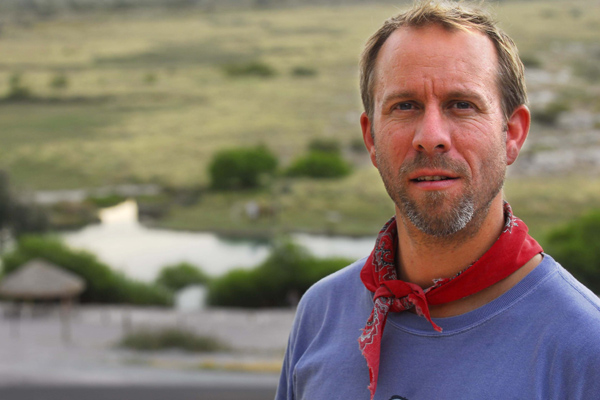
Dean Hendrickson, a fish biologist at the University of Texas at Austin who first visited Cuatrociénegas as a graduate student in 1979, says many local villagers simply aren’t aware of what is in the valley and why it is so unique.
“Many of them have never explored the valley, except maybe to swim in Poza La Becerra,” he says, referring to a popular spring-fed public pool. “There was a huge river, the Rio Garabatal, with a huge marshland. It dried up in the 1970s. Ninety nine percent of the people in Cuatrociénegas don’t know it ever existed.”
“Maybe they remember grandpa talked about going fishing there, but the fact that it was even there is lost,” he continues. “Even people working in the reserve, they came from the outside, so their experience only goes back 10 years at the most. So in their vision, they think we have to save what was there 10 years ago. So that shifting baseline is a hard thing to battle.”
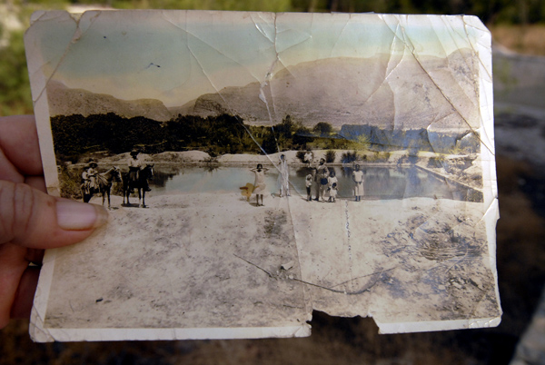
He’s compiled a series of photos from decades ago and compared them to the same spots today. The changes are dramatic. But, he stresses, photos only tell part of the story.
Some local families, such as that of Lourdes Ferriño have lived and farmed here for more than a century. They have seen the changes first hand. When it came time to divide up the family land among several relatives, Ferriño, a hard working woman with glasses and an easy smile, picked the old mill.
“I chose the mill because I like the sound of the water,” she says. Rio Cañon, the stream that originated as springs in the Ocampo Valley and spilled over a saddle shaped mountain pass into the CCB, once filled a 1 meter wide pipe. It supplied the village’s drinking water and powered the mill. A dusty scar snaking across Ferriño’s yard is all that remains of the stream. The village has been forced to drill its own water wells, in search of ever deepening water.
What will become of Ferriño’s bed and breakfast? Will tourists continue to visit if the springs dry up too?
Living Laboratory
For now, scientists continue to flock to the region for a myriad of research projects.
Cuatrociénegas has been likened to a sort of inverted Galapagos Islands because it harbors over 70 species found nowhere else in the world. Because the Galapagos are separated from South America by nearly 1,000 kilometers of ocean, plants and animals have evolved in distinct ways from their mainland cousins. Similarly, the unique aquatic species in Cuatrociénegas are isolated by desert and mountains.
“So from the biological point of view, there’s all kinds of interest there,” says Hendrickson. “Why is there all this endemism? How did this place become so special? And how did all this endemic fauna evolve here and not elsewhere?”
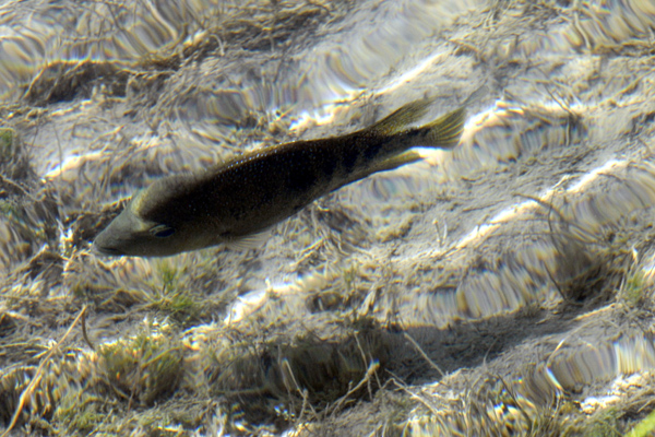
Hendrickson has focused much of his research on the Cuatrociénegas cichlid, a fish that seems to be evolving into two distinct species—one with huge teeth to crack open snails and the other without. It raises questions about the ways new species evolve.
“Can one species living in one place split into two species without geologic separation?” he asks. It’s easy to imagine a species diverging as a result of a separation, he says, such as that caused when South America and Africa split apart millions of years ago, producing two new internally interbreeding groups, one on each continent, but without the ability to interbreed between continents.
“It looks like sympatric speciation, a species splitting into two side by side, is not real common,” he adds. “Yet in Cuatrociénegas, it’s clearly happening.”
Scientists have also been fascinated by communities of microbes that build rocky freshwater reefs called stromatolites. Unlike stunningly vibrant coral reefs, freshwater stromatolites are a bit unremarkable. They’re lumpy and slimy. They range from brown to grey to green. But to the trained eye, they are actually quite extraordinary.
In geological terms, stromatolites are laminated sedimentary structures formed by mats of cyanobacteria and other microbes. Cyanobacteria, or blue-green algae, are thought to have been the first organisms to use photosynthesis to turn sunlight into energy and release oxygen, contributing to the atmosphere that made more complex life possible. The fossil record shows that stromatolites were common from 3.5 to 1 billion years ago. Now, almost non-existent, these living fossils offer a unique window into early life on Earth.
NASA scientists have been keen to study them in hopes of finding “biosignatures” that could be used to reveal alien microbes on other planets. Research in Cuatrociénegas can also have more down to Earth benefits.
Wolaver says Cuatrociénegas is an ideal laboratory to explore ways to make human use of water resources sustainable. World population is expected to reach 9 billion by the year 2050, according to United Nations projections. That’s nearly half again as many people as were alive in 2000.
“We’re going to have to figure out how that many people can live, eat and do all the things they want with water,” said Wolaver. “How does Mexico, which is a mostly arid and semiarid country with increasing populations, grow enough food for its people?” asks Wolaver.
Ten Years On
When asked what the Cuatrociénegas basin will be like 10 years from now, Juan Manuel Rodriguez, a researcher from the Universidad Autónoma de Nuevo León in Monterey who has studied the springs for several years, responds, “It will be finished.”
“It’s not going to be a pretty picture,” adds Hendrickson. “I’m not optimistic about the future of the place with all of the agricultural development that’s going on. Unless that can be completely stopped, I think the chances of recovering the place are pretty dismal. It’ll just continue going downhill very slowly. Hopefully there will be a lot of yelling and screaming as it dries even more.”
He says the balance may have already tipped beyond the point of recovery. With a new sense of urgency, he has shifted much of his energy from basic research to conservation.
Hendrickson and Wolaver say the scientific evidence is clear that large scale irrigated agriculture in adjacent valleys is contributing to the slow drying out of the CCB, but that local, state and federal officials seem to lack the political mechanisms or will to stop the practice and provide truly sustainable solutions for the ecosystem and the human economy it now supports.
Despite the forces arrayed against the springs, there are a few glimmers of hope.
In 2000, The Nature Conservancy teamed up with Pronatura Noreste, a Mexican conservation organization, to buy and manage a 7,000 acre ranch harboring over 130 of the valley’s springs. According to The Nature Conservancy, it is “the first-ever conservation easement in the state of Coahuila and the largest private land conservation purchase in Mexico’s history.” Water from springs on the land flowed via a canal to a nearby ejido or farming cooperative. Pronatura Noreste bought the spring discharge water rights, closed the canal and are using the water to nourish and restore wetlands, another first for Mexico.
In 2006, Hendrickson created the Centro de Investigación Científica de Cuatrociénegas, a permanent research station to facilitate visits by researchers from around the world who want to study the endemic species, stromatolites, archaeology, hydrology and geology of the area. The station helps researchers navigate the paperwork required to work in the protected area and encourages them to share data with scientific peers, conservation managers, policy makers and the public.
In 2007, the Mexican government expanded the natural protected area to 10 times its original size, although it still does not limit the use of groundwater within the protected area.
Hendrickson helped start an eradication program for Arundo, an invasive plant that is spreading across the valley and crowding out native plants.
He’s now reaching out to the University of Texas at Austin community to drum up support for his most ambitious idea yet: to create an interdisciplinary research project that brings together researchers from across the university to intensively study the system and search for solutions. It would include not only scientists, but also policy experts who could help bridge the gap between the science and what farmers, corporations and policy makers actually do.
“The goal would be to change agriculture to preserve a natural ecosystem,” says Hendrickson. “What do we need to do to preserve this? How is agriculture going to have to change and how do we implement policy changes that would result in changes to agriculture that would sustain this natural system?”
by Marc Airhart
For more information about the Jackson School contact J.B. Bird at jbird@jsg.utexas.edu, 512-232-9623.