
Rapid Response Science Missions Assess Potential for Another Major Haiti Earthquake
February 23, 2010
To help assess the potential threat of more large earthquakes in Haiti and nearby areas, scientists at The University of Texas at Austin’s Institute for Geophysics are co-leading three expeditions to the country with colleagues from Purdue University, Lamont-Doherty Earth Observatory, the U.S. Geological Survey and five other institutions.
Rapid response missions can be critical for assessing future risks because a fault can continue to displace the ground for weeks and months after a large earthquake. At the same time, natural weathering processes and human activities can erase valuable geologic evidence.
The goal of the Haiti missions, researchers say, is to understand which segments of the earthquake fault ruptured during the Jan. 12 quake and how much fault movement and uplift of coastal features occurred in locations along or near the fault.
* Expedition 1: Eric Calais of Purdue University led the first expedition, which has ended, collecting Global Positioning System (GPS) data to determine how land moved as a result of the earthquake. A second team participating in the expedition, led by Paul Mann of the Institute for Geophysics and Rich Koehler of the Alaska Division of Geological & Geophysical Surveys, used a helicopter and fieldwork to search for signs of ruptures—cracks at the surface along the main trace of the suspected earthquake fault. They found no signs of surface rupture but evidence for lateral spreading and liquefaction—a phenomenon in which soils behave like a liquid instead of a solid. Earthquakes most likely caused by the same fault and resulting in the same kind of lateral spreading and liquefaction destroyed the Jamaican capital of Kingston in 1692 and 1907. Funding was provided by the Rapid Response Research Program of the National Science Foundation (NSF).
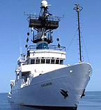
* Expedition 2: The second expedition, beginning Feb. 24, will use a scientific research vessel to examine the underwater effects of the quake. Chief scientist for the expedition is Cecilia McHugh at the City University of New York and Lamont-Doherty Earth Observatory with co-chief scientists Sean Gulick of the Institute for Geophysics and Milene Cormier of the University of Missouri. For two weeks, a team onboard the RV Endeavor will use sonar to map shifted sediments on the seafloor and seismic sensors to examine faults beneath the seafloor. The scientists hope to solve a mystery about how the earthquake unleashed a tsunami that killed seven people and to explain why corals along the coast have now been uplifted above sea level. The 185-foot Endeavor is owned by the NSF and operated by the University of Rhode Island. Funding is provided by the NSF and The University of Texas at Austin’s Jackson School of Geosciences.
* Expedition 3: The third expedition, led by Fred Taylor of the Institute for Geophysics, will focus on large coral heads exposed by coastal uplift during the earthquake. Taylor will use a specialized chainsaw to collect the now dead coral for study of its tree ring-like structure to reveal clues on recent uplift and previous uplifts extending back hundreds of years. He will be assisted by Mann along with Rich Briggs and Carol Prentice of the U.S. Geological Survey (USGS). The Jackson School of Geosciences and USGS are jointly funding the coral study.
The Jackson School places a special emphasis on mounting rapid response missions to the scenes of geo-hazards, supporting previous missions after the earthquake and tsunami in the Solomon Islands (2007) and Hurricane Ike along the Texas Gulf Coast (2008). Few academic organizations have the infrastructure, equipment and expertise to mount a large field expedition on a few weeks’ notice, yet they can yield valuable insights to prepare communities for future hazards.
“We expect a whole raft of studies about the Haiti earthquake coming out based on remote sensing data from satellites and airplanes,” said Sean Gulick of the Institute for Geophysics. “But there’s no substitute for getting on the ground and in the water to look directly at its immediate effects.”
While collecting information that can save lives in the near future is a top priority of the expeditions, the scientists are also working to help cultivate local earthquake expertise. Two Haitian scientists have been invited to participate—Nicole Dieudonne, a representative of the Haitian Bureau of Mines and Energy, and Steeven Smyithe, a student from the State University of Haiti.
“We’re trying to engage the Haitian science community,” said Mann, who will return to Haiti for the second expedition. “They can help us communicate better with Haitian policy makers and people about the geology behind this devastating earthquake and about the risks going forward.”
In 2008, Mann, Calais and colleagues presented a paper at the Caribbean Conference forecasting a 7.2 magnitude earthquake in the area of Haiti, Jamaica and the Dominican Republic. The forecast was based on an integration of geologic information on the Enriquillo-Plantain Garden fault zone with GPS data collected in the region. David Manaker, Calais and colleagues published an article on the same topic in Geophysical Journal International.
MORE INFO:
As a graduate student, Paul Mann identified and named the Enriquillo-Plantain Garden Fault, which ruptured and caused the Jan. 12, 2010 Haiti earthquake. The strike slip fault cuts across the island of Hispaniola (home of the Dominican Republic and Haiti), the Jamaica Passage, and the island of Jamaica.
Mann and Rich Koehler have been working since 2007 on an NSF-funded study of the extension of the fault in eastern Jamaica which could threaten the capital of Kingston, a city of 650,000. Kingston was destroyed by earthquakes in 1692 and 1907 with the likely source being this same fault system. Geologic evidence suggests lateral spreading and liquefaction, as occurred this year in Haiti, also occurred in these earlier quakes. These phenomena are common in areas of intense shaking and have caused the coastline to migrate landward by about 50 meters in local areas.
As part of the second expedition, the scientists hope to solve a mystery about a tsunami that was unleashed by the earthquake, killing seven people.
“The tsunami was a bit of a surprise given the geology of the area and the way the fault ruptured,” said Gulick, one of two co-chief scientists on the expedition. “So we’ll be looking for physical evidence that might support any one of several explanations. We’ll also collect eyewitness accounts from the Jan. 12 earthquake to help guide our understanding of what happened.”
Also participating in the second expedition from the Institute for Geophysics will be Matt Hornbach and Marcy Davis. Hornbach, a research associate, will use a smaller seismic system on board a smaller boat from the RV Endeavor to explore coastal lagoons too shallow for the Endeavor to enter. He will also use computer modeling to help explain the rapid changes in sea level that were observed during the Jan. 12 event. Davis, a marine geophysical technician, will assist in acquiring the Chirp seismic data and processing the bathymetric data collected during the second expedition. Collaborators also include Leonardo Seeber and John Diebold from Lamont-Doherty Earth Observatory, Chris Sorlien from the University of California-Santa Barbara, and Sam de Bow from the University of Rhode Island.
Fred Taylor developed his technique on uplifted corals in the southwestern Pacific during the 1980s. Each species of coral has a specific level with respect to sea level above which it cannot live, which is known as the highest level of survival (HLS). When they are displaced vertically, coral either die back to a certain lower level or start growing higher to compensate. By measuring the change in the shallowest HLS of coral of a given species, Taylor determines how far the seafloor has uplifted or subsided.
Taylor has applied this technique to geologic problems in many parts of the world, including the Solomon Islands, site of a magnitude 8.1 earthquake in 2007. A rapid response mission to the Solomons funded by the Jackson School of Geosciences allowed him to gain fundamental insights into that event. The results were published in the journal Nature Geosciences.
For more information about research at the Jackson School, contact J.B. Bird at jbird@jsg.utexas.edu, 512-232-9623.