
The Big Picture: Rong Fu uses satellite data to study climate processes
December 23, 2008
Climatologist Rong Fu prefers a bird’s eye view of the Earth’s climate. That’s “birds,” as in satellites, which she uses to study climate processes in remote areas such as the Amazon, the Tibetan Plateau, and tropical oceans. This perspective helps Fu understand how climate changes in these remote areas could have an impact closer to home.
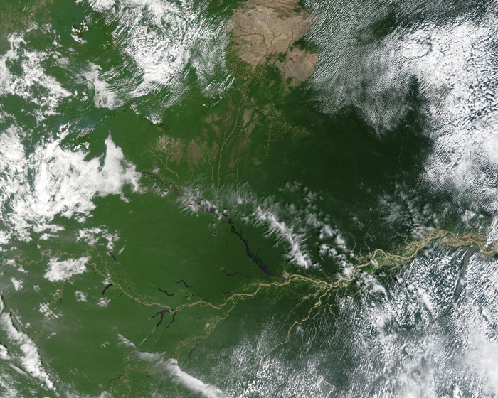
Fu had studied the mechanisms that control the Amazon’s monsoon season, which alternates between the northern and southern regions with one receiving rain while the other is dry. But the trigger that caused the monsoon to switch over was unknown. Fu had speculated that the rain forest itself might be involved through evapotranspiration, the process by which leaves release water vapor. This water vapor, in sufficient quantities, could kick start the thunderstorms that would bring the onset of the monsoon.
Her observations revealed that evapotranspiration did indeed increase toward the end of the dry season, but she could not explain why. Satellite data provided the answer: Leaf coverage in the Amazon actually peaks near the end of the dry season, thus increasing evapotranspiration. While perhaps counterintuitive, it turns out that sunlight, not precipitation, is the limiting factor for leaf production.
“It’s some of the first evidence that the rain forest plays an active role in rainfall climatology,” Fu said. “If you lose rainforest you are likely to have a longer dry season and a drier climate over the Amazon. When I started more than 10 years ago, there was very little observational work to try to understand the mutual dependence between rainforest and climate. There were models, but their results needed to be supported by observational data. Through my observational work, at least now we have a mechanism in place.”
Burning Questions
Fu has also investigated the impact of biomass burning on the Amazon’s monsoon season; her results point to a weakening or delaying of the transition from dry to wet season. Climate models predict that deforestation and biomass burning will result in a drier Amazon, and Fu’s observations seem to lend support to that conclusion.
Together, these observations may spell trouble for the future. Fu is concerned that the rapid clearing of the rainforest for such things as cattle, coffee, soy beans, and biofuels, combined with possible intensified droughts, could cause rainforest loss on a large scale. The carbon stored in the rainforest would then be released into the atmosphere, further increasing atmospheric carbon dioxide (CO2) by an amount comparable to that emitted by a decade of global fossil fuel use. Should this occur, it would greatly complicate efforts to keep atmospheric CO2 below levels considered dangerous for global climate. What’s more, flow changes in the Amazon River could also affect hurricane intensity as storms move across the Caribbean Sea.
Rising atmospheric carbon dioxide levels have drawn the public’s attention in recent years but, of course, there’s more to the climate change story than just CO2. Water vapor also plays a significant role, and Fu has been investigating how water vapor is transported to the troposphere and stratosphere.
“If you warm the climate, you will evaporate more water vapor into the atmosphere,” Fu said. “Water vapor is a strong greenhouse gas which will in turn amplify the warming. It is a positive feedback that amplifies the original warming, and this is a destabilizing factor.”
There is evidence that water vapor played a role in the distant past when Earth’s climate was significantly warmer, and so it may again in the future. A better understanding of how water vapor influences climate will help researchers refine current climate models.
“If you double CO2 concentration, you get approximately 1 to 1.5 degrees of warming,” Fu said. “But if you increase the water vapor associated with this, you get another degree or degree and a half. It is really the single biggest positive feedback.”
Stratospheric Heights
Fu has used data from the Upper Atmosphere Research Satellite and its successors, NASA’s Aura and Aqua satellites, which are part of the Earth Observing System (sometimes called the “A-Train”), as well as other satellites. Like most scientists, she is happy with good data wherever she finds it.
“The main advantage of the A-Train is that the measurements are closely synchronized,” Fu said. “These satellites take a variety of different measurements so you can see the depths of these systems, how much ice is being injected, and how much water vapor and carbon monoxide is being pumped into the stratosphere.”
While at the Georgia Institute of Technology’s School of Earth and Atmospheric Sciences, Fu led a group that combined data from Aqua and Aura to study how water vapor reaches the stratosphere. Previous research had focused on water vapor entering from the tropics, but Fu’s team discovered that thunderstorms over the Tibetan Plateau, with its high elevation, are one of the primary pathways for water vapor to reach the stratosphere. This same pathway, it turns out, can also transport air pollutants efficiently into the stratosphere, where they can rapidly spread around the globe.
Land & Sea
One of Fu’s current projects is investigating the role that land surface processes and large-scale atmospheric circulation play in determining the transition to a warm season precipitation regime and summer drought in the Southeastern United States. She is examining the role played by the Bermuda High, a persistent zone of high pressure over the Atlantic, which can influence rainfall patterns in the United States. When this zone moves westward, the Southeast comes under its sway and experiences reduced rainfall as moisture is transported along its edge.
“The empirical link is definitely there—you can very clearly see that from the data,” Fu said. “But we don’t really understand the physical mechanisms behind it. To study this, long-term meteorological data is very important to get the large-scale picture.”
The current understanding of what might control year to year or decade to decade variation of climate for the United States centers on ocean surface temperature anomalies, such as the El Niño Southern Oscillation or the Atlantic sea surface temperature decadal variations.
“People find that simply using this information cannot explain the drought,” Fu said. “Maybe the land surface and the soil moisture memory, which results in surface flux that can either amplify or dampen the variation forced by the ocean, becomes a more important factor. This is an area where we don’t have decent data.”
Calculating soil moisture by using rainfall and temperature data from the last 50 years in the land surface model, and then combining that with available satellite data, is one approach – but Fu recognizes its limitations.
“The good thing is now you actually have something that is physically reasonable because it’s based on the model,” Fu said. “But I am an observation person, so I’m usually more skeptical of the models.”
That is something that Fu would like to work on at the Jackson School. She hopes to use her observations in collaboration with other scientists to help refine current climate models.
For more information about the Jackson School contact J.B. Bird at jbird@jsg.utexas.edu, 512-232-9623.