
Warped: The History of a Curious Plate Boundary
October 1, 2008

When tectonic plates meet on the seafloor, they tend to do one of three things: slink away from each other (spreading), crawl past each other (transform motion), or smash headfirst into each other forcing one to the bottom of the dogpile (subduction).
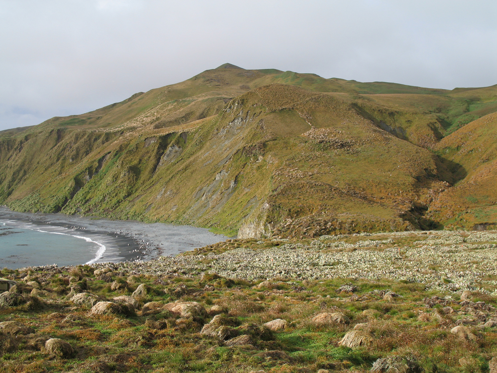
And then there is Macquarie Ridge, which lies south of New Zealand where the Australia and Pacific Plates meet. Here the plates are more like two tireless and entwined sumo wrestlers shifting a hold from here to there, transferring weight from one foot to another, pivoting to exploit any weakness. Over the past 40 million years, the plate boundary has shifted from spreading to transform motion, and now in some spots, to subduction. It’s the only place in the world where such a three step transition is clearly recorded in the geologic record.
Geologists from the University of Texas at Austin’s Jackson School of Geosciences first went to Macquarie Ridge in the mid 1990s on the Australian research vessel Rig Seismic to collect marine geophysical data that might make it possible to reconstruct the plate boundary’s tortured history.
Some intriguing details began to emerge. The original spreading ridge hadn’t stayed put over time, rather segments migrated across the seafloor while becoming shorter and at the same time rotated about 90 degrees. That was consistent with other studies that had shown that relative motion between the two plates had changed over time. It also made this ridge unique because it was one of the only spots on Earth that record signs of such a high degree of rotation. Most other spreading ridges that rotate max out at 20 or 30 degrees.
Perhaps most perplexing was the fact that the spreading ridge segments shrank.
“How does the ridge become shorter?” wondered co-investigator Christina Massell Symons. “It can’t just disappear into a black hole. If it becomes shorter, something else must be taking its place or growing at it’s expense.”
The researchers also struggled to explain why magmatism—the upwelling of molten rock into the gap created by the spreading plates—apparently shut off at some point in its history.
Sorting out the history of Macquarie Ridge is more than an academic exercise. It could have applications to real world problems.
“Ultimately, we’d like to be able to predict earthquakes and volcanoes,” said Sharon Mosher co-investigator and chair of the Jackson School’s Department of Geological Sciences. “To do that, we have to understand how crust deforms along plate boundaries.”
On December 26, 2004, the Great Sumatra-Andaman earthquake struck with an estimated magnitude of at least 9.1 and spawned tsunamis across the Indian Ocean that killed more than 225,000 people. Just three days earlier another great earthquake, with a magnitude of 8.1, struck Macquarie Ridge.
“But there was no tsunami because the plates were moving laterally past each other,” said Mosher. Tsunamis occur when seafloor rapidly moves up or down, setting large volumes of water in motion. “As the plate boundary evolves to more and more subduction with time we will get earthquakes with large vertical motion at Macquarie Ridge and with the potential for tsunamis.”
The team’s results might shed light on earthquake and tsunami risks at other plate boundaries.
Rock, Paper, Scissors
The researchers collected a wealth of data with marine geophysical instruments including multibeam sidescan sonar to map the bathymetry of the seafloor, a seismic array to measure the thickness of sediments, and a magnetometer to record magnetic field reversals that indicate the age of formation of new crust at a spreading ridge and its orientation at the time of spreading.
But all the data in the world is worthless unless you know how to interpret it.
Mosher worked with her colleagues on the problem for years, but struggled to tease the tectonic history of the region from the data. She became so frustrated that one day she took a stack of colored construction paper and began to cut it in two along an imaginary spreading zone. She pulled the pieces apart a little, rotated them slightly and then taped them to the sheet below. Then she cut the second sheet and repeated the process. Then the third sheet, then the fourth, and so on, mimicking the continuous creation of seafloor at a spreading ridge as the orientation of the ridge itself changes.
The first series of manipulations didn’t match the patterns suggested by the data. So she made more construction paper models, varying her approach each time by, for example, changing the rate of rotation and the length of the spreading ridge segments.
“And then I suddenly realized what could happen and what couldn’t happen,” said Mosher. “We actually fundamentally changed our ideas after I did those paper models,” she said.
As she worked her way down through the stack of paper, earlier steps would be destroyed, so she stopped every few steps to scan the cutouts onto her computer.
“My grad students thought this was pretty hysterical,” said Mosher. “But they’re pretty impressive when you see them.” Her colleagues asked why she didn’t just do it all on the computer.
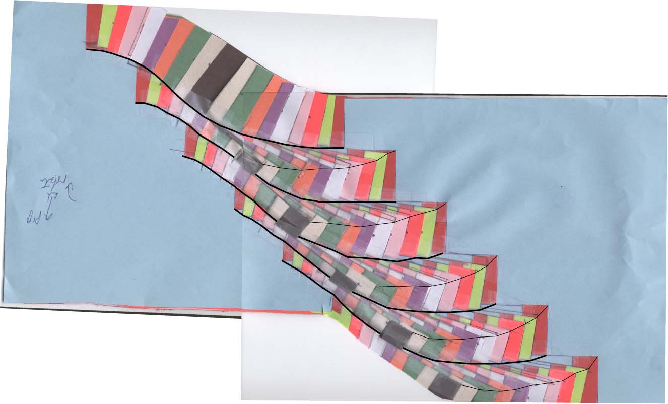
“You can’t do them on the computer until you understand what you’re doing,” she said. “Yes, if I were a really good computational geoscientist maybe I could have done the whole thing that way, but I would be really surprised because there’s an incredible amount of intuitive understanding in the whole process.”
“It goes to show that geology is hands-on, visual science,” said Massell Symons, who began working on the project as Mosher’s master’s student and now works for Scripps Institution of Oceanography. “We needed a visual way to capture what was happening through time.”
Twisted Logic
In an article published last February in the journal Geology, the researchers proposed a mechanism to explain the changes at Macquarie Ridge.
“In our case, it was by taking a plate boundary broken into multiple spreading ridge segments, rotating the segments, destroying some of them and ultimately converting the plate boundary into transform motion,” said Massell Symons. “That’s the simplest way to explain it.”
“When those spreading ridges were changing in orientation with time, individual segments migrated through the seafloor, shortening, sometimes completely disappearing, and transferring crust from one plate to another,” said Mosher.
The critical insight was that as the ridge segments migrated and twisted into new orientations, one end of the ridge propagated through existing seafloor while the other end failed, and the end that failed did so faster than the end that propagated. Like two crabs scuttling across the seafloor in the same direction, the pursuer faster than the quarry, the gap between the two ends narrowed.
It was a combination of rigorously interpreted geophysical data and good old fashioned paper and scissors that made the insight possible.
“We’ve presented what we think to be the best explanation of the process of this change in spreading ridge orientation and hence, spreading direction,” said Massell Symons. “Our model fits the data well in a geometric sense.”
The researchers plan to publish a second paper highlighting the data analysis that supports their proposed mechanism and a third that, for the first time, explains why magmatism ceased at Macquarie Ridge about 6 million years ago.