
Going with the Flow: David Mohrig studies the changing face of our planet
December 1, 2006
David Mohrig keeps a flat, palm-sized rock on his desk that he’s had since he was six years old. He found it on a fossil-hunting trip with his father. Look closely at the piece of shallow marine limestone and you’ll see broken bits of ancient denizens of the sea: bryozoans, brachiopods, crinoids, gastropods and trilobites.
“I was kind of hooked just hunting for fossils and exploring the streams and hill slopes,” said Mohrig, who grew up in southern Minnesota. “My interest in geology started early and it stayed.” Even as a child, he was curious about how sand was moving through the river in his hometown.
Mohrig joined the University of Texas at Austin’s Department of Geological Sciences as an associate professor of geology this past summer. Before coming to the university, he was an associate professor of geology at the Massachusetts Institute of Technology.
He is interested in how Earth’s surface evolves over time and how it is affected by changes in the environment such as sea level, precipitation and tectonics. He has studied how sediment dunes change shape as they move along a riverbed; compared land-based and underwater channel flows; pondered why underwater landslides travel as far as they do; and tried to understand what channels on Mars reveal about ancient climate on the red planet.
Mississippi Delta
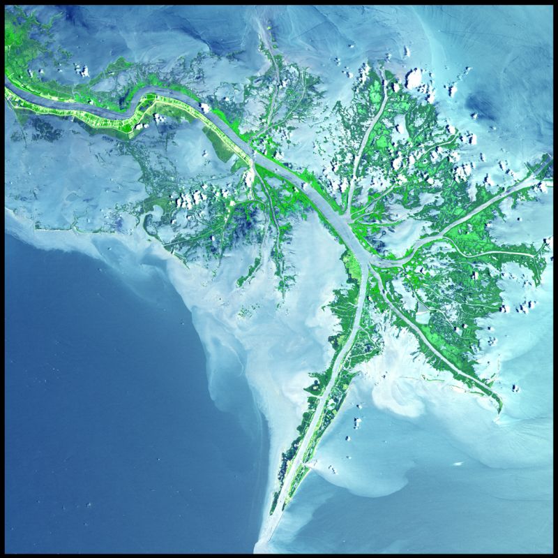
One fertile stream of research for Mohrig is the Mississippi Delta. A combination of human impacts and natural forces is wiping 25 square miles of delta wetlands off the map each year. That impacts coastal fisheries and reduces natural defenses against storm surges such as those caused by Hurricane Katrina. So there is considerable interest in delta restoration.
Before the land can be restored, Mohrig cautioned, it’s important to understand how the delta was formed and how it worked before humans altered it.
“We’re looking at a specific image of the surface,” he said. “But we don’t know if it is a representative image.” The delta may have had a number of different states over the last several million years. “If the delta today is not a standard looking surface, it would be helpful to know that now before we start trying to restore it,” he said.
For example, according to Mohrig, there is a debate right now about the rate at which the delta is subsiding, or sinking. How that rate might have changed over time remains unclear. “That’s a basic question and it affects everything we do,” he said.
Collaborations with industry may provide answers. The energy industry collects seismic data in the Gulf of Mexico to explore for new resources. This data can be used to create three-dimensional maps of now buried delta surfaces. Mohrig can use these to determine how the delta has evolved over time. He already uses some data from WesternGeco and hopes to get access to more.
“We could collect this data ourselves,” he said. “But it is expensive to collect and it makes sense to work with industry and not recollect data that already exists.”
The work is part of a larger initiative at the National Center for Earth-surface Dynamics (NCED), a National Science Foundation Science and Technology Center where Mohrig is a principal investigator. NCED participants, who include ecologists, engineers, geologists and mathematicians, study how human land use shapes Earth’s surface and how the changing surface in turn affects all life on the planet.
Channel Surfing
Mohrig often does laboratory experiments using flumes to compare how materials flow on dry land versus underwater. He was surprised to find that the way material flows through channels is different in these two environments, even though surface features produced by terrestrial and submarine flows often look similar.
On land, once a current of water and sediment gets deeper than the confining channel topography—say, after a hard rain—it just spreads out and floods nearby land. But underwater, because the flowing material is only slightly more dense than the surrounding water, the currents can be a number of times thicker than the channel that confines them.
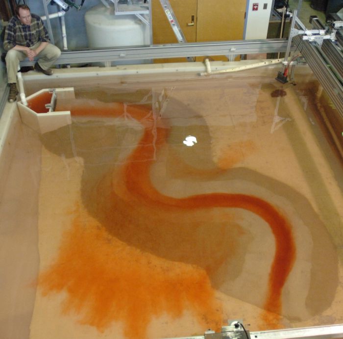
“They’ll still be guided by that channel, which goes against our intuition,” Mohrig said. “You would think it would just spread laterally under its own weight with little regard for the relatively subtle bottom topography. But there is a basal, high density core that can be confined in these channels and the upper flow is guided by that and dragged along.”
Numerical models of the system did not predict this phenomenon. That’s because the underlying physics is often so complex that the models, to remain manageable, leave out some terms. “There are many occasions where we throw out a wrong term assuming it won’t be important,” Mohrig said. “The lab experiments tell us what terms we really shouldn’t throw out.”
Underwater Landslides
As a post-doctoral associate in the mid-’90s at the University of Minnesota, Minneapolis, Mohrig helped solve a mystery about underwater landslides.
There is evidence in the geologic record that underwater landslides often run much farther across the seafloor than similar landslides on dry land. This was enigmatic because researchers knew two effects dampened underwater landslides: 1) water resists motion more than air does, and 2) the buoyancy of rocks and sediments underwater makes them effectively lighter than they would be in air.
Mohrig and his team set up an experiment in the lab that mimicked an underwater landslide. They spent a year designing and building what they called “the fish tank,” a tank 10 meters long, three meters high and one meter wide with a channel down the middle. When they opened a gate on one end, a mixture of sediment and water rushed along the channel. The researchers performed the experiment with the tank in open air and then again full of water. High speed video cameras allowed them to slow time down and carefully observe the landslides.
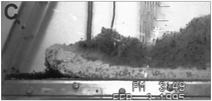
In the underwater case, Mohrig observed water flowing under the leading edge or “head” of the landslides and lifting them up. In the real world, this basal lubrication reduces friction allowing a landslide to skate across the seafloor much farther than it would otherwise. “It turned out that underwater, these slides and avalanches would hydroplane like your car tires,” said Mohrig.
The research appeared in 1998 in the Geological Society of America Bulletin, but Mohrig’s interest in landslides was more than academic.
“Submarine landslides are a great hazard,” said Mohrig. “They can trigger tsunamis and damage deep ocean infrastructure such as communications cables and pipelines we use to get hydrocarbons onshore.” Underwater avalanches can also bury seafloor life.
In the late 1990s Mohrig took a break from academia for several years and worked as a senior research geologist for Exxon in Houston. As part of the company’s efforts to improve offshore drilling technology, he developed methods for applying sediment transport mechanics to seismic maps Exxon had made of sedimentary deposits. “I gave them quantitative methods for determining how the reservoirs were plumbed so they could more efficiently extract hydrocarbons,” he said.
Out of this World
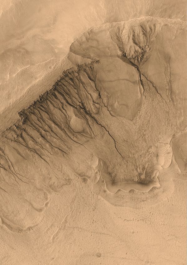
Mohrig’s work is not limited to Earth’s surface. On Mars, there are large fan-shaped deposits with channels cutting across them. Some scientists point to the channels as proof that Mars was once a much warmer and wetter planet than it is today and that its surface might have been able to support life.
Members of Mohrig’s research group realized that they could take their understanding of how fluids and sediments move on Earth and apply it to satellite and rover images of Mars. They determined that the channels could have been caused by asteroids or comets hitting Mars, temporarily heating up and releasing water frozen near the surface. In other words, the channels shouldn’t be taken as proof that Mars was ever wet and warm enough—long enough—for life to get a toe hold.
Even as his research portfolio expands to Mars, Mohrig remains well grounded.
“I still have the rock hammer I got for my seventh birthday,” he said. “It’s been a hassle sometimes. There were several times when I left it behind somewhere and I’d have to go back and get it. I’d think, ‘I don’t want to go back up that mountain.’ But I still have it.”
by Marc Airhart
Sidebar: Vanishing Wetlands
The Mississippi Delta is built up from sediment carried across the continent and deposited in the Gulf of Mexico by the Mississippi River. The river discharges on average about a half million cubic feet of water and sediment per second, the sixth largest discharge worldwide.
The Mississippi River is restless. In just the last 7,000 years, it has shifted along the coast at least four times, each time emptying into the Gulf at a new spot. The abandoned outlets compact under their own weight and sink without the influx of sediment from the river. Mohrig says left alone, the river’s main discharge to the Gulf would shift westward to one of its tributaries, the Atchafalaya River.
In the past century, humans have brought the Mississippi to heel, damming it, redirecting its course and hemming it in with 2,000 kilometers of levees and dikes. As a result, a greater fraction of the sediment carried by the river is now discharged out in the deep ocean, rather than building up wetlands. Add to that the draining of wetlands for development and agriculture and the dredging of canals for hydrocarbon exploration and commercial and recreational boat traffic, and the human impacts on these wetlands has been devastating.
The problems do not end there. As Earth’s oceans warm, sea level rises. The effect is compounded in the delta by subsidence, a natural compacting and sinking of the land. About 25 square miles of wetlands around the Mississippi Delta disappear each year.
The decline in wetlands could have big impacts on the fishing industry, the transportation industry and the survival of migrating waterfowl. It also reduces natural defenses against storm surges such as those caused by Hurricane Katrina.