
Groundwater Availability Faces Big West-East Divide That is Expected to Intensify
June 5, 2026
Groundwater is a critical resource — but one that can be easily and sometimes irreversibly exhausted.
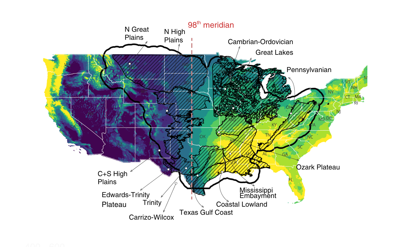
In a study published in the journal Earth’s Future, Jackson School of Geosciences researchers take a long view of groundwater availability in the Mississippi River Basin, the country’s largest river basin, and adjacent Texas aquifers. They trace the gain and loss in groundwater levels in 12 aquifers from 1950 to the modern day, and make projections about their future levels.
“We included Texas, because the same questions of management and the questions of climate about the Mississippi also apply to Texas aquifers,” said the study’s lead author Ashraf Rateb, a research assistant professor at the Jackson School’s Bureau of Economic Geology.
The research highlighted the large divide in water availability that exists between the western and eastern portions of the country. The 98th meridian serves as the dividing line for this transition, with the longitudinal map line running through the Great Plains and San Antonio.
The western side of the line has a dry climate. This has led to communities tapping groundwater for irrigation and drinking water, but facing difficulty in restoring the water that’s been pumped out. Even with pumping regulation, there is little recharge of the High Plains or Ogallala Aquifer to replenish the groundwater that’s been withdrawn.
In contrast, the eastern side is wet and humid. Although aquifers in this region faced water-level declines in the pre-regulation era of 1950-1975, these declines have largely stabilized or even reversed. With surface water available, communities have the option to diversify their water supply so aquifers can recharge and recover.
The Texas Gulf Coast aquifer, which runs along the coastal edge of the state, is a success story of aquifer management highlighted in the paper. After facing a 15-meter decline in water level in the pre-regulation era, the aquifer has since almost completely recovered, with gains happening rapidly once regulations were put in place in 1970s.
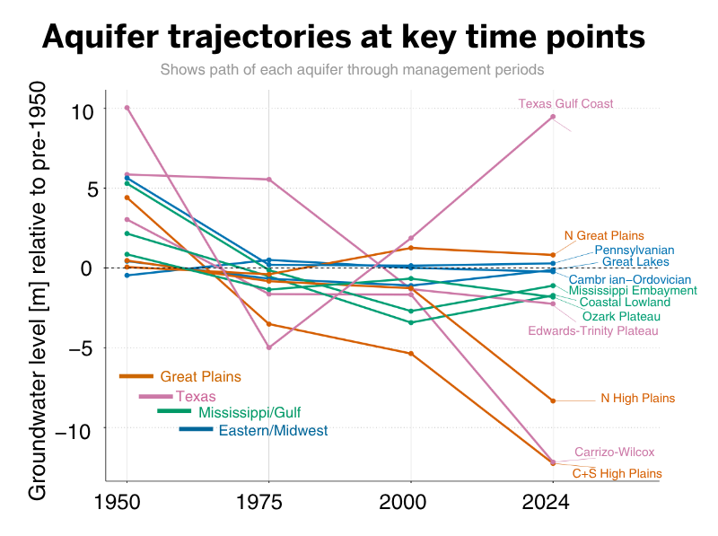
The climate dichotomy the researchers highlight in the paper is expected to only intensify in the coming decades, according to climate models. Models forecast wetter winters and springs in both the west and the east. However, the potentially hotter summers expected in the west could dry up soil moisture. And some western aquifers could face critical levels by 2050 that would put them at risk of functional exhaustion if current extraction trends don’t change.
Co-author Bridget Scanlon, a research professor at the bureau, said that there are many uncertainties that go into tracking and predicting water levels in groundwater at the local level — particularly when working with decades-old and spotty well-data, coarse satellite readings, and extrapolating from recent water-use trends. However, the research is clear about different climate regimes in the west and east, and that they are on track to intensify going forward.
“A big thing that we try to do is put things in context: regional context, time context, long-term, how it has evolved, how the current system is relative to the long term, so that it might help us see where it might be going,” Scanlon said.
The research was funded by the National Science Foundation.
For more information, contact: Anton Caputo, Jackson School of Geosciences, 210-602-2085; Monica Kortsha, Jackson School of Geosciences, 512-471-2241.