
Seismology of Haiti Earthquake
January 13, 2010
(last update: Feb. 23)
Full list of online and downloadable resources.
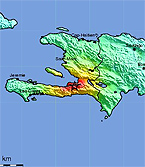
According to the U.S. Geological Survey, a magnitude 7.0 earthquake struck near Haiti’s capital city of Port-au-Prince at 4:53 p.m. local time on Tuesday, January 12, 2010.
Paul Mann has received many requests from the media for information about the seismology of Haiti. Mann is a senior research scientist at the Institute for Geophysics in the University of Texas at Austin’s Jackson School of Geosciences. He and several colleagues have conducted research in the Caribbean for many years. In 2008, he and colleagues at other universities and agencies forecast that due to accumulated strains along a boundary between tectonic plates, a region including Haiti, Jamaica and the Dominican Republic was due for an earthquake on the order of magnitude 7.2 (see three links to the right).
Following are some notes from Dr. Mann:
To all: here are some reprints that show the location of the Enriquillo-Plantain Garden fault zone and the setting of the Haiti earthquake. Feel free to use and distribute them to interested groups including news media.
Here are some answers to questions that have come up from various people:
This fault forms a boundary between the Gonave microplate which includes much of the land area of Haiti and the Caribbean plate to the south.
The fault is similar in structure and character to the San Andreas fault of California: ie, both are strike-slip in nature with the plates moving past each other in a horizontal direction. However, the EPGFZ and San Andreas fault systems are part of different plate boundaries and therefore not directly linked.
The Gonave microplate is wedged between the much larger North America plate and the Caribbean plate. This means that there are two parallel zones of strike-slip faults in this part of the Caribbean (cf map below); the northern zone called the Septentrional-Oriente fault extends along the northern coast of Haiti to the southern Cuba and along the Cayman trough to Central America. The Enriquillo is the southern zone extending from Hispaniola to Jamaica. The two zones merge near the Mid-Cayman spreading center.

The epicenter in Haiti as reported by the USGS is very close to the fault (about 3 km); the preliminary focal mechanism is consistent with the geology of the fault (left-lateral strike-slip and active based on its surface features and associated structures). Note that the EW plane on the focal mechanism is the likely fault plane as the fault also strikes EW.
Link to USGS epicenter location and focal mechanism:
http://neic.usgs.gov/neis/FM/neic_rja6_wmt.html
The GPS papers attached show the plate motions determined along with discussion of the deficit accumulated along the fault since the last large earthquakes that we suspect were generated by the fault in the 18th century. The slip deficit of about 2 meters based on the assumption that the fault was last active in the 18th century is consistent with an earthquake of this size.
The last large earthquake based on historical records in the Port-au-Prince area was in 1770.
Long quiescences of earthquakes along strike-slip faults that can last hundreds of years are common as these types of faults are locked at shallow crustal levels (< 20 km) and slowly accumulate strain that leads up large earthquakes of this type.
The USGS indicates that the depth of rupture was about 10 km; this is also consistent with its strike-slip nature.
Earthquakes are more common in the eastern part of Hispaniola where fault motions include both thrusting and subduction.
There has been no previous fault trenching along this segment of the EPGFZ so we do not know the history or repeat time of earthquakes along the fault.
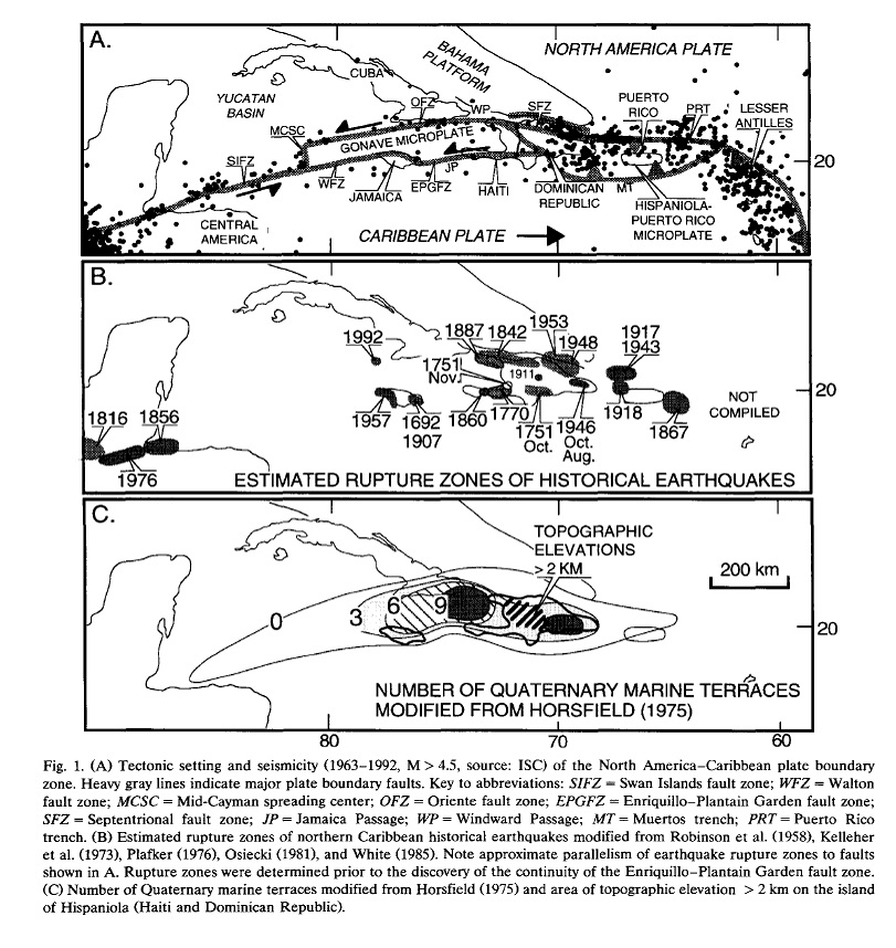
The Enriquillo-Plantain Garden fault extends from the island of Hispaniola to the island of Jamaica and to the west of Jamaica. The fault has been recognized for many years along with its hazard to cities along it.
The chances of tsunami with this event are very small since the fault extends down the length of the southern peninsula of Haiti and does not go offshore until it reaches the western tip of the peninsula. For this reason, the ruptured part of the fault affected only land areas.
A more pronounced hazard of this event would be landsliding since many residences are built on the steep mountain slopes that form the southern of Port-au-Prince and the city of Petionville.
Contacts of geologists in Port-au-Prince: best person to ask would be Eric Calais who operates a GPS network in Haiti.
Hope this helps, Paul Mann.
Here are answers to more questions from reporters:
Q. I understand that you warned that such an earthquake might hit the region recently. Does the magnitude and position of this earthquake fit with what you would have expected? With what kind of frequency would you expect to see this magnitude of earthquake in this region?
Warning: based on merging geologic information about a major strike-slip fault (Enriquillo-Plantain Garden fault known since early 80s with more recent GPS data collected by Eric Calais at Purdue Univ). Fault zone is associated with a band of large eqs back to 18th century including large events that have affected the island of Jamaica.
Magnitude and position of earthquake; GPS data showed slip deficit based on the assumption that the fault had not been active since a large eq affected the area in the 18th century. Slip deficit of about 2 m would equal M7.2 eq.
Frequency of events: nothing known on this since no fault trenching of this fault system in Haiti. Fault trenching provides historys back 100s to 1000s of yrs. See Prentice papers on northern strike-slip system which illustrate this method and show large hazard on this fault (eq as large as 7.5 expected based on slip deficit along it).
Q. Would better buildings have saved lives?
Better bldgs would definitely have saved lives. Problem in areas with infrequent but large eqs like Haiti: complacence sets in since frequency of large and destructive eqs might extend longer than many generations of people.
Q. Should more stringent building regulations have been in place?
Building codes in Haiti: I am not familiar with this. You might address this question to Ellen Rathje at UT: e.rathje@mail.utexas.edu
Q. Can any of the neighbouring places/islands learn any lessons from this quake?
Lessons to learned: these faults are dangerous esp when large population ctrs like PaP, Kingston, Jamaica, or Santiago, Dom Rep or so close to the faults. People must be educated for the dangers even thought they might have never experienced a large shock in their lifetime.
Q. Are there lots of regions of the world that might expect mag 7 earthquakes every few centuries?
Other areas: basically any plate boundary in areas of dense population.
Q. If so, how should these regions prepare/cope with that risk? Should they have better building regs and education?
Preparation: three parts of a triangle: geologic research on faults (mapping, trenching, GPS, modeling), engineering safer bldgs, and outreach and educating the public.
Q: Would you consider that you and coworkers have predicted the Haiti earthquake as stated in several newspaper and internet articles about your work?
Earthquake prediction to a seismologist means that the epicentral location, date and size of the event can be determined before the earthquake occurs on faults that may have been quiescent for years or even centuries. In our Haiti studies, we estimated the size of the future event (M7.2) based on the time we inferred since the fault was last active (historical earthquake event in 1751 that we assumed was the last earthquake on the segment of the fault in the part of Haiti near Port-au-Prince), the rate of slip along the fault as determined from GPS measurements in Haiti published by Manaker et al. (2008) (7 mm/yr), and the location of the rupture (the Enriquillo-Plantain Garden fault zone (EPGFZ), a strike-slip fault we have studied from geologic mapping).
All attempts to precisely predict the exact date of a major earthquakes on the many plate boundaries and seismically active intraplate areas on the planet have ended in failure. Attempt to forecast the likely sites of future earthquakes based on GPS studies and fault mapping have been more successful since they are less specific (ie, no certain date or epicentral locations).
The calculation that is the basis for our forecast for a strong earthquake in the southern Haiti area is simple: GPS shows 7 mmn/yr on EPGFZ, historical records show last earthquake in Port-au-Prince area 250 yrs ago, so 7 mm X 250 yrs = 1.7 m of accumulated strain that is known from previous earthquakes with this amount of measured displacement along with theoretical analysis to yield about a magnitude 7 earthquake.
The potential human impact (or seismic hazard) of the earthquake is based on the existence of a large population center (Port-au-Prince, city of 2 million people) within 20 km of the trace of the EPGFZ determined by mapping (Mann et al., 1995). Proximity of people means that they receive the full force of the energy suddenly released by the strike-slip fault at shallow depths. Poor construction esp on steep slopes as in the PaP area accentuates damage and consequently casualties. Construction of unconsolidated soils esp near the waterfront area and along river valleys draining the adjacent mountain range (and now largely built over) may have also contributed to shaking and building damage.
Our talk presented at the Caribbean Conference in 2008 warning of the potential seismic hazard posed by the EPGFZ in light of the new GPS results (Mann et al., 2008) was targeted at both geologists and policy makers in the densely populated Port-au-Prince area.
Since we could not determine the exact date of the future rupture based on the available information, our work was not an earthquake “prediction”. A better term to describe the study would be “forecasting”, similar to the way this term is used by meterologists, who “forecast” future weather trends but cannot “predict” exact weather conditions on specific dates weeks or months into the future.
A second forecast done by our group involves the Septentrional fault zone of the northern Dominican Republic (cf. papers by Prentice et al). This second, northern strand of the Carib-Noam plate boundary has a faster rate than the EPGFZ and therefore accumulates strain at a faster rate. Our trenching on the SFZ in the Cibao Valley, Dom Rep, has shown it as remained quiescent for 800 yrs thus yielding a much larger forecasted earthquake of M7.5. As in the case of the EPGFZ, we have no idea when this fault might rupture: tomorrow or 100 yrs from now? However, the Haiti event shows the importance of eq research, retrofitting older buildings and public education in the area of the SFZ (Cibao Valley, Dom Rep) to avoid a repetition of the Haiti disaster along that part of the plate boundary.
Hope this helps! Paul.
Also See:
News Release: Rapid response missions assess potential for another major Haiti earthquake (Feb. 23, 2010)
Interseismic Plate coupling and strain partitioning in the Northeastern Caribbean (2008) (PDF)
Summary of Presentation at 18th Caribbean Geological Conference (2008)
Presentation Delivered at 18th Caribbean Geological Conference (2008) (138MB PPT)
Full list of online and downloadable resources.
For more information about research at the Jackson School, contact J.B. Bird at jbird@jsg.utexas.edu, 512-232-9623.