
Zama Basin’s Superb Sand the Result of a Drive-By Microcontinent
April 2, 2025
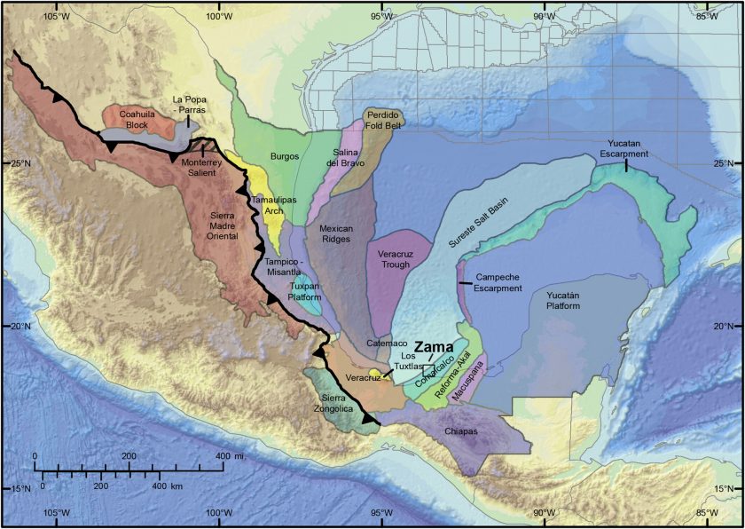
The high-quality sands that make up the oil reservoirs in the Zama Basin in the Gulf of Mexico really shouldn’t be there.
Large sandstone deposits such as Zama’s don’t exist without large rivers carrying a huge load of sediments from the highlands into the sea. But anyone looking over the long history of this basin would note that there are no rivers mighty enough to do the job. Furthermore, most of modern Mexico is dominated by volcanic deposits that tend to deteriorate reservoir quality. Not only do these sands not belong here, they’re much cleaner than expected.
Research shows that, surprisingly, an errant piece of a continental fragment that makes up modern day Central America explains how these sands made their way to the Gulf, playing a key role in making Zama Basin the prospective deepwater oil field that it is today.
In a two–part study on the geologic formation of the Zama Basin and its oil reservoirs, two researchers from The University of Texas at Austin’s Jackson School of Geosciences analyzed samples from exploratory well cores to uncover the mysterious origin of these sands.
Their research was published in the journal Basin Research.
John Snedden, a research professor at the University of Texas Institute for Geophysics, and Daniel Stockli, a professor and the chair of the Department of Earth and Planetary Sciences, got permission by Talos, the oil company that found Zama — a 600-1,000 million barrels of oil equivalent discovery — to take these samples in 2020 at the onset of the COVID-19 pandemic. Students were not allowed on campus at the time, so Stockli cleaned these samples in his home garage, and then spent 10 days alone in the UTChron Lab separating and analyzing tiny, durable minerals called zircons from the other sediments in the samples — a task typically completed by undergraduate students.
Zircons act as geologic fingerprints that can pinpoint exactly when and where sediments originated. And these zircons’ home was not in Mexico, Stockli discovered.
Ten million years ago, a chunk of a granitic continent traveled along the west coast of what is modern day Chiapas, Mexico, tacking itself onto the mainland. A small river — the 10-million-year-old equivalent of the modern day Grijalva River — that wound through the area suddenly had a much larger drainage basin to supply sediments before heading to the sea. In effect, the river became temporarily longer and the catchment area became larger, which means the flowing river’s waters were picking up more sediments, and a much bigger pile of sand was being delivered into the gulf. When the microcontinent continued on its journey, the river was cut off at its head and collapsed back down to its original size.
Stockli’s findings add to the body of research supporting the theory that this microcontinent in fact traveled down Mexico’s western coast before landing where it is today, making up Honduras and Nicaragua.
“It was a drive-by sand shoot,” Stockli said.
These sands entered the Zama Basin in a very short timeframe, geologically — 1 million years, Snedden said.
“That’s remarkable. That’s an incredibly fast sedimentation rate, and that’s incredibly fast to go from the source terrain to the basin way out there in deepwater Mexico,” he said.
Snedden led part two of the research, which reconstructed the route these sands traveled from the shoreline to the undersea basin. He built upon Stockli’s research, working with seismic and well data from in and around the Zama Basin, with help from consulting geologist Mark Rowan, to map the pathway the sands traveled along the rugose Miocene seafloor.
Knowing more about the porosity, permeability, and where the sands came from — in this case from the southeast — now allows oil and gas companies to place wells seeking similar sands in more advantageous positions.
“Our work is helpful in a complex system like this,” Snedden said.
This research was funded by Talos Energy, which is a partial owner of the Zama Basin. Talos is a member of the Gulf of Mexico Basin Depositional Synthesis Project consortium — an industry associate program at UTIG that was previously directed by Snedden. Talos financially contributes to the Gulf Basin Depositional Synthesis consortium, which supports the research and salaries of the scientists and students who work there. The University of Texas at Austin is committed to transparency and disclosure of all potential conflicts of interest. All UT scientists involved with this research have filed their required financial disclosure forms with the university.
For more information, contact: Anton Caputo, Jackson School of Geosciences, 210-602-2085; Monica Kortsha, Jackson School of Geosciences, 512-471-2241; Julia Sames, Department of Earth and Planetary Sciences, 210-415-9556.