

A Better Way to Forecast Floods
Q&A with Professor Zong-Liang Yang
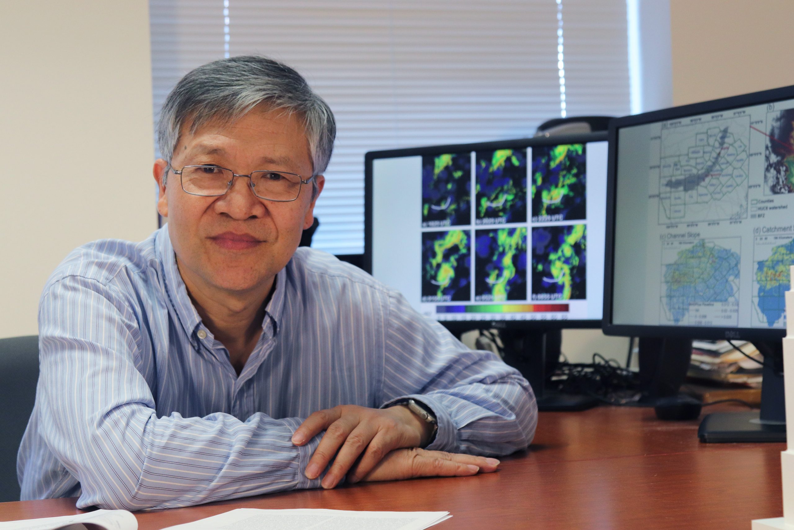
Jackson School Professor Zong-Liang Yang has spent his career modeling the climate. After the devastating floods that struck Texas Hill Country on July 4, 2025, killing at least 139 people, he has become an advocate for a new approach to flood prediction. The method uses data that’s already being collected to predict how high flood waters could rise on a local level, and potentially do so days in advance.
The approach involves adapting methods that Yang has used to successfully simulate the Memorial Day and Halloween floods that struck Wimberley, Texas in 2015 when the Blanco River experienced historic flooding after intense rainstorms.
The simulation results are described in a 2018 study published in the Journal of Hydrometeorology, which Yang conducted with then-graduate student Peirong Lin, and researchers from the National Oceanic and Atmospheric Administration (NOAA). The team drew on an array of data that captured weather patterns, river flow, soil moisture and local terrain and used it to create physical models of the floods.
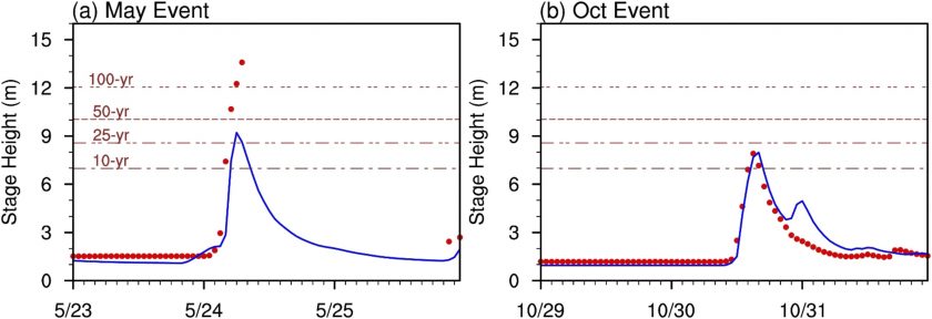
At its peak, the Memorial Day flood reached an estimated 44.9 feet (the river gauges failed at 40 feet). The Halloween flood reached 26 feet. In their model, Yang and his students were able to accurately reproduce the height of the rising river during both events at a range of river gauges over three days, from May 23-25 and October 29-30.
Their simulation performed the best at gauges that experienced especially rapid increases in river level — the same conditions that made the July 4 floods of 2025 so devastating.
Yang said that following a similar approach with real-time data could provide highly accurate and localized forecasts for future flooding events in Central Texas potentially days in advance. The forecasts could be refined and updated as the day of an expected flood drew closer.
Since last year’s July 4 flood, Yang has taken part in task forces that have helped inform policy makers. But he is still seeking funding to see how well his approach works for forecasting rather than simulating events that have already happened.
With improvements in machine learning and AI, he says there is more potential to increase the accuracy and accessibility of these predictions.
We talked with Yang to learn more about forecasting rising flood water, and how the July 4 floods of 2025 motivated him to push for improved forecasting in Central Texas.
Q: How has the July 4 flood affected how you view your flood forecasting research?
A: The July 4 flood made this work feel much more urgent and personal. For many years, my group has studied land surface processes, soil moisture, hydrologic modeling and flood prediction. After the July 4 disaster, the question became sharper: How can we turn that science into information that protects people? The tragedy showed that warnings alone are not always enough. We need forecasts that are more local, more impact-based and easier to act on. We need to know not only that rain is coming, but how the landscape, rivers and vulnerable locations may respond.
Q: Before the July 4 floods, the National Weather Service had already warned about potential flash flooding. What did those warnings provide? How is your approach different?
A: The National Weather Service (NWS) did issue important warnings. Those warnings told people that dangerous rainfall and flash flooding were possible, and later that life-threatening flooding was occurring.
What I am proposing is not a replacement for NWS warnings. It is a way to add more localized, actionable information to them. A warning may say that flash flooding is possible in a broad area. What communities also need to know is: Which river reaches (portions of the river) are most likely to rise? How high could the water get? Which campgrounds, low-water crossings, roads or neighborhoods are most at risk? And how might that picture change over the next several hours?
My approach is to connect meteorological forecasts, rainfall observations, soil moisture, terrain, river routing and flood mapping into one system that can update as new data arrive.
Q: Where does the data for your model come from?
A: The data come from several sources that already exist. We can use NWS and NOAA Weather Prediction Center forecasts, radar rainfall products such as MRMS, NASA satellite observations such as GPM for precipitation and SMAP for soil moisture, the National Water Model for streamflow and river-stage guidance, U.S. Geological Survey (USGS) stream gauges, and local terrain and geospatial data.
The key is that one dataset is not enough. Flood prediction requires putting many pieces together: How much rain is falling, where it falls, how wet the ground already is, how steep the terrain is, how fast water moves through channels, and where people and infrastructure are located.
Q: Would you need to know the specific locations in advance? In how widespread of an area could you provide forecasts?
A: We do not need to know the exact flood location days in advance. We can begin with broad regional risk several days ahead, then narrow the focus as forecasts and observations improve.
For example, several days before an event, the system may identify the Texas Hill Country as a region of concern. As the event approaches, it can focus on specific watersheds, river reaches, campgrounds, low-water crossings and communities. In principle, this can be applied across Central Texas or the entire Texas Hill Country, but the most useful forecasts would be tailored to vulnerable places where flood impacts are greatest.
Q: How useful could this information be to someone on the ground?
A: People on the ground need information that helps them decide what to do. A forecast of “heavy rain” is useful, but it is not always enough. A forecast that says a specific river reach may rise rapidly near a campground or low-water crossing is much more actionable.
For emergency managers, this could help prioritize evacuations, road closures, rescue staging and public messaging.
For residents, it could help make the warning more personal and urgent: not just “there may be flash flooding,” but “this location may become dangerous soon.”
Q: How could machine learning or AI help?
A: AI can help in several ways. It can rapidly combine many data streams, detect high-risk patterns, correct systematic model biases, and help generate flood impact maps more quickly. It can also help translate technical forecasts into clearer risk messages for different audiences.
But AI should not replace physics.
Flooding is governed by real physical processes: rainfall, infiltration, runoff, river routing and terrain. The strongest approach is a hybrid one, where physics-based models provide the foundation and AI helps improve speed, accuracy, bias correction, pattern recognition and communication.
Q: What do you need to test your approach in real time and see how well it works for forecasting future floods, not just reproducing past ones?
A: We need support to build and test a prototype real-time system. That means continuously ingesting weather forecasts, radar and satellite rainfall, soil moisture, National Water Model outputs, stream gauges and local geospatial data; running the system during future storms; and comparing its forecasts with observed river rises and flood impacts.
The 2018 study showed that the physical modeling framework can reproduce major Hill Country flood behavior when driven by good observational data. The next step is to test whether a similar framework, enhanced with real-time data and AI, can provide useful forecasts before and during an event. That requires funding, computing support, access to real-time data streams, and close partnership with agencies such as NWS, Texas Division of Emergency Management, NASA, USGS and local emergency managers.
The University of Texas at Austin
Web Privacy | Web Accessibility Policy | Adobe Reader