About the Research
Mapping Hidden Fault Systems in the Heart of the Himalayas
An NSF-supported investigation into the lineaments of central Nepal: Unlocking the structural architecture of one of Earth’s most seismically hazardous regions
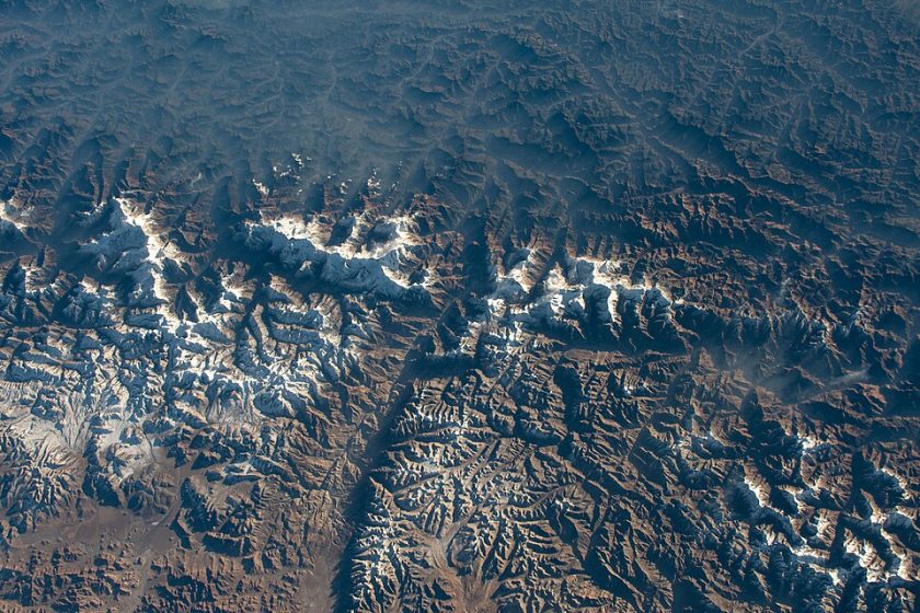
The Scientific Problem
What Are These Linear Features – and Are They Faults?
Central Nepal hosts striking linear geomorphic features, called lineaments, that cut across the Himalayan mountain belt. The Gaurisankar, Thaple, Judi, and Pokhara lineaments, along with strike-slip faults in the Melamchi Valley, may represent an unrecognized class of orogen-scale fault systems.
Our central hypothesis is that these are Cenozoic, right-lateral strike-slip fault systems accommodating differential crustal motion across the Himalaya, with profound implications for earthquake hazard and our understanding of how continents collide.
The lineaments vary considerably in length. Some extend for only a few tens of kilometers, while others can be traced for hundreds of kilometers across the Himalayan mountain belt. Several cross major Himalayan geologic boundaries and continue across valleys, mountain ranges, and in some cases toward the foreland. Their great length is one reason we are interested in understanding whether they reflect structures deep within the crust.
Many Himalayan lineaments became apparent with the development of satellite imagery and remote sensing in the 1970s and 1980s. From above, researchers recognized unusually straight valleys, aligned river segments, abrupt changes in topography, and other linear features cutting across the dominant east–west grain of the Himalaya. Early studies used Landsat imagery; today we can combine much higher-resolution satellite data, digital elevation models, geologic maps, and geophysical observations to examine them in much greater detail.
Sometimes, but often not as a single obvious feature. A lineament that looks striking on a regional satellite image may extend for many kilometers across rugged terrain, making its overall geometry hard to recognize on the ground. In the field, however, we may find pieces of the larger pattern: straight valleys, aligned streams, fractured or faulted rocks, displaced geologic units, unusual topographic breaks, or zones of brittle deformation. One goal of our project is to determine which remotely mapped lineaments correspond to actual geologic structures.
The best-known Himalayan faults, including the Main Frontal Thrust, Main Boundary Thrust, and Main Central Thrust, generally run roughly parallel to the Himalayan mountain belt and are fundamental components of the India–Asia collision. Many of the lineaments we are studying instead cut across the range, commonly trending northwest–southeast or northeast–southwest. Others may represent strike-slip or tear structures rather than the large thrust faults traditionally emphasized in Himalayan tectonics models.
Importantly, a lineament is not automatically a fault. It is a linear landscape or geophysical feature whose origin must be tested. Our project asks a very basic question: Fault or not?
Possibly, but that is one of the questions we are investigating. Previous studies have proposed links between transverse Himalayan structures and earthquake activity, and earthquake epicenters occur near some mapped lineaments and their intersections with major Himalayan faults. Researchers have also suggested that transverse structures may help divide the Himalayan arc into segments that behave differently during earthquakes.
However, proximity alone does not prove that a particular lineament produced an earthquake. We are combining field geology, remote sensing, earthquake locations, geophysics, and spatial analysis to determine which lineaments represent active or inherited faults, and whether they influence where Himalayan earthquakes occur.
Why These Lineaments Matter for Earthquake Hazard
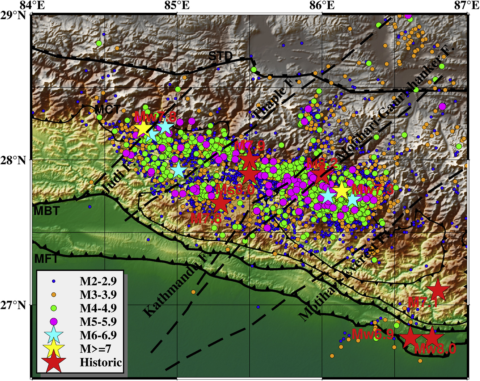
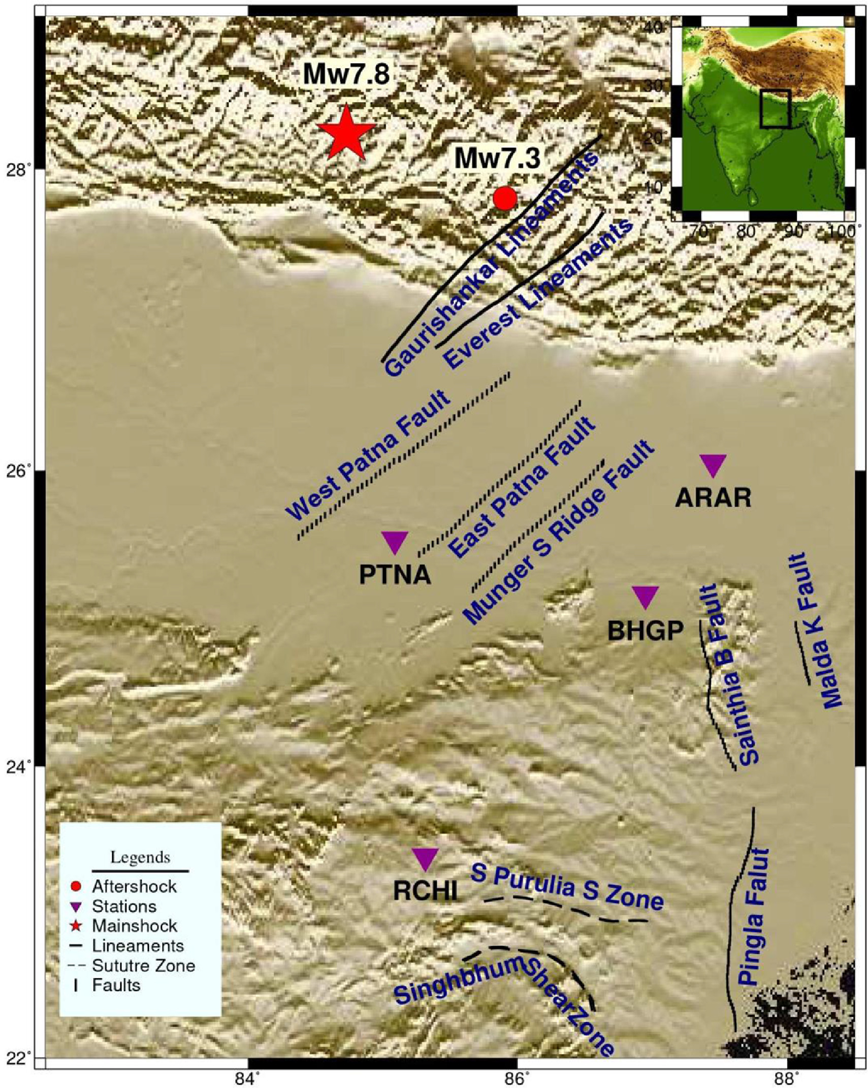
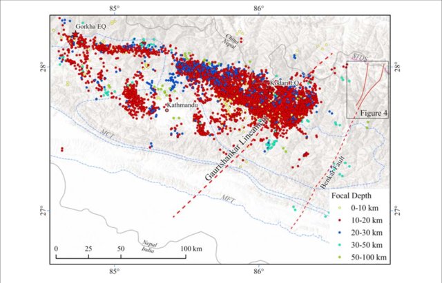
The 2015 Nepal earthquake sequence began with the Mw 7.8 Gorkha earthquake on 25 April 2015. Its rupture stopped abruptly near the eastern edge of the Kathmandu Valley, leaving elevated stress on the adjacent fault segment. Seventeen days later, that stress was released farther east in the Mw 7.3 Dolakha earthquake. These events renewed interest in Himalayan lineaments and their possible role in segmenting rupture. Several studies have interpreted the Judi and Gaurisankar lineaments as structural boundaries that may have influenced rupture propagation, and have noted concentrations of aftershocks near intersections between transverse structures and major Himalayan faults.
Despite this compelling spatial association, the field and geochemical evidence needed to confirm these interpretations remains absent. This research directly fills that critical knowledge gap. The gallery highlights published studies examining the relationship between Himalayan lineaments, rupture boundaries, and the 2015 Gorkha earthquake sequence.
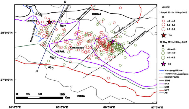
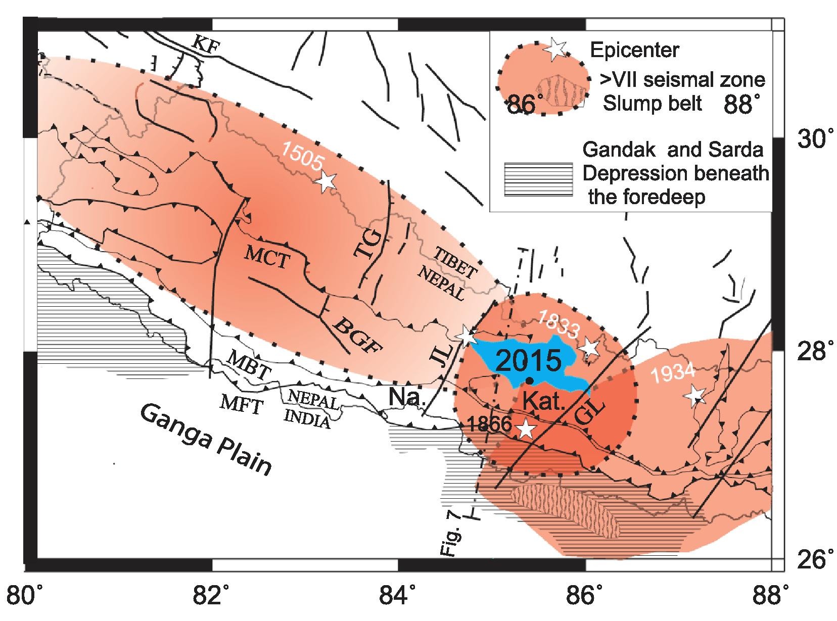
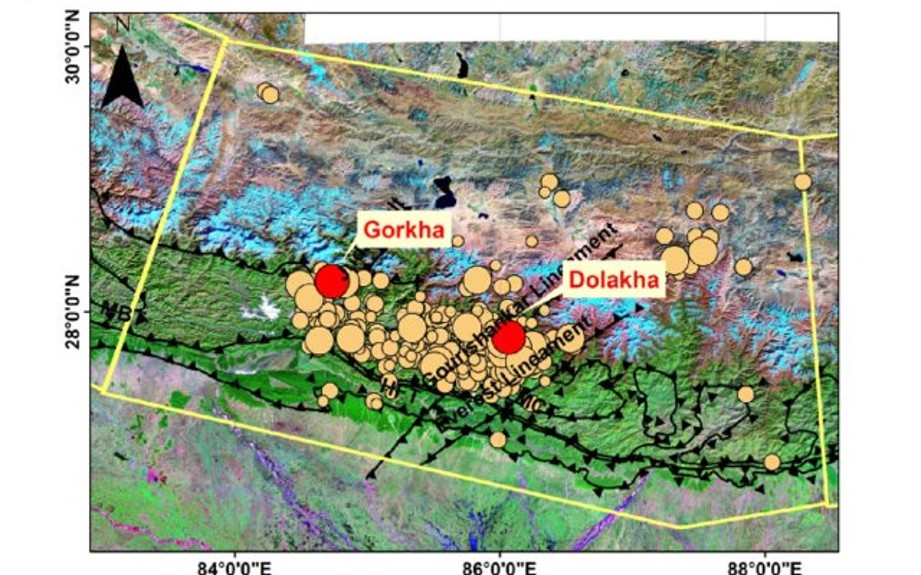
HUBBARD ET AL. (2021)
Beyond Thrust-Only Models
Conventional models of Himalayan seismicity emphasize thrust faulting along the Main Himalayan Thrust (MHT). Lineaments introduce a more distributed, structurally diverse pattern of active deformation, including possible orogen-scale strike-slip systems that segment the MHT and its hanging-wall structures.
If confirmed as through-going faults, these structures transform our understanding of how India-Asia convergence is accommodated and how large earthquakes initiate and terminate.
North American Analogs
Long-lived crustal lineaments that control deformation, seismicity, and resources are well documented in North America: the Lewis and Clark Line, Olympic-Wallowa Lineament, Jemez Lineament, and New York-Alabama Lineament. These serve as structural analogs, underscoring that inherited crustal corridors can govern fault segmentation across hundreds of millions of years.
Insights from Nepal’s active orogen are directly applicable to interpreting reactivation hazards in North America and other convergent margins.
The Lineaments of Central Nepal: Where we will focus
Four primary lineaments form the backbone of this investigation. Each presents a distinct structural character and seismic associations.
| Name | Strike | Length (km) | Seismic/Structual Significance |
|---|---|---|---|
| Gaurisankar | NE-SW | 380 | Eastern boundary of 2015 Gorkha rupture |
| Thaple | NE-SW | 280 | Some solutions place the Gorkha earthquake epicenter on this lineament near MCT intersection |
| Judi | NE-SW | 170 | Western boundary of 2015 Gorkha rupture; linked to Gardi tear fault |
| Pokhara | NE-SW | 160 | Intersects MCT near epicenter of 2021 MLv 5.3 Lamjung earthquake |
From Observation to Investigation
Field Discovery: A Strike-Slip Fault Zone in Melamchi Valley
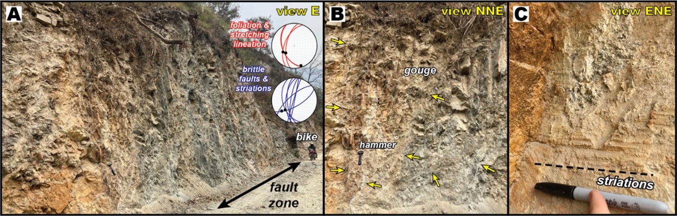
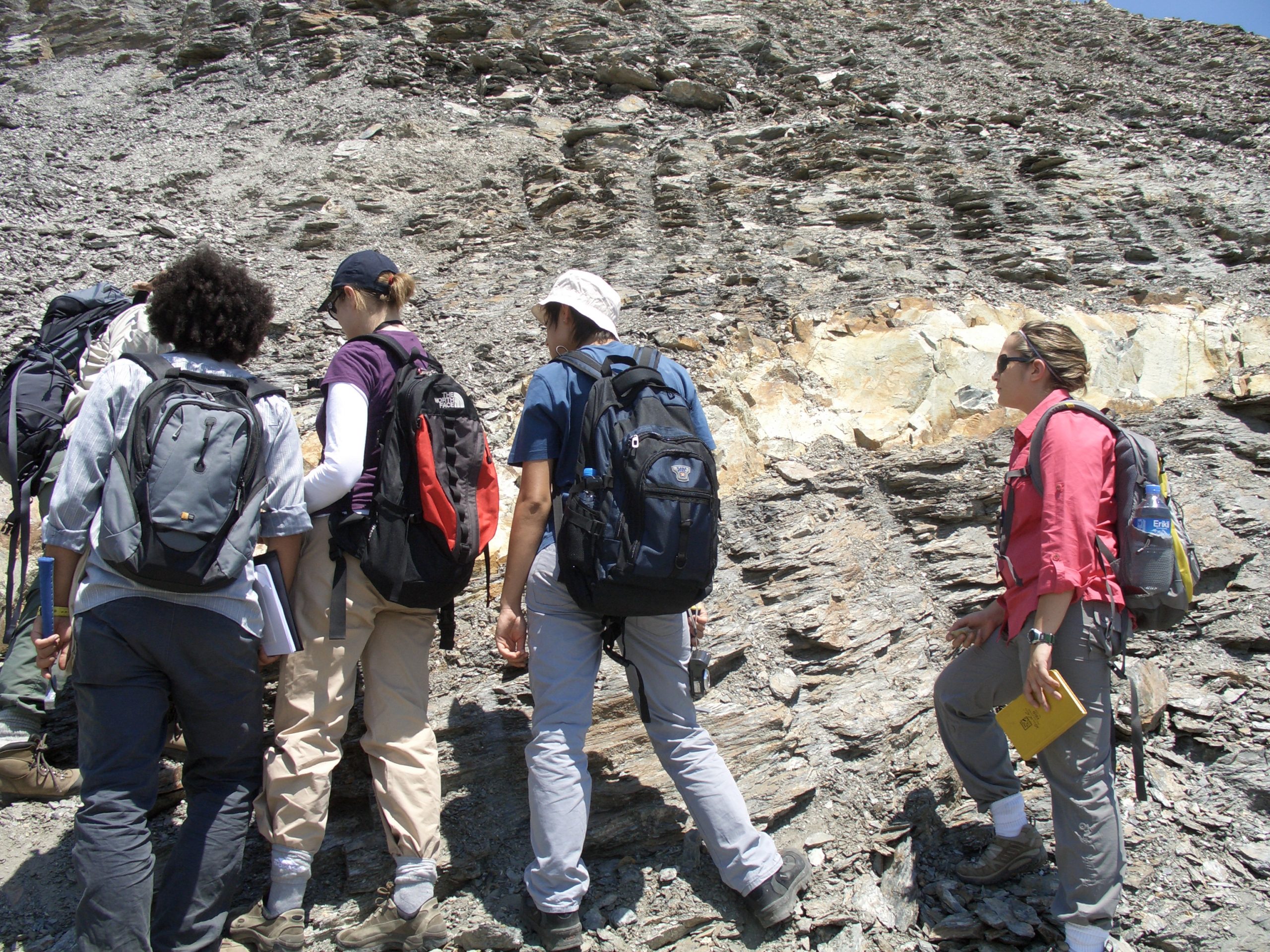
In March 2025, the PIs conducted preliminary fieldwork directly NE of Kathmandu in the Melamchi Valley, a landscape defined by N- to NE-trending linear drainages, ridges, and high landslide density. The team documented N- to NE-striking brittle fault zones with dominant strike-slip kinematics.
A key exposure in the southern Melamchi Valley reveals a >100-m-wide, NE-striking, subvertical fault zone within Lesser Himalayan garnet schist and gneiss, featuring a ~10-m-wide core of gouge. Fault-surface striations plunge 24–39° to the SW — compelling evidence of orogen-scale strike-slip faulting requiring further systematic investigation.
Three Objectives, One Integrated Research Plan
Compile remote sensing, GIS, and published data to map the four lineaments and Melamchi Valley faults, assessing spatial correlations with earthquakes, landslides, and infrastructure.
Conduct 1:25,000-scale structural mapping each summer, documenting kinematics, displacements, and cross-cutting relationships across all targeted lineaments.
Apply petrography, mineral chemistry (EPMA), and geo-/thermochronology (U-Th/Pb monazite, ⁴⁰Ar/³⁹Ar muscovite) to constrain deformation timing and strain intensity.
Multi-Scale Techniques to Decode Fault History
We combine geospatial analysis, field mapping, and laboratory methods to investigate whether Himalayan lineaments represent active or inherited structures, and how they influence the evolving mountain belt.
GIS & Remote Sensing
Mapping the Himalaya from Space
ArcGIS, Google Earth Engine, PyGMT, and Copernicus datasets integrate satellite imagery, digital elevation models, and published geologic data to build reproducible lineament maps and compare them with geologic and hazard datasets.
Structural Field Mapping
Testing Lineaments on the Ground
Annual field campaigns provide detailed structural mapping at 1:25,000 scale. We document fault kinematics, displacement, cross-cutting relationships, and collect GPS-located rock samples to test whether mapped lineaments correspond to geologic structures in the field.
EPMA & EBSD
Reading Deformation at the Microscale
Electron probe microanalysis (EPMA) and electron backscatter diffraction (EBSD) are used to characterize mineral chemistry, microstructures, and crystallographic fabrics in rocks collected across key lineaments. These observations help us identify deformation processes and connect structures observed at the microscale with faults and fabrics mapped in the field
Geo-/Thermochronology
Putting the Structures in Time
Geochronologic and thermochronologic analyses constrain the timing of rock formation, deformation, and exhumation across Himalayan lineaments. By combining these age constraints with field relationships and microstructural observations, we can test when structures formed, whether they were reactivated, and how they relate to the long-term evolution of the Himalaya.
A Collaborative Research Program
US-Nepal Collaboration
Elizabeth J. Catlos – PI
UT Austin, Jackson School of Geosciences. International leader in Himalayan tectonics, geochronology, and metamorphic petrology. Leads scientific design, monazite dating, and UT student mentorship.
Peter J. Haproff – Co-PI
Pomona College in Claremont. Field-based structural geologist specializing in Cenozoic Himalayan and Tibetan tectonics, EBSD microstructural analysis, and neotectonics. Leads structural mapping.
Ananta Gajurel – Collaborator
Tribhuvan University. Expert in Himalayan structural geology, geomorphology, and geohazards. Former President, Nepal Geological Society. Serves as Senior Scientific Collaborator and Field Science Lead.
Krishna Pandey – Collaborator
Dept. of Mines & Geology, Nepal Government. Provides field logistics, permitting, and integration with Nepal’s geological databases and hazard assessments. Field Logistics Liaison.
Developing the Next Generation of Geoscientists
This project provides transformative research experiences for graduate and undergraduate students across all phases: GIS mapping, field campaigns in Nepal, laboratory analysis, and science communication.
ArcGIS, Google Earth Engine, PyGMT training through coursework and research
Cross-cultural experience in Nepal, broadening global scientific perspective
Direct preparation for careers in geoscience, hazard assessment, and public policy
Open Science for a Safer Nepal
Nepal faces the prospect of a future Mw ~9 earthquake. Current seismic hazard assessments in central Nepal rarely incorporate mapped surface lineaments. This project delivers open-access fault and lineament maps in ArcGIS and Google Earth formats, made available through the UT Austin Geodata Portal and Libraries Map Collection, directly relevant to infrastructure planning, disaster preparedness, and risk mitigation.
Annual Wrap-Up Meetings
One-day stakeholder events in Nepali towns near field sites, engaging local officials, infrastructure developers, scientists, and communities in lineament hazard awareness.
Government Data Sharing
Results, shapefiles, and geological maps shared directly with Nepal’s Dept. of Mines & Geology for integration into national hazard assessments.
AGU Topical Sessions
Annual sessions at the American Geophysical Union to share methods, tools, and findings with US and international researchers studying lineament systems worldwide.
The Road Ahead: What Comes Next?
Three Years, Four Lineaments
Each summer field campaign spans four weeks with a team of PIs, graduate students, and Nepali collaborators.
Year One
Judi & Thaple lineaments. Structural mapping and sampling where lineaments intersect the MCT. Focus on understanding the 2015 Gorkha earthquake rupture boundaries.
Year Two
Gaurisankar lineament & Melamchi Valley. Investigate the 2015 Dolakha earthquake zone and expand upon the PIs’ preliminary strike-slip fault observations.
Year Three
Pokhara lineament. Characterize the structure associated with the 2021 Lamjung earthquake and complete the four-lineament dataset for integrated analysis.
If These Are Faults, Everything Changes
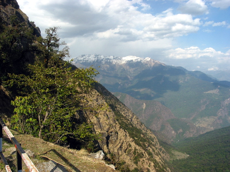
If the lineaments targeted in this project are geomorphic landscape features or smaller-scale faults, the data will be equally valuable for dispelling misconceptions about their origins. Regardless of the outcome, the findings will advance knowledge of the region’s geodynamics and seismic potential.
This project is among the first systematic, multi-method investigations of Himalayan transverse lineaments integrating remote sensing, field geology, microstructural analysis, and geochronology. Its outcomes will either confirm an unrecognized component of Himalayan tectonics, reshaping earthquake hazard models for a region of 30 million people, or rigorously rule it out, establishing an equally important baseline for future research
This material is based on work supported by the U.S. National Science Foundation under Grant No. 2548018.
Any opinions, findings, and conclusions or recommendations expressed in this material are those of the author(s) and do not necessarily reflect the views of the National Science Foundation.