Research
 |
The Rempe research group focuses on hydrologic processes in the shallow subsurface and their influence on ecology and landscape evolution at a variety of time scales. Below is information about some ongoing projects. |
Ecological Significance of Rock Moisture
 |
In many forested landscapes, thin soil mantles coat a hydrologically dynamic weathered and fractured rock zone. Rock moisture, as opposed to soil moisture, is the exchangeable water stored within weathered and fractured bedrock. Storage of rock moisture occurs in fractures and within the rock matrix and is depleted by evapotranspiration, which influences vegetation dynamics and the atmosphere, and drainage, which recharges groundwater and sustains stream flow during dry periods. In a heavily instrumented hillslope in northern California, we use a variety of tools, including repeat downhole neutron moisture gauge surveys, to directly document changes in rock moisture up to depths of 25 m and relate those changes to direct measurements of vegetative water use and groundwater, streamflow, and soil moisture dynamics. |
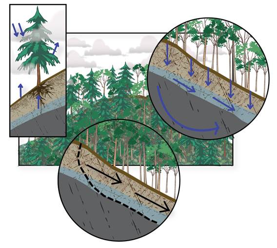
Controls on the Bottom Boundary of the Critical Zone
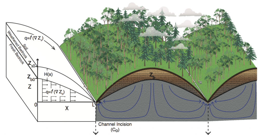 |
As the Earth’s surface evolves, the development of a weathering front into underlying fresh rock strongly influences soil generation, the availability of water to ecosystems and the atmosphere, erosional processes, and even global climate via silicate and carbonate weathering fluxes. Yet, despite its importance in defining the bottom boundary of the hydrologically dynamic Critical Zone, little is known about what controls the evolution of the weathering front under actively eroding landscapes. Our group is investigating mechanisms for feedbacks between the evolution of the Earth’s surface and subsurface weathering fronts. |
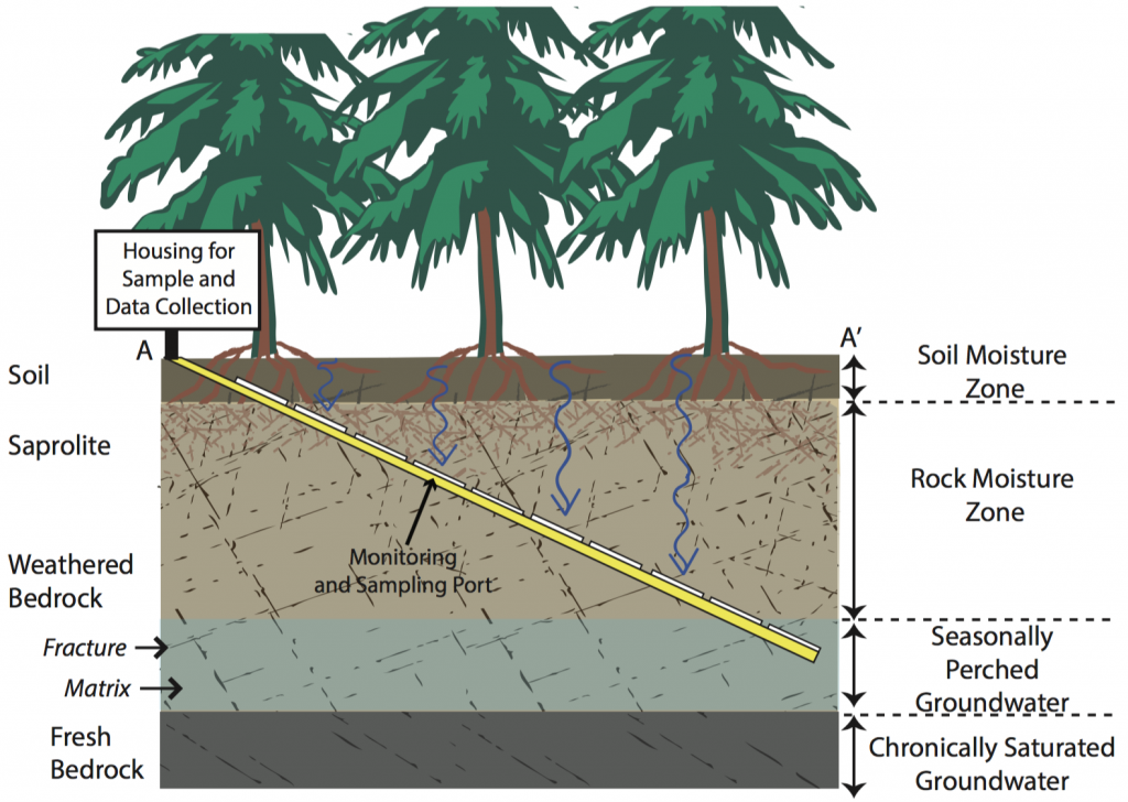
Transport of Water and Solutes through Fractured Rock
|
|
The chemical composition of stream water reflects the pathways through which water traveled through a landscape and contributes to our understanding of the physical, chemical, and biological processes that alter rock in the subsurface. Samples of soil moisture and groundwater provide us with part of the picture, but in uplands environments where much of the runoff occurs through weathered and fractured rock, we lack direct observations of water fluxes and chemistry in the unsaturated zone. In a heavily instrument hillslope in Northern California, we installed sensors and samplers in an inclined borehole within fractured, weathered rock to document the evolution of water through the unsaturated zone. |
Geophysical Imaging of Landscape Scale Patterns of Weathering
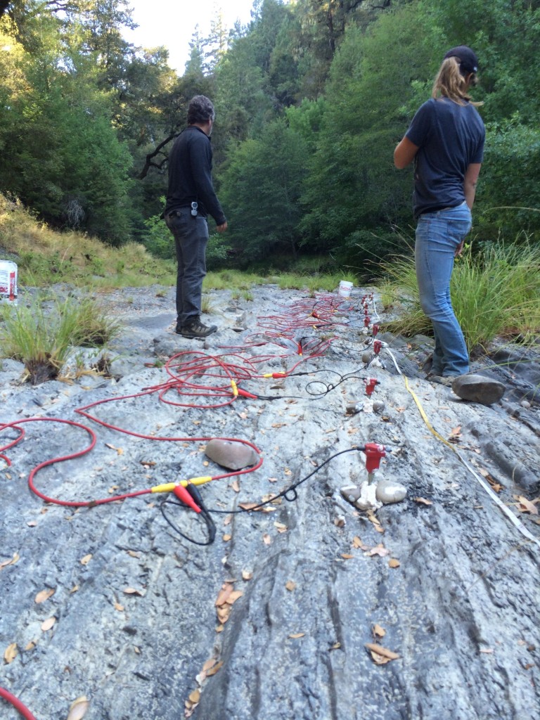
Seismic imaging at the Angelo Reserve Photo Credit: Ryan Armstrong |
In an ongoing collaboration with the Wyoming Center for Environmental Hydrology and Geophysics and the Eel River Critical Zone Observatory, we are measuring the structure of the weathered zone within hillslopes using near-surface geophysical tools. We seek to document spatial patterns of rock properties in diverse lithologies, climates, and tectonic histories to understand the mechanisms that lead to systematic patterns of weathering across landscapes. We rely primarily on electrical resistivity and seismic velocity to understand how fluids and pore space are distributed within the subsurface. These field scale geophysical data along with samples and monitoring data from boreholes are used to link the observed rock properties to the suite of weathering processes from which the properties were derived. |