Background
Site Description
The sample site is located closer to the distal end of the West Bull Creek watershed near the mouth of the watershed. However, it has a distinct catchment from which water discharges. The water at the Loop 360/2222 spring is not representative of the water of the entire watershed. The spring emerges from a roadcut that was made in 1976. It is estimated that the water started discharging from that location shortly after the road rut was made. The water emerges from high on the road cut and travels approximately 30 meters to the ground surface, though the water drags along the surface of the road cut forming the travertine being sampled.
There is a significant amount of foliage consisting of mosses and ferns growing on or near the travertine which significantly increases in the spring months. Cyanobacteria and diatoms have been located and some were identified on the travertine. Though the algal and bacterial species have largely not been identified and the extent to which the presence of these species affects travertine geochemistry has not yet been fully understood. The site is located right next to a major highway. Highway pollutants or debris could be transferred or blown onto the travertine, though this has yet to be identified at the sample site.
The growth of actively precipitating travertine is necessary for this research. There are multiple travertine springs in the greater Austin area, however, the site at loop 360/2222 was chosen as it provides information on the change of water quality through a known catchment for a known time. This allows for the ability to compare the construction, and the age of infrastructure within the catchment with the geochemical signal of the water within the travertine. Loop 360/2222 is also seemingly close to a constant flow of water from a spring and has an inferred time span with the appearance of annual layering within the sample. Since the last sampling existing water infrastructure has continued to age and grow in the catchment. Currently, a longer record of the water geochemistry of that spring is available, having that record of spring water geochemistry to compare to the historical record of the travertine would allow for a better understanding of the strength of travertine as a proxy in that area.
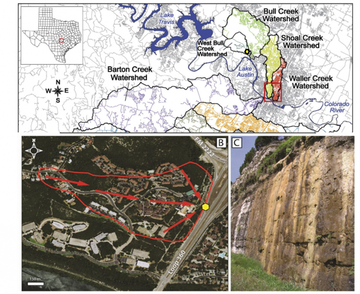
Figure 3: On the left is an aerial map of the catchment of Loop 360/2222 with water flow paths in red and the spring indicated as a yellow hexagon. On the left the precipitating travertine and spring (DeMott, 2007)
Travertines as a Proxy
A travertine is defined as a chemically precipitated limestone formed from springs and seepages around streams and rivers. Travertine consists of calcite or aragonite and precipitates from the invasion or degassing of CO2 leading to CaCO3 supersaturation in water resulting in the formation of travertine on a submerged surface (Pentecost, 2005). Travertines are also one of the fastest growing rocks, at Loop 360/2222 growing up to 1.5 cm per year. Precipitation of travertine requires significant degassing or invasion of carbon dioxide resulting in a supersaturated fluid with respect to calcium carbonate. A certain pH and alkalinity range as well as gypsum and the presence of biota in the system could also potentially affect the precipitation of travertine (Yan et al., 2021; Canatoni et al., 2016).
Travertine growth may be affected by biota, vegetation, the thickness of water sitting, or flowing across the surface of the travertine, and temporal and seasonal effects, such as temperature and aridity, may also affect the growth of travertine precipitation. Travertines have been used to determine the deposition environment and source of the water components (Golubic et al., 2008; Deininger et al., 2012; Özkul et al., 2013; Şener et al., 2021, Miller, N et al., 2021). Also, because the Glen Rose Limestone formation. does contain gypsum which could affect the diffusion boundary layer and the resulting in a smaller amount of precipitation of travertine (Yan et al., 2021)
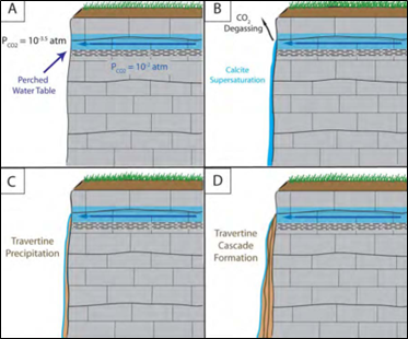
Figure 2: Diagram of travertine formation at the Loop 360/2222 sample site (DeMott, 2007)
Biotic Influence
Present at the site is the appearance of mosses and ferns growing near or on the travertine surface. Roots of vegetation and mosses likely have left porosity within the travertine sample. (Golubić et al., 2008). The presence of various algae like diatoms and bacteria, such as cyanobacteria may form biofilms and may also be present on the sample. Though no significant specific characterization of the biotic life has been made. presence of biota on the travertine is known. Since the travertine sample taken at 2006 is highly porous it is likely that certain biotic species grew and then left behind porosity after the travertine surface could no longer support their growth. Some diatoms and algae have been encouraged to grow with higher nutrient availability in urbanized waters, however, this is not always true of urbanized springs. Similarly, if nutrient supply is taken out of water discharging in the spring, this could also limit the growth of algae and other biotas (Mendoza, 2017).
Infrastructure Change
Higher municipal supply water in urban settings has been linked to leakage of municipal water from water infrastructure or pipes. The leakage of pipes may in part be due to the density of the water infrastructure and also the age of the infrastructure after it has been laid down (Christian et al., 2012). Development in the catchment is relatively new compared to other Austin area watersheds, like the Waller Creek watershed. This development has continued into the present since the construction of the road cut in 1976. The rate of evolution of water chemistry toward that of urban water in Loop 360/2222 can highlight the rate at which water chemistry changes due to the implementation of relatively newer water infrastructure and will identify the rate and extent of water infrastructure failure depending on the percentage of municipal supply water discharging out of the spring.