Background
Highland Ecuador is one of the most volcanically active regions on earth with some 20 volcanos exhibiting evidence of eruptive events since the beginning of the Holocene (Hall et al. 2008). Through the millennia, the intense and frequent volcanic episodes have shaped the nature of human occupations in the region. Tephrochronology has been a useful tool in both dating and interpreting archaeological evidence in the region but relies heavily on the accurate identification and correlation of eruptive episodes. The application of LA-ICP-MS to tephrochronology has the potential to aid accurate archaeological interpretations and allow us to either confirm or reject long-held interpretations based on the geochemical signatures of corresponding tephras.
Some of the greatest volcanic impacts on human populations in Ecuador occurred after the 800 BP eruption of Quilotoa volcano, the largest volcanic eruption to occur in South America since the beginning of the Holocene (Mothes and Hall 2008). The eruption, roughly calibrated to AD 1280, spread ash more than 1-mm thick across an area of 810,000 km2 and caused widespread abandonment across much of the northern Ecuadorian highlands (Mothes and Hall 1998, 2008). Perhaps one of the most consequential results of the Quilotoa eruption was its impact on the wetland farming practices of the people of the equatorial regions of the Inter-Andean valley. Wetland fields, known locally as camellones, were comprised of a series of parallel canals and ridges and covered thousands of hectares of the poorly drained flats of the Inter-Andean valley (Figure 1). Though likely one of the dominant farming practices in the region prior to the Quilotoa eruption, many of the fields utilized for wetland agriculture closer to the eruption were inundated by the Quilotoa ashfall and abandoned shortly after. However, some areas further from the eruption received little ashfall yet wetland agriculture was abandoned nonetheless. The eruption of Quilotoa, sociocultural changes, and environmental or climatic perturbations have all been proposed as possible explanations for the abandonment of wetland agriculture (Knapp and Mothes 1998).
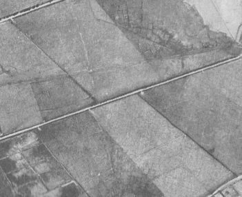
Figure 1: Historic aerial image showing the extent of wetland field remnants near the town of Cayambe (from Caillavet 2008).
Although Quilotoa has been identified as having potentially the greatest impact on the abandonment of wetland farming, the eruption occurred during a period of intensive volcanic activity for the northern highlands. The eruption also corresponds with the end of the Medieval Climate Anomaly and the gradual transition to the Little Ice Age. This raises questions about the influence other volcanic events and climatic perturbations might have had on the management of wetland agricultural systems. Figure 2 shows the erupted mass in megatons from the known eruptions with a magnitude greater than 4 in mainland Ecuador over the last 10,000 years and their latitude. Each bubble represents an eruption and the size of the bubble corresponds to its estimated erupted mass. The gray boxes (P1-P8) approximate the climate periods inferred from palynological evidence from the Sucus bog in Papallacta (Ledru et al. 2013, 2022). The shaded red square denotes the latitude, duration, and intensity of wetland farming based on archaeological and historical evidence. The practice intensified leading up to the Quilotoa eruption and gradually disappeared by the end of the 19th Century. Note that Cayambe volcano, located in the heart of the wetland farming region, had three large eruptions during the time that wetland fields were most active. The possibility that multiple high magnitude volcanic eruptions occurred at or around the same time as the Quilotoa eruption highlights the importance of differentiating ashfall events in archaeological contexts to better understand the events that led to the disappearance of wetland agriculture.
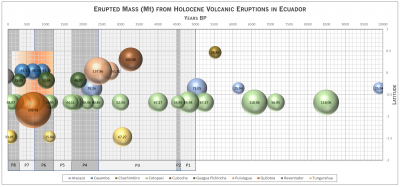
Figure 2: Erupted Mass in Megatons from Ecuadorian Volcanos During the Holocene (based on data from VOGRIPA 2022).
Tephra chronology has proven to be a powerful tool for the dating of archaeological materials. It is especially useful for dating archaeological contexts such as wetland agricultural features in which organic material suitable for 14C dating do not preserve well or when dealing with a sequence of events on annual or decadal scales, below the resolution of even the best 14C dates. Tephrochronology also allows for the correlation of events across broad spatial scales in any location where ashfall occurred either through visible macrostrata, less perceptible microstrata, or the recovery of cryptotephra. At the macro-scale, this can be done through visual identification using texture and mineral inclusions. But this technique is somewhat qualitative, prone to sampling error, is complicated by post-depositional turbation and weathering, and is unreliable at the microscale.
Imaging and geochemical sampling techniques focused on the trace element composition of tephra can provide precise qualitative sampling of tephra and a geochemical “fingerprint” that can be statistically correlated with other samples to positively identify eruptive episodes. In recent decades, the application of Laser Ablation Inductively Coupled Plasma Mass Spectrometry (LA-ICP-MS) has been shown to be a reliable method for correlating eruptive episodes using volcanic glass shards as small as 50 microns (Pearce 2014; Pearce et al. 1996, 2004, 2007; Westgate and Pearce 2017). Individual glass shards can be selected either through intensive extraction or geoimaging procedures and sampled through LA-ICP-MS. By applying LA-ICP-MS to tephra samples from archaeological sites in the northern highlands, we can better date archaeological material, temporally constrain paleoenvironmental proxies indicative of changes in climate, and investigate the possibility of unrecognized volcanic impacts on human occupations.
The Northern Volcanic Zone (NVZ), can be divided into three major geologic zones, the Western Cordillera, the Eastern Cordillera, and the Inter-Andean valley (Figure 3). Recent studies have looked extensively at the variable geochemistry from a number of volcanoes within the Eastern Cordillera, Western Cordillera, Inter-Andean valley, and Back-Arc of the Ecuadorian Volcanic Arc (Ancellin et al. 2017; Bablon et al. 2022). They have noted variations in incompatible element contents and ratios of trace fluid-mobile and fluid-immobile elements with north-south and east-west distance from the subduction zone along the pacific coast. The reduction in crustal melting with distance from the trench results in a reduction of fluid-mobile elements. Bablon et al. (2022) utilized this concept to attempt to pinpoint source volcanos for distal tephras recovered in marine cores based on the trace element composition of glass shards in the tephras analyzed by LA-ICP-MS. Within the NVZ, there is across arc geochemical zonation with increases in incompatible element contents (e.g. Ba, Nb, Rb, La, Pb, Th) at greater distances from the subduction zone due to a reduction in crustal processing and a decrease in the ratio of more to less fluid-mobile elements (e.g. Ba/Th, Ba/La, Ba/Nb, Pb/Th, Li/Th) due to cooling magma (Ancellin et al. 2017; Bablon et al. 2022). By comparing trace element concentrations of these categories of elements from volcanic tephra, it is possible to approximate the relative location of the source volcano along the arc (see Figure 4 from Bablon et al. 2022 for an example). This method experiment follows Bablon et al.’s logic to attempt to distinguish the AD 1280 Quilotoa eruption from a Cayambe eruption potentially dated between AD 1290 and ~AD 1485 using LA-ICP-MS in order to determine what impact if any Cayambe volcano might have had on wetland agriculture (Samaniego et al. 1998; Vizuete Yepez 2020).
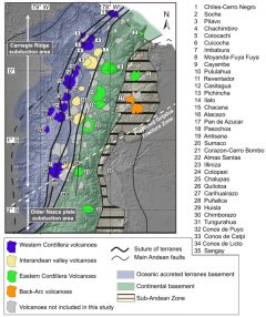
Figure 3: Map of the Northern Volcanic Zone from Ancellin et al. 2017 with Western Cordillera, Eastern Cordillera, And Inter-Andean valley volcanos highlighted.
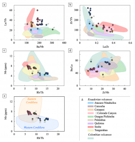
Figure 4: Incompatible Element Concentrations and More to Less Fluid-Mobile Ratios from Bablon et al. 2022.