Scientists Plan Major Research Program to Understand Earth’s Most Dangerous Hazards
November 8, 2022

The University of Texas at Austin has joined leading scientists on a bold new effort to understand Earth’s largest earthquakes and volcanic eruptions.

The plans were detailed in a new report published Nov. 7 with the backing of 55 universities.
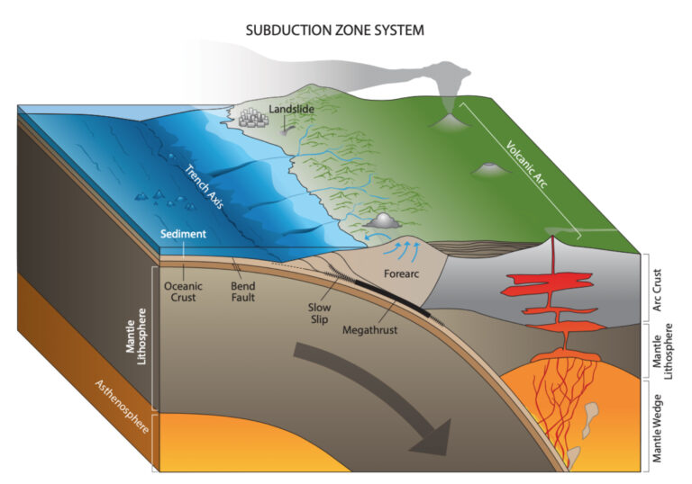
Demian Saffer, the director of the University of Texas Institute for Geophysics (UTIG) and one of the report’s many architects, said the initiative marked the start of a long-term, multinational effort to make hazard forecasting a reality at subduction zones, where the collision of tectonic plates increase the risk of earthquakes and other extreme seismic hazards.
“Our report [published today] shapes the future of fundamental science that underpins hazards posed by earthquakes, volcanoes, and landslides, through a major, multi-decadal scale program to address these grand challenges,” he said.
Named Subduction Zones in Four Dimensions (SZ4D), the initiative seeks to install massive arrays of undersea instruments aimed directly at earthquake hotspots in Chile, Alaska and the Pacific Northwest. Data from the instruments will give scientists a never-before-seen picture of Earth’s inner workings and help scientists create a new generation of predictive computer models.
Earthquakes, tsunamis and volcanic eruptions have caused catastrophic devastation throughout human history. Despite their potential to disrupt society, the science behind where and when they occur remains a mystery. The new report details scientific research priorities that can help solve the mystery, beginning with large-scale instrumentation at subduction zones in Chile and the U.S.
According to Emily Brodsky, a professor of Earth and planetary sciences at the University of California, Santa Cruz and chair of the SZ4D steering committee, the Chilean subduction zone is the primary target because it is the most geologically active of the three earthquake hotspots. The report recommends deploying instruments at all three sites, but most of the efforts are planned for Chile, which will host 70% of the instrumentation.
“We want to be able to translate what we learn in Chile to Cascadia and Alaska,” Brodsky said.
The SZ4D initiative has already begun building partnerships with Chilean scientists and international groups studying the subduction zone there.

In addition to instrument arrays, the report calls for researchers to study the sites’ geologic background, conduct laboratory experiments, and build computational models that integrate field observations and laboratory data.
According to Thorsten Becker, a professor at UT Austin’s Jackson School of Geosciences, major scientific advances in understanding subduction zone hazards could yield tangible benefits for communities in the affected regions. This includes possible forecasts of large earthquakes, volcanic eruptions, and landslides.
“We may never know exactly when the next big earthquake or eruption will happen, but the more we learn about these systems the closer we can get to building physics-based models that can quantify the degree to which these events are inherently predictable,” said Becker, who led the planning for SZ4D’s computational modeling component (the Modeling Collaboratory for Subduction) over the past two years.
Through the efforts of Becker, Saffer and a growing number of researchers and students at the Jackson School and its UTIG research unit, UT Austin is poised to play a key role in shaping the SZ4D initiative and the future of earthquake research.
The SZ4D initiative is organized into three working groups: Landscapes and Seascapes, Faulting and Earthquake Cycles, and Magmatic Drivers of Eruption. It also has two integrative groups: Building Equity and Capacity in Geoscience and Modeling Collaboratory for Subduction. The initiative includes 74 people from 55 universities and institutions. The next SZ4D community meeting will be held November 14 -16 in Houston.
Additional information is available on the SZ4D website at www.sz4d.org.
For more information, contact:
Constantino Panagopulos, University of Texas Institute for Geophysics, 512-574-7376
Anton Caputo, Jackson School of Geosciences, 512-232-9623.