
Battered But Not Broken
October 21, 2014
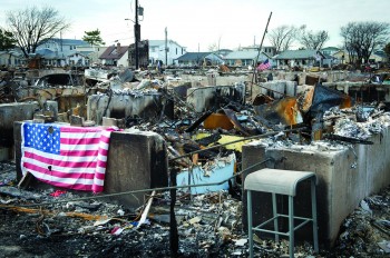
Hurricane Sandy may have wreaked havoc throughout Long Island in October 2012, but the massive storm did not seriously damage the offshore barrier system that controls the island’s erosion, found researchers with the University of Texas at Austin’s Institute for Geophysics (UTIG) and other scientific institutions.
The findings are based on pre-storm survey data compared with post-storm data acquired through a collaborative rapid response science mission to the south shore of Long Island led by scientists at UTIG, Adelphi University, Stony Brook University and other institutions in the New York metro area.
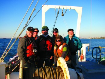
The purpose of the mission, conducted January 2013, was to assess the post-Sandy health of the offshore barrier system that protects New York Harbor and the southwestern Long Island region against damage from future storms. The team conducted marine geophysical surveys of the seafloor and shallow subsurface to map the sedimentary impact of the hurricane on the beach/barrier systems of selected bay, inlet and nearshore areas of the south shore of Long Island.
Using a CHIRP (compressed high-intensity radar pulse) sonar system and an even higher frequency seafloor mapping system supplied by Stony Brook University, the scientists used two research vessels to profile the seafloor and upper sediment layers of the ocean bottom. They surveyed three representative segments of the shoreface that protects Long Island, each segment about 15 meters deep, 1 mile offshore and roughly 6 square miles in size.
The storm, they found, did not significantly erode these sampled segments of shoreface.
“The shape of the bedforms that make up the barrier system did not change a whole lot,” said co-principal investigator John Goff, of UTIG. “Where we might have expected to see significant erosion based on long-term history, not a lot happened—nothing that ate into the shoreface.”
“The sand largely took the blow,” added co-principal investigator Jamie Austin, also of UTIG. “Like a good barricade, the barrier system absorbed the significant blow, but held.”
This was not the case in other storm-ravaged zones the Texas team has surveyed. When Hurricane Ike hit Galveston in 2008, the storm significantly disrupted the thin finer-grained sediment layer offshore, removing material underneath the shoreline in a way that exacerbated long-term problems of erosion.
Compared with Galveston, Long Island has a greater abundance of sand in its overall system. The storm churned up much of this sand and moved bedforms, but the scientists speculate that the greater abundance of sand helped the offshore barriers maintain their overall shape and integrity as erosional barriers.
Tempering this good news, the survey team also found evidence the storm brought new pollutants into the waters off Long Island. Heavy metals were detected in a layer of mud that the storm deposited offshore. Beth Christensen, of Adelphi University, traced the metals back to muds from Long Island’s South Shore Estuary Reserve, which has a long history of pollution from industry and human habitation.
The mission was the sixth rapid response science mission funded by the Jackson School of Geosciences at UT-Austin. (UTIG is a research unit within the Jackson School of Geosciences.) The missions place geoscientists on the scenes of natural disasters as quickly as possible to measure the often vanishing traces of hurricanes, earthquakes, tsunamis and other disasters.
“The faster we get out into the field to measure Earth’s response to naturally destructive events, the better we can relate data to the disasters,” said Austin.
Back to the Newsletter