
Planetary Scientists Solve 40-year-old Mysteries of Mars’ Northern Ice Cap
May 26, 2010
Scientists have reconstructed the formation of two curious features in the northern ice cap of Mars—a chasm larger than the Grand Canyon and a series of spiral troughs—solving a pair of mysteries dating back four decades while finding new evidence of climate change on Mars.
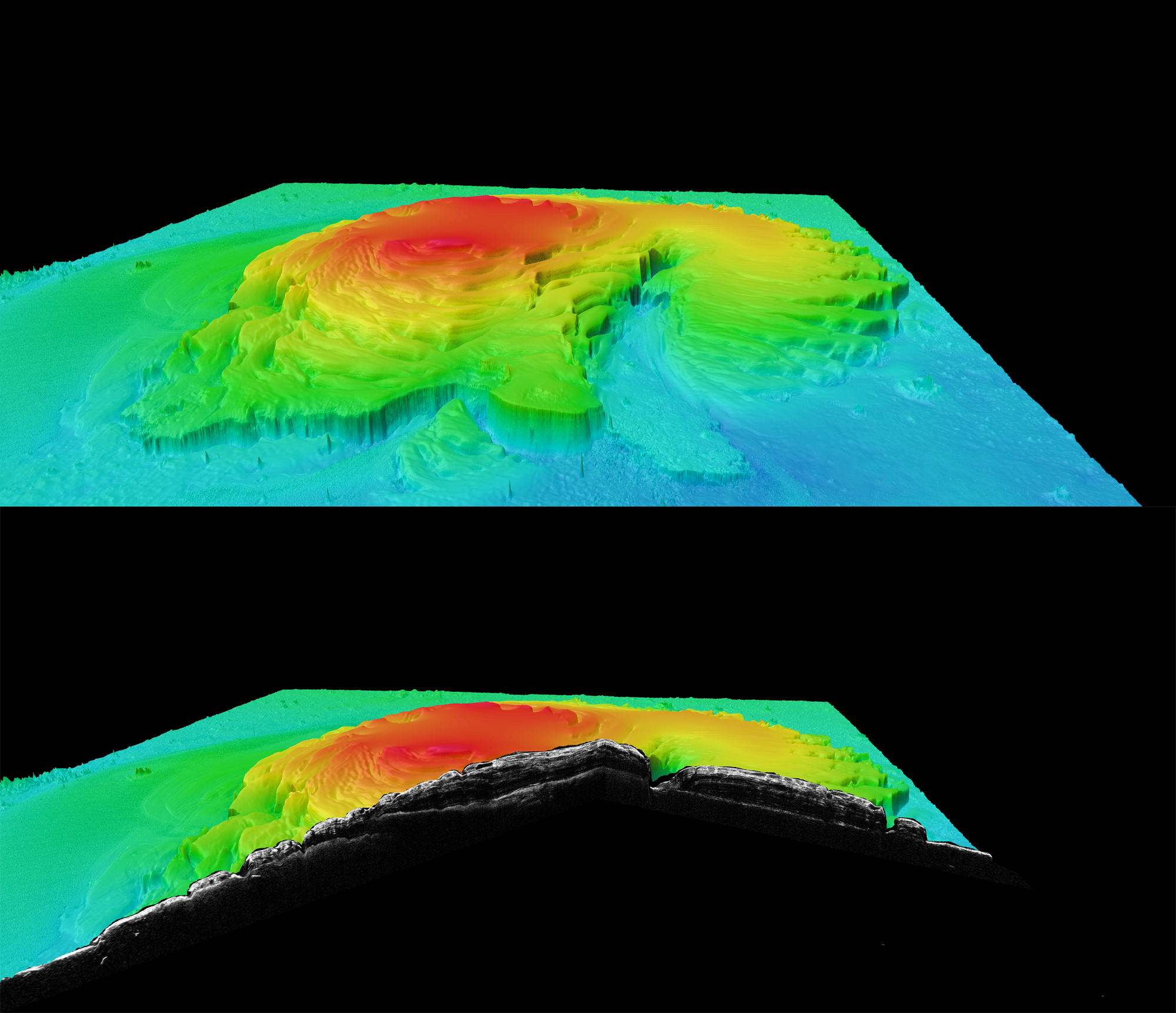
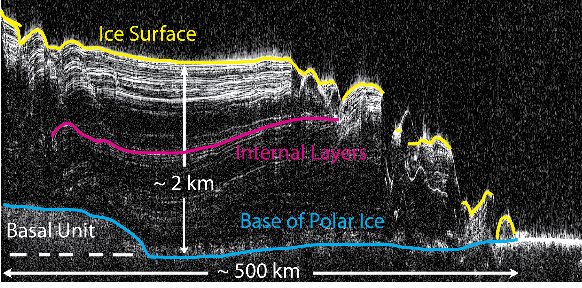
In a pair of papers to be published in the journal Nature on May 27, Jack Holt and Isaac Smith of The University of Texas at Austin’s Institute for Geophysics and their colleagues describe how they used radar data collected by NASA’s Mars Reconnaissance Orbiter to reveal the subsurface geology of the red planet’s northern ice cap.
On Earth, large ice sheets are shaped mainly by ice flow. But on Mars, according to this latest research, other forces have shaped, and continue to shape, the polar ice caps.
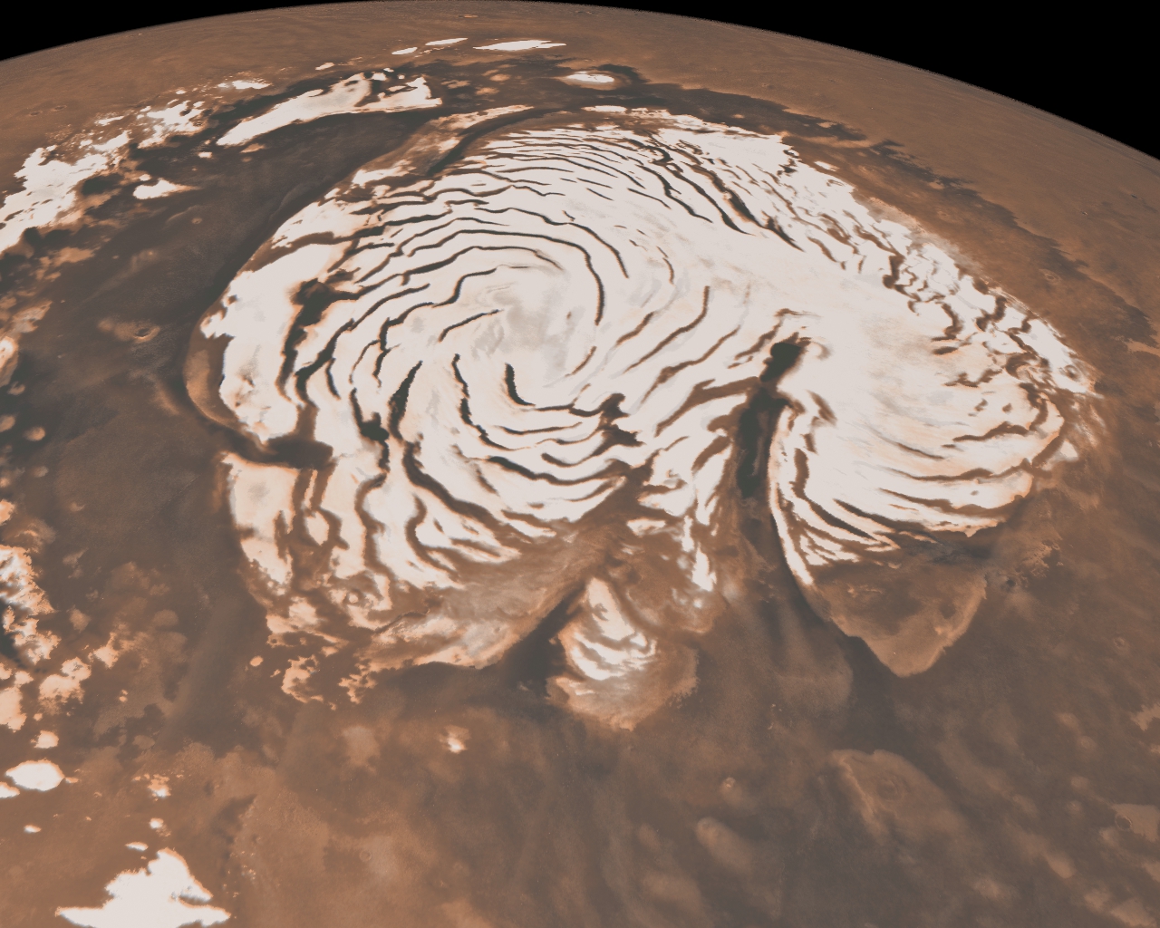
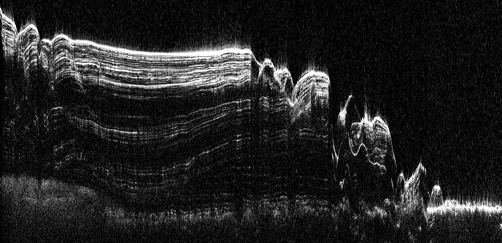
The northern ice cap is a stack of ice and dust layers up to two miles (three kilometers) deep covering an area slightly larger than Texas. Analyzing radar data on a computer, scientists can peel back the layers like an onion to reveal how the ice cap evolved over time.
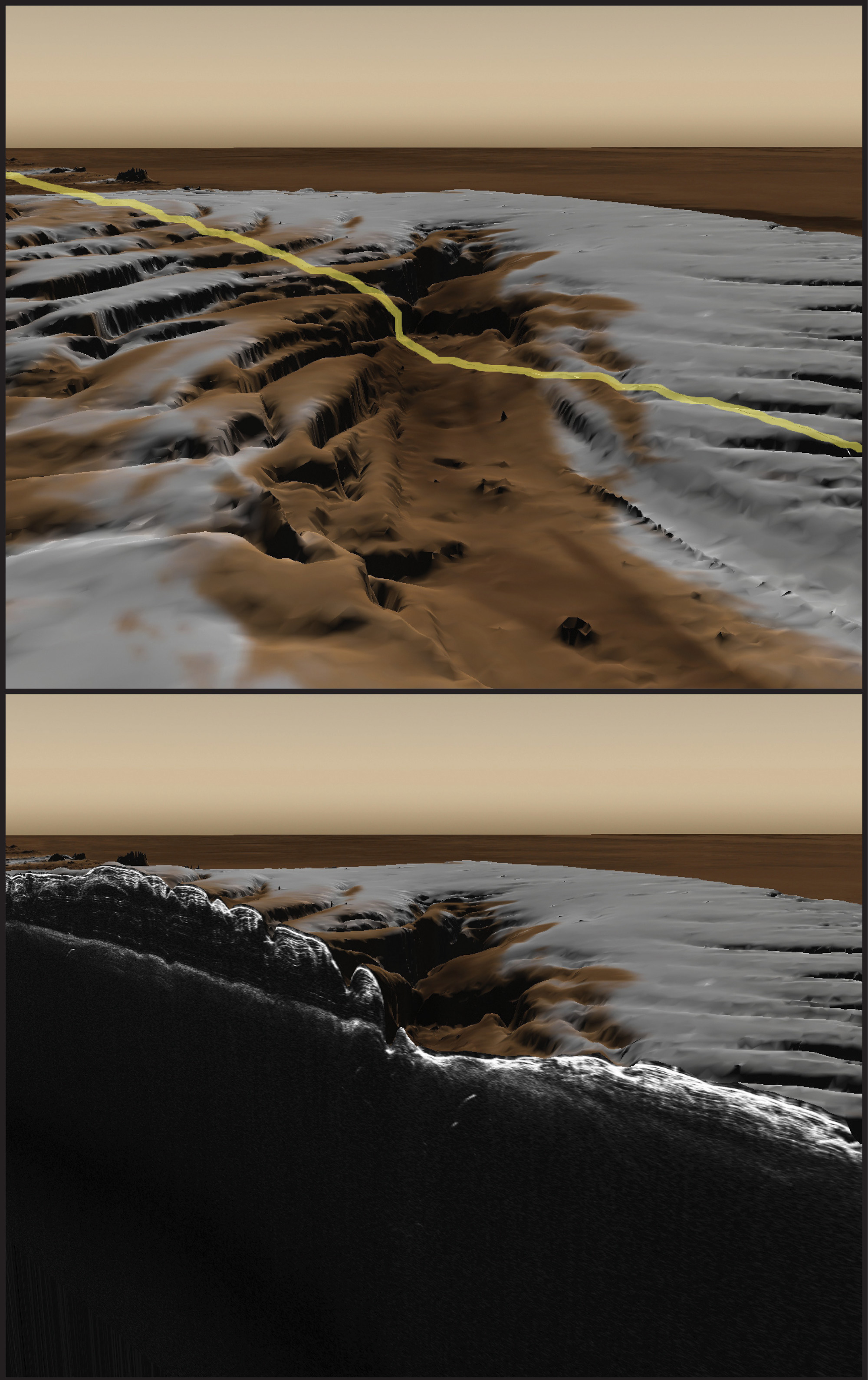
One of the most distinctive features of the northern ice cap is Chasma Boreale, a canyon about as long as the Grand Canyon but deeper and wider. Some scientists have suggested Chasma Boreale was created when volcanic heat melted the bottom of the ice sheet and triggered a catastrophic flood. Others have suggested strong polar winds, called katabatics, carved the canyon out of a dome of ice.
Other enigmatic features are troughs that spiral outward from the center of the ice cap like a gigantic pinwheel. Since they were discovered in 1972, scientists have proposed several hypotheses for how they formed. One suggested that as the planet spins, ice closer to the poles moves slower than ice farther from the poles, causing the semi-fluid ice to crack. Another used an elaborate mathematical model to suggest how increased solar heating in certain areas and lateral heat conduction could cause the troughs to self assemble.
It turns out both the spiral troughs and Chasma Boreale were created and shaped primarily by wind. But rather than being cut into existing ice very recently, the features formed over millions of years as the ice sheet itself grew. By influencing wind patterns, the topography of underlying, older ice controlled where and how the features grew. Topography is the three-dimensional shape of a surface, including peaks, valleys, slopes and plains.
Before this research, conventional wisdom held that the northern ice cap of Mars was made of many relatively flat layers like a layered cake. It was assumed some climate information would be recorded in the layers, limited to what could be gained from layer thickness and dust content. This research, however, reveals many complex features—including layers that change in thickness and orientation, or abruptly disappear in some places—making it a virtual gold mine of climate information.
“Nobody realized that there would be such complex structures in the layers,” says Holt, lead author of the paper focusing on Chasma Boreale. “The layers record a history of ice accumulation, erosion and wind transport. From that, we can recover a history of climate that’s much more detailed than anybody expected.”
The spiral trough results vindicate an early explanation that had fallen out of favor in parts of the Mars scientific community. Alan Howard, a researcher at the University of Virginia, proposed just such a process in 1982 based solely on images of the surface from the Viking mission.
“He only had Viking images with relatively low resolution,” says Isaac Smith, doctoral student and lead author on the spiral trough paper. Holt is second author on the trough paper. “Many people proposed other hypotheses suggesting he was wrong. But when you look at a hypothetical cross section from his paper, it looks almost exactly like what we see in the radar data.”
Why are the troughs spiral shaped? First, katabatic winds are caused by relatively cold, dense air that rolls down from the poles and out over the ice cap. Second, as they blow down, they are deflected by the Coriolis force, which is caused by the planet’s spinning in space. On Earth, this is what causes hurricanes to spin opposite directions in opposite hemispheres. This force twists the winds—and the troughs they create—into spiral shapes.
These breakthroughs were made possible by a new instrument called Shallow Radar (SHARAD). Similar instruments have been used on aircraft in Antarctica and Greenland, but before its use at Mars, some scientists were skeptical it would be able to collect useful data from orbit. Holt is a Co-Investigator on SHARAD.
“These anomalous features have gone unexplained for 40 years because we have not been able to see what lies beneath the surface,” said Roberto Seu, team leader for the SHARAD instrument. “It is gratifying to me that with this new instrument we can finally explain them.”
SHARAD is provided to NASA by the Italian Space Agency. It has been designed and developed and is operated by a joint team formed by Sapienza University of Rome’s INFOCOM Department and Thales Alenia Space Italy.
Co-authors on the paper “The Construction of Chasma Boreale on Mars” include Kathryn Fishbaugh (Smithsonian National Air and Space Museum), Shane Byrne (Lunar and Planetary Laboratory, University of Arizona), Sarah Christian (University of Texas Institute for Geophysics and Bryn Mawr College), Kenneth Tanaka (Astrogeology Science Center, U. S. Geological Survey), Patrick Russell (Planetary Science Institute), Ken Herkenhoff (Astrogeology Science Center, U. S. Geological Survey), Ali Safaeinili (Jet Propulsion Laboratory), Nathaniel Putzig (Southwest Research Institute) and Roger Phillips (Southwest Research Institute).
Funding was provided by NASA and the Gayle White Fellowship at the Institute for Geophysics.
MORE INFO FOR JSG WEBSITE
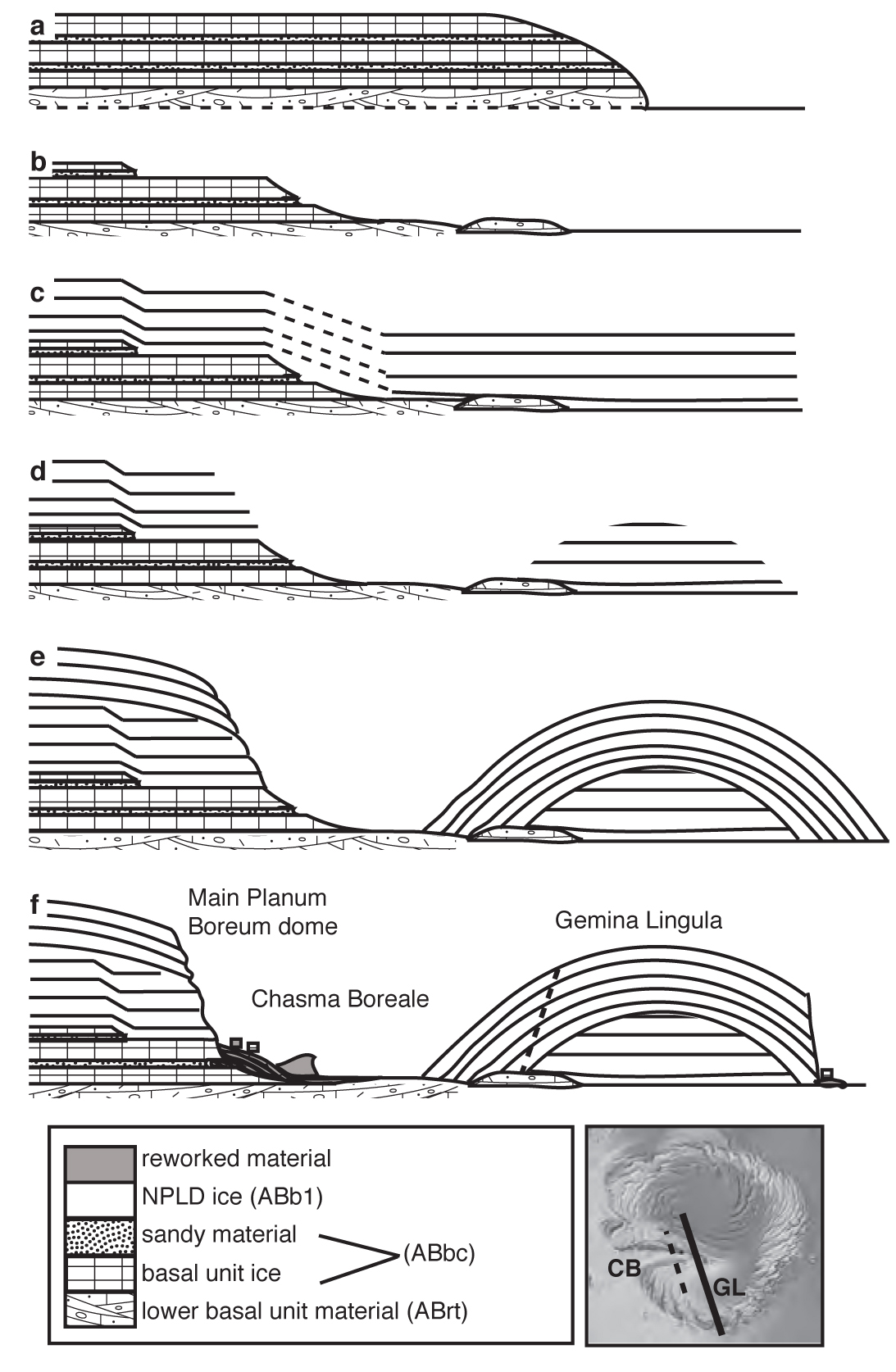
The scientists discovered that a combination of wind and pre-existing topography led to the formation of Chasma Borealle and the spiral troughs. Here’s more detail on that underlying topography.
The radar data reveal that before the formation of the current northern ice cap, technically known as the Northern Polar Layered Deposits (NPLD), there was an older and smaller dome of ice and dust at the north pole. Along the edge of that earlier dome, there were sharp steps down to the surrounding plain. At some point, climate changed in way that allowed for an ice cap covering a much larger area. New layers of ice draped over the existing ice cap and out over the surrounding plain. Along the edge of the original dome, strong polar winds called katabatic winds periodically scoured away young ice leaving behind Chasma Boreale. In other words, the pre-existing topography (with help from wind) created a region where new ice couldn’t build up as quickly, even as the new ice cap was growing all around.
The radar data also reveal that the first spiral troughs began to appear sometime in the last 2 million years, and a second generation of troughs came about some time after. The ice sheet was fairly flat, but there were areas where the surface had a slight slope. Troughs began to form near these slopes because of wind speed variations. Katabatic winds picked up ice crystals from the slope, carried them briefly across the terrain, and then deposited them later on, when the wind speed slowed. Over time, this formed dunes that grew while the troughs deepened and migrated as much as 65 kilometers (40 miles) toward the pole. The troughs have continued to grow and migrate up to the present.
The various hypotheses that had been put forward to explain the chasma and the troughs can be lumped into those that involve laying down the ice sheet first and then carving out the features and those that involve somehow preferentially adding ice in some places and not adding it in others. All of the first set of hypotheses predict that when you look at the radar data in the area of a spiral trough, you should be able to trace a layer straight across from one side to the other even though material is missing. It turns out that they don’t see that in the radar data. Instead, they see a layer come in on one side of a trough and then reappear at a different elevation with a different thickness on the other side. This effectively rules out an entire class of hypotheses and constrains the remaining few.
“We’ve ruled out at least half a dozen hypotheses,” says Smith. “Since we know what didn’t happen, we can now focus a lot of people’s energy on what actually happened.”
In addition to wind and topography, these features may have grown with help from the sun. Features on the surface of the ice that face away from the pole receive more sunlight and heat than features facing toward the pole. This causes more ice to be vaporized and stripped away from some areas and allows the wind to carry the water vapor to other areas where it can precipitate onto the surface as ice crystals.
Scientists looking at radar data gathered on Earth from East Antarctica have identified features called Megadunes that are similar to Martian troughs. They aren’t as long or deep as the ones on Mars, aren’t spiral shaped, and they formed over a much shorter time period. The Antarctic troughs aren’t as big because they didn’t have as long to grow. They aren’t spiral shaped because the wind patterns blowing over East Antarctica are much more complicated than the katabatic winds at the Martian north pole. Still, Smith says they may be useful analogs for what happened on Mars.
Curiously, the first spiral troughs began forming after about three-quarters of the ice cap formed.
“This suggests that there was a big change in climate on Mars around that time,” says Smith.
A second set of spiral troughs formed later, suggesting a second change in climate. The researchers also discovered the troughs migrated towards the poles over time. The rate at which they moved provides still more clues about what climate was like at various times. That’s because the speed of migration is directly related to the speeds of the katabatic winds and the rate of ice deposition. Taken together, these observations could allow scientists to make much more accurate models of past climate on Mars.
“Explaining these anomalous features that people have wondered about for 40 years is very exciting,” says Holt. “To me what’s most exciting is discovering that there is a rich history of climate processes and events that are within the polar cap that we can recover using radar.”
Over the past 10 years, evidence has mounted that Mars has experienced major episodes of global glaciation in which water ice was transferred between the poles and lower latitudes. Part of that history was revealed last year when Holt and his colleagues announced the discovery of giant glaciers of water ice on Mars at mid-latitudes. Their latest research may provide the key to better understanding past episodes of glaciation.
“We’ve found a rich and complex record of climate processes stored in polar deposits that we can recover from the radar,” says Holt. “That’s important because now we can start to link changes in the polar ice to these glacial periods where ice moved from the poles to the middle latitudes.”
For more information about research at the Jackson School, contact J.B. Bird at jbird@jsg.utexas.edu, 512-232-9623.