
X-Ray Vision: Tomography Helps Decipher Great North American Jigsaw Puzzle
February 15, 2008
The American West is something of a seismic puzzle, and researchers are trying to figure out how the pieces got their shapes and what the picture on the box looks like.
“The western U.S. is interesting because it’s divided into distinct provinces each with different topography and tectonic behavior,” says Stephen Grand, Carleton Professor of Geophysics at the Jackson School of Geosciences, “yet one-hundred million years ago, all of these provinces were near sea level.”
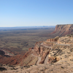
The five provinces—the Great Plains, the Rocky Mountains, the Colorado Plateau, the Rio Grande Rift, and the Basin and Range—now offer great contrast with plenty of seismic activity, volcanoes, and faulting. But such chaos has occurred away from tectonic-plate boundaries, where most seismic activity happens, adding to the questions about this geological jigsaw puzzle.
Using seismic imaging, or tomography, Grand has studied the deep structural differences between the provinces. The process is analogous to taking X-rays of the Earth’s crust and mantle, and has enabled Grand to learn much about mantle structure and behavior. With a focus on the confluence of the West’s tectonic provinces, Grand and other researchers have been able to answer long-standing questions—and raise a few new ones—about relations between subsurface and surface geology, regionally and globally.
“Every time someone goes and does imaging below the western U.S., it seems like we’re finding surprises,” says Gene Humphreys, University of Oregon professor of geophysics. “Until Steve came along, people didn’t think the western U.S. was different from anywhere else.”
A Western Profile
The western puzzle pieces began taking their current shapes and dimensions about 100 million years ago with the shallow subduction of the Farallon Plate beneath the North American Plate. The collision produced volcanoes, which formed the Sierra Nevada of California at the plate boundary. Beneath the North American Plate, the shallow interaction uplifted the Rocky Mountains, beginning around 75 million years ago.
But an abrupt change occurred beginning about 30 million years ago—“a flip-flop of plate tectonics,” says Rick Aster, professor of geophysics at the New Mexico Institute of Mining and Technology, who teamed with Grand and others on the tomography project. The region stopped compressing, as the formation of the San Andreas fault system cut off the Farallon plate’s trailing edge, and began extending. Hot mantle upwelling behind the foundering Farallon plate spurred an enormous outbreak of volcanism across much of what is now the southwestern United States. The extension process formed the Rio Grande Rift beneath Colorado and New Mexico, the broad Basin and Range of southern Arizona and westernmost Texas, and the Great Basin of Utah and Nevada, and it continues today. The effects of the flip-flop became a key focus of the seismic imaging project of Grand, Aster, and other colleagues.
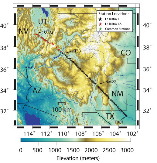
To generate a panoramic tomography of the American West, the group set up a transect of seismometers, known as LA RISTRA, stretching from Texas to Utah through the Four Corners area. A shorter second line later extended the profile to near the Nevada border, giving an unprecedented view of the seismic structure and activity across 1,400 kilometers of the West. This tomographic model is inspiring similar and even larger projects on continents around the globe.
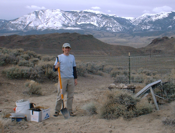
Beginning in July 1999, Grand and the other researchers placed 54 passive broadband seismometers across the Southwest. (The National Science Foundation provided support and its collection of instruments.) The team left the seismometers, spaced 18 kilometers apart, for nearly two years until May 2001. During that period, the instruments measured and recorded all the P-waves and S-waves above a magnitude-5 tremor that traveled through the mantle and lithosphere.
Seismic imaging is conceptually similar to medical X-rays in the way it creates a detailed, cross-sectional picture. Grand and other scientists compare the work to taking a CAT scan of the Earth. Geologists even use mathematical algorithms similar to those used by medical researchers to make images.
“It’s like X-ray vision,” Aster says. “It’s really revolutionizing the way we understand how the lithosphere, mantle, and crust interact.”
The advance in tomography has followed a significant increase in the capabilities of seismometers in the last decade, Grand says. Just as CAT scans have allowed doctors to assess the inner workings of our brains and bodies, seismologists can now consider the deep mantle and its stirrings—which is among Grand’s professional passions— when studying surface geology. The instrumentation of LA RISTRA makes the resulting seismic profile “the best in the region” says Grand, because of its detail and resolution.
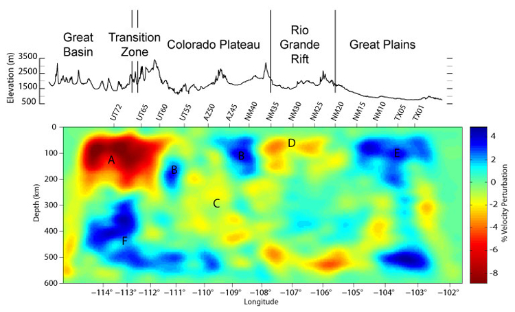
At the eastern end of the profile, the scientists confirmed that the lithosphere has remained thick under the Great Plains and then thins out along the Rio Grande Rift. That was no revelation, since rifts usually stretch the lithosphere, but the group did find one of its major surprises along this section of the line: a “blob” of fast-sinking, cool material that is seen as deep as 600 kilometers beneath the surface. Centered under the town of Artesia, New Mexico, near the edge of the plains and the rift zone, the discrete feature could partly explain the high elevation at the western edge of the Rio Grande Rift and some its volcanic activity.
Grand believes the mass may be the result of edge-driven convection, where a current is created as cold material sinks off the bottom of the edge of cold lithosphere and hot material wells up from the mantle to replace it. The team left the seismometers, spaced 18 kilometers apart, for nearly two years. During that period, the instruments measured and recorded all P-waves and S-waves above a magnitude 5 tremor that traveled through the mantle and lithosphere.
Other seismologists have questioned whether the blob is “an artifact of the imaging,” says Humphreys of the University of Oregon. But the feature—he calls it a “drip,” or, technically, “convective instability”—does help explain the ongoing seismic and volcanic activity, and Humphreys is inclined to agree with Grand’s conclusions.
While the Rio Grande zone has split open, the neighboring Colorado Plateau has remained intact. Research has shown that other high plateaus around the world, specifically Tibet and the Andean Altiplano of South America, have gained elevation due to a thick crust. But the tomography from LA RISTRA shows that the Colorado Plateau’s height is not due to a very thick crust, but a consequence of a heated and less dense mantle and the very slow-moving velocity of the mantle.
“People had speculated on this, but I think our results were definitive,” Grand says of the findings.
“Steve was probably the first guy who actually defined what the seismic velocity structure is beneath the western U.S., and to recognize there was something unusual happening there,” says Humphreys.
More unusual happenings were discovered along the edges of the Colorado Plateau and the Basin and Range provinces, which led Grand and his colleagues to create LA RISTRA 1.5, the follow-up profile extending further west. The group used 18 seismometers to collect data for two years, from June 2004 to May 2006, to add to the original results.
In the original profile, the researchers recognized a sharp contrast between the provinces’ crusts. The extended transect allowed them to gain insight about the structure of the lithosphere and deep mantle beneath the Basin and Range region.
The plateau is “sort of under attack from the west,” says Aster of New Mexico Tech. Convection at the seam of the provinces is warping the edges of the Colorado Plateau. The seismic profile and record of volcanism suggest the mantle beneath the Great Basin, powered by upwelling, is eating away at its neighboring province, and the tomography from the study suggests a close relationship between the subsurface stirrings of the planet’s mantle and the warping and resulting erosion of plateau regions over time.
“One of the key things we are discovering,” Aster says, “[is that] the deep parts of the Earth, down to at least several hundred kilometers, are coupled with the shallow parts of the Earth in fascinating ways.”
“It’s just that we don’t know much about the deep mantle,” adds Grand. “We’re creating new questions, but I also think we answered other questions. What excites me most are the unexpected observations.”
The Tomography of Tomorrow
Grand hasn’t solved all the mysteries of the western seismic puzzle yet, but his work in tomography has made him a pioneer in a pioneering science.
“He’s one of the most widely known, widely respected people in seismology,” Humphreys says of Grand, adding that his legacy is tied to global research as well as the findings derived from his tomography of the American West. Grand has spent years addressing fundamental issues about mantle structure, composition, and convection, which has made him a leader in the field and led him to his ongoing pursuits.
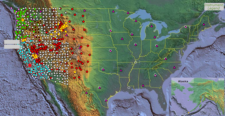
Projects like LA RISTRA have contributed to the creation of EarthScope, the major national initiative to create the first-ever, three-dimensional tomographic profile of the entire country. Scientists are placing a combination of permanent and portable seismographs across the continental U.S. A transportable array of broadband seismometers is being deployed in a uniform, rolling, 70-km grid. Within this low resolution survey, scientists are deploying a flexible array of broadband stations, short period stations, and active source stations for focused, high resolution studies. Deployment began in California. Widespread deployment will reach Texas by 2009.
“[EarthScope] is going to make a data set available that is unprecedented,” Grand says.
Teaming with Jay Pulliam, a research scientist jointly appointed to the Jackson School’s Department of Geological Sciences and Institute for Geophysics, Grand plans to study whether edge-driven convection is responsible for the cool blob at the edge of the Rio Grande Rift. That study could contribute more insight about the causes of tectonic activity separate from plate tectonics. He is also working on a tomographic study of subduction in Mexico and a massive study, three or four times larger in area than LA RISTRA, in China.
Within the next ten or so years, through advances in tomography and instrumentation, Grand predicts he will be able to gain even more detail in his research of the deep mantle. He hopes imaging will allow scientists to get a better understanding of the mantle’s physical properties and how mantle processes further impact surface geology.
“I believe in the next decade or two,” says Grand, “we’ll understand the operating forces in many of these regions.”
by Joshua Zaffos
For more information about the Jackson School contact J.B. Bird at jbird@jsg.utexas.edu, 512-232-9623.